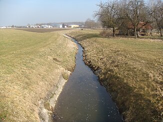
Wangener Bach
| Wangener Bach | ||
|
Wangener Bach towards Iller |
||
| Data | ||
| location | Germany , Baden-Wuerttemberg | |
| River system | Danube | |
| Drain over | Iller → Danube → Black Sea | |
| source | 1 km northwest of Regglisweiler 48 ° 14 ′ 13 ″ N , 10 ° 2 ′ 8 ″ E |
|
| Source height | approx. 540 m above sea level NN | |
| muzzle | 1 km east of Illerrieden at river kilometer 16.2 in the Iller 48 ° 16 ′ 7 ″ N , 10 ° 3 ′ 47 ″ E |
|
| Mouth height | 501 m above sea level NN | |
| Height difference | approx. 39 m | |
| Bottom slope | approx. 6.5 ‰ | |
| length | 6 km | |
The Wangener Bach rises northwest of Regglisweiler in the Gewann Holzkrähe, a suburb of the city of Dietenheim in the Alb-Danube district in Upper Swabia .
course
It drains some of the wooden sticks towards the east into the Iller . It flows south of the Kreuthöfe into the area of the Illerriedener district of Wangen . From here it flows through the Kreutfeld to Wangen, where it flows canalized through the village and to the north of it comes to the surface again. Now it flows through the Gewann im valley into the Illerauwald, where it flows through the Russenweiher and flows into the Iller at river kilometer 16.2.
Web links
Commons : Wangener Bach - Collection of images, videos and audio files
Coordinates: 48 ° 15 '46.9 " N , 10 ° 3' 38.9" E

