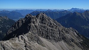
Wasserfallkarspitze
| Wasserfallkarspitze | ||
|---|---|---|
|
Wasserfallkarspitze from Urbeleskarspitze (2632 m) |
||
| height | 2557 m above sea level A. | |
| location | Tyrol , Austria | |
| Mountains | Hornbach chain , Allgäu Alps | |
| Dominance | 1.4 km → Urbeleskarspitze | |
| Notch height | 211 m ↓ notch to the Zwölferspitze | |
| Coordinates | 47 ° 20 '38 " N , 10 ° 29' 6" E | |
|
|
||
| Type | Rocky peaks with scree and crags | |
| rock | Main dolomite | |
The Wasserfallkarspitze (also Deiserspitze ) is 2557 m above sea level. A. high mountain in the Allgäu Alps in Tyrol .
Location and surroundings
The Wasserfallkarspitze is located in the Hornbach chain west of Elmen in the Lech Valley . Its neighboring peaks are the 2512 m high Elferspitze in the west and the 2496 m high Schwellenspitze in the northeast . In the north, the Faulholzerkar lies above Hinterhornbach in the Hornbachtal . In the south lies the Wasserfallkar, in the east the Großkar.
Ascent
The Wasserfallkarspitze can be climbed from Klimm near Elmen in around 4½ hours. You first follow the marked path to the Klimmspitze to the edge of the Großkar. From here you cross the pathless Großkar to a trough in the southeast ridge, the one in Alpine difficulty UIAA I achieved. The summit is easy to reach from here.
literature
- Dieter Seibert: Allgäuer Alpen Alpin, alpine club guide . Bergverlag Rudolf Rother , Munich 2004, ISBN 3-7633-1126-2
- Kompass Digital Map Tirol, Version 2.4.1.0, Kompass Karten GmbH Innsbruck
Web links
Individual evidence
- ↑ Alpine Club Card No. 2/2 Allgäu Alps East
Klimmspitze , Wasserfallkar- and Urbeleskarspitze


