
Wasserkopf (Rieserferner Group)
| Water head | ||
|---|---|---|
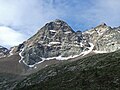
 Wasserkopf from the southeast, from the connecting ridge to Morgenkofel |
||
| height | 3135 m slm | |
| location | South Tyrol , Italy | |
| Mountains | Rieserferner Group | |
| Coordinates | 46 ° 53 '36 " N , 12 ° 3' 13" E | |
|
||
| First ascent | July 1884 by C. Wildberg led by Johann Niederwieser | |
| Normal way | From Morgenkofel over the southeast ridge ( II ) | |

The Wasserkopf ( 3135 m , according to other information 3141 m slm , Italian Cima dell'Acqua ) is a summit in the western part of the Rieserferner group in South Tyrol . It is under protection in the Rieserferner-Ahrn Nature Park .
The showpiece of the mountain is the north side, which breaks off steeply over 650 meters into the Gelttal . It is also known as the "small Eiger North Face" because it looks similar to this most famous north face in the Alps. This wall was first climbed in August 1977, and at the beginning of the 21st century new routes were also used for the first time.
Location and surroundings
The Wasserkopf is located in the main ridge of the Rieserferner Group, which runs from this summit in a westerly direction over the Großem Fensterlekofel ( 3171 m ) and Rauchkofel ( 3043 m ) to the Großer Windschar ( 3041 m ). A little east of the Wasserkopf, the main ridge bends almost at right angles to the south, in the further course there is the Morgenkofel ( 3073 m ), which is a little more than 500 meters away from the Wasserkopf, another 600 meters south-east is the Black Wall ( 3105 m ) . The Gelttalferner used to extend from the north side of the Black Wall to the eastern flank of the Wasserkopf.
To the north and east of the Wasserkopf is the Gelttal , a side valley of the Reintal , which branches off from it in a south-easterly direction. Southwest of the summit are the alpine pastures at the end of the Mühlbachtal , which branches off from the Tauferer Tal near Gais to the northeast.
The tower-like summit breaks off almost vertically for about 150 meters to the southwest. Even more impressive is the north side, which slopes steeply for almost 700 meters into the Gelttal .
Alpinism
In July 1884, C. Wildberg and his guide Johann Niederwieser , called Stabeler, were the first to reach the summit of the Wasserkopf. They rose from the Mühlbach valley. The exact route has not been recorded. About two years later, on July 31, 1886, C. Noster and A. Benzien from Berlin and Hans Hörhager from Dornauberg made the first ascent of the southeast ridge, which is now the easiest route. These had already climbed the Black Wall and had descended to the Gelttalferner . From there they got to the connecting ridge of Morgenkofel and Wasserkopf and over this to the summit, whereby the fracture of the ridge and a three meter high vertical wall step caused them problems. In the same year, on September 10, 1886, Ludwig Meyer from Vienna reached the summit with guide Stefan Kirchler, also coming from the Mühlbachtal, through a couloir that climbed to the southwest ridge and reached the ridge in the immediate vicinity of the summit. The descent took place over the west ridge leading to the Fensterlekofel and from the deepest notch of this ridge section down into the Mühlbachtal.
Werner Beikircher and Hans Kammerlander first climbed the north face of the Wasserkopf on August 7, 1977 . Ulrich Viertler, Raffaele Sebastiani and Alexander Mayer first climbed a new route, more direct in the lower part of the wall and known as "Hydrocephalus". Another route, a little further to the right in the upper part, was opened by Veit Bertagnolli and Roland Marth on April 5, 2014 and referred to as "Aquarius". In the same year, on November 25, 2014, Simon Gietl and Vittorio Messini opened another, very direct line in the north face of the Wasserkopf with the “Hakuna Matata” route.
The ascent to the Wasserkopf, which is usually done today, first leads from the Mühlbachtal on a marked trail to the Morgenkofel . The rest of the route over the connecting ridge to the Wasserkopf usually follows the ridge directly; cairns and an old climbing system make it easier to find the way over long distances. The key point is the crossing of a ledge in the eastern flank, where a rope can be secured. When you reach the summit structure, you do not climb it directly, but bypass it to the north. The last few meters are easy climbing from the north to the summit. The connecting ridge has climbing difficulties of the I and in places II. Difficulty level.
Wasserkopf from the north from the Gelttal

Key point on the southeast ridge in the descent

The summit tower of the Wasserkopf from the southeast


Literature and map
- Maurizio Marchel: Lonely peaks in South Tyrol - Dolomites. Volume 2, Tappeiner, Lana 2013, ISBN 978-88-7073-714-1 , p. 50f.
- Topographic hiking map: Ahrntal / Rieserferner Group. Sheet 035, 1: 25,000, Casa Editrice Tabacco, 2002, ISBN 88-8315-035-X .
Individual evidence
- ↑ a b c d Ahrntal / Rieserferner Group. Topographic hiking map. Sheet 035, 1: 25.000, Casa Editrice Tabacco, ISBN 88-8315-035-X .
- ↑ a b c C. Diemer: The Rieserferner Group. In: The development of the Eastern Alps. III. Volume: The Central Alps east of the Brenner and the southern Limestone Alps. Publishing house of the German and Austrian Alpine Association, Berlin 1894, pp. 124–126. (on-line)
- ↑ a b Alpine Association South Tyrol: Hydrocephalus, Wasserkopf North Face, Riesenferner Group. 21st May 2013.
- ↑ bergstieg.com: Hakuna Matata. Simon Gietl and Vittorio Messini manage a first ascent in the "small Eiger north face" of the Wasserkopf. . 2nd December 2014.
- ↑ Maurizio Marchel: Lonely peaks in South Tyrol - Dolomites. Volume 2, Tappeiner, Lana 2013, ISBN 978-88-7073-714-1 , p. 50f.
Web links
- Wasserkopf in alpinwiki.at