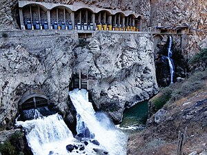
Cañón del Pato hydroelectric power station
| Cañón del Pato hydroelectric power station | |||
|---|---|---|---|
| Discharge of the turbine water into the river | |||
| location | |||
|
|
|||
| Coordinates | 8 ° 48 '26 " S , 77 ° 50' 57" W | ||
| country |
|
||
| place | Ancash region | ||
| Waters | Río Santa | ||
| Data | |||
| power | 243 MW | ||
| operator | Orazul Energy Perú SA | ||
| Construction time: | 1942-1958 | ||
| Start of operations | 1958 | ||
| turbine | 6 Pelton turbines | ||
The Cañón del Pato hydropower plant (Spanish: Central Hidroeléctrica Cañón del Pato ) is located on the Río Santa in northwest Peru , 370 km north-northwest of the state capital Lima . The power plant is located in the Huallanca district in the Huaylas province of the Ancash administrative region . In the immediate vicinity is the Quitaracsa hydropower plant on the Río Quitaracsa, a right tributary of the Río Santa.
Hydroelectric power plant
The cavern power plant , located at an altitude of 1423 m , is located in the Peruvian Western Cordillera at the lower end of the eponymous canyon Cañón del Pato (Spanish for "duck canyon"), 8 km north-northeast of the provincial capital Huaylas .
The hydropower plant went into operation in 1958. Initially, the power plant was equipped with two 25 MW turbines. In 1967 and 1981 two more turbines were added, so that the total output increased from 50 MW to 100 MW and finally to 150 MW. The hydropower plant was modernized at the end of the 1990s. The old turbines were replaced by six new turbines. In 2016, the corporation I Squared Capital took over the power plant from Duke Energy . Since then, the plant has been operated by Orazul Energy Perú SA.
The hydropower plant currently has six Pelton turbines with an output of 40.6 MW each. The power plant uses a gross drop height of 415 meters (net head: 383 m). The expansion water volume is 72 m³ / s. The annual energy production in 2015 was 1580 GWh. The subterranean engine house has the following dimensions: 110 m long, 9.5 m wide and 14.5 m high. It can be reached via a 375 m long access tunnel. The substation ( ⊙ ) is located on the left bank of the river at the exit of the gorge.
dam
The San Diego Dam ( ⊙ ) is located about 8.7 kilometers upstream on the Río Santa. It was completed in 2001 and consists of a gravity dam. This dams the river, especially in the dry season, so that a higher head can be achieved. Much of the river water is drained off at the dam. The water is led through a nearly 9 km long tunnel along the right slope of the valley to a compensation chamber, from where three 433.6 m long pressure tunnels lead to the power station. The water is fed back into the river below the power station.
More water storage
The catchment area of the dam covers 4897 km². This includes the western flank of the Cordillera Blanca . In order to ensure sufficient water for the operation of the power plant even in times of low precipitation, several lakes upstream were provided with dams. These are: Laguna Parón (1992 ⊙ ), Laguna Cullicocha (1992 ⊙ ), Laguna Aguascocha (2003 ⊙ ) and Laguna Rajucolta (2005 ⊙ ). These have a total usable storage space of 70 million m³.
![]() Map with all coordinates: OSM | WikiMap
Map with all coordinates: OSM | WikiMap
Individual evidence
- ↑ a b c Michael Palomino: Historia de Chimbote 08: central hidroeléctrica del cañón del Pato . www.am-sur.com. 2011. Retrieved September 28, 2019.
- ↑ a b Hidroeléctrica del Cañón del Pato . infraestructuraperuana.blogspot.com. November 11, 2015. Retrieved September 28, 2019.
- ↑ a b Orazul Energy Egenor S. en C. or A. (Egenor) (PDF, 520 KB) Apoyo & Asociados. Retrieved September 29, 2019.
- ↑ a b c Hidroléctrica: Cañón del Pato . equilibriomimundo.blogspot.com. October 18, 2011. Retrieved September 28, 2019.

