Wedi (Armenia)
|
Wedi (Armenia) Վեդի |
||
|
||
| State : |
|
|
| Province : | Ararat | |
| Coordinates : | 39 ° 55 ' N , 44 ° 44' E | |
| Height : | 900 m | |
| Area : | 5.6 km² | |
| Residents : | 11,384 (2011) | |
| Population density : | 2,033 inhabitants per km² | |
| Time zone : | UTC + 4 | |
| Telephone code : | (+374) 234 | |
| Postal code : | 601 | |
| Community type: | city | |
| Mayor : | Varuschan Barseghjan ( HHK ) | |
| Website : | ||
|
|
||
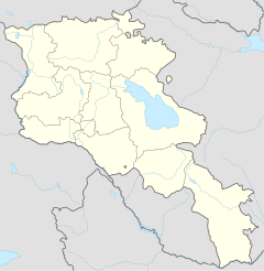
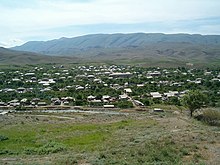
Wedi ( Armenian Վեդի ; English and French transcription Vedi ) is a city in the Armenian province of Ararat . It is located on the river of the same name , about 35 kilometers southeast of the capital Yerevan . The city has about 11,000 inhabitants.
etymology
The name Wedi is derived from the Arabic word wadi ( Arabic وادي), which means the valley . This word could have gotten into Armenian via the Persian language . The city was partly known as Werin Wedi ( Upper Wedi in Armenian) or Böjük Wedi ( Large Wedi in Turkish ). In 1946 the city was officially renamed Wedi .
history
The area of Wedi has been populated since the time of the Urartian Empire . However, the name Wedi was only mentioned in a book by the Armenian historian Stepanos Orbeljans in the 13th century.
At the beginning of the 19th century, Wedi consisted of about 250 families, 95% of which were Caucasian Tatars and 5% were Armenians.
After the Russo-Persian War (1826-1828) and the Peace of Turkmanchai between Persia and the Russian Empire , Wedi became part of the Russian Empire in 1928. During the 1830s around 500 Armenians were allowed to move from the Persian city of Maku to Böjük Wedi. In 1849 the settlement became part of the Yerevan Governorate of the Russian Empire.
In the second half of the 20th century, many families fled the genocide of the Armenians from the western Armenian cities of Van , Çatak and Muş to Wedi.
In 1918 Böjük Wedi became an independent administrative district ( gavar ) within an independent Armenia .
In 1930 Böjük Wedi became part of the newly created Wedi Rajon . In 1946 the place was officially renamed Wedi . During the 1940s and 1950s, Armenians became the majority of the population in Vedi through a new wave of resettlements from families from Sisian , Yeghegnadsor, and Martuni . In 1963 Wedi was given the status of urban-type settlement . In 1968 the Wedi Rajon was renamed Ararat Rajon .
After the independence of Armenia in 1995, Wedi was granted city status.
geography
Wedi is located 35 km southeast of the capital Yerevan, on the right bank of the river of the same name, in the western part of the fertile Ararat plain. The city lies at an altitude of 900 m. In the south of the city lies the Goravan semi-desert, in the north the mountains of Urts.
The climate of Wedi is characterized by extremely cold and snowy winters and relatively warm summers. In winter, temperatures can drop to -32 ° C. Summer, which lasts from May to October, has an average temperature of 25 ° C. The average rainfall is around 225 mm per year.
Demographics
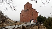
Currently, the population of Wedi consists almost exclusively of Armenians who belong to the Armenian Apostolic Church . The Church of the Holy Mother of God was opened in 2000 and belongs to the Ararat Diocese.
Population development of Wedi since 1831:
| year | 1831 | 1897 | 1937 | 1959 | 1970 | 1989 | 2001 | 2011 | 2016 |
|---|---|---|---|---|---|---|---|---|---|
| population | 1244 | 2798 | 2830 | 3581 | 6165 | 10,757 | 12,963 | 11,384 | 10,600 |
Culture
Wedi's first cultural center was built in the 1930s. This was replaced by a new building in 2013, which houses the city theater and other cultural institutions. The house has a theater group (founded in 1950), a folk music ensemble (founded in 1977), a dance group, a brass band and a children's orchestra. Every summer, the Kulturhaus organizes Wedi's Musical Tuesday in the amphitheater in the city park.
Wedi has also had a public library with around 58,000 books since 1935, as well as a music and art school.
traffic
Wedi is 7 km east of the M-2 motorway, which is connected to the H-10 road. The H-10 continues south-west into the province of Vajoz Dzor .
The capital Yerevan can be reached with regular marshrutkas .
economy
Agriculture plays an important role in Wedi and the surrounding areas. The main products are grapes, apricots and dairy products. Many residents work in this area. The largest company in the city is VediAlco , which was founded in 1956 and is one of the well-known wine and brandy producers in Armenia.
education
Wedi has four kindergartens, two primary schools and one secondary school.
Sports
As in other regions of Armenia, football is the most popular sport in Wedi . In the area of the city park there is a soccer stadium, a swimming pool and a sports hall.
sons and daughters of the town
- Narek Bawejan, Armenian singer and actor
See also
Web links
- Official website of the city (Armenian, English)
Individual evidence
- ↑ http://www.vedicity.am/Pages/DocFlow/Default.aspx?a=v&g=854d4ed2-06cb-455e-86ce-834203a70727 (accessed January 4, 2020)
- ^ Vedi, Ararat Province
- ^ About the community of Vedi
- ↑ About the town of Vedi (Armenian)
- ↑ Wine production in Vedi ( Memento of the original dated February 11, 2014 in the Internet Archive ) Info: The archive link was inserted automatically and has not yet been checked. Please check the original and archive link according to the instructions and then remove this notice.


