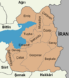
Çatak (Van)
| Çatak | ||||
|
||||
| Basic data | ||||
|---|---|---|---|---|
| Province (il) : | Van | |||
| Coordinates : | 38 ° 1 ' N , 43 ° 4' E | |||
| Height : | 1512 m | |||
| Telephone code : | (+90) 432 | |||
| Postal code : | 65 870 | |||
| License plate : | 65 | |||
| Structure and administration (status: 2018) | ||||
| Structure : | 33 Mahalle | |||
| Mayor : | Hamza Turkmen | |||
| Website: | ||||
| Çatak County | ||||
| Residents : | 20,696 (2017) | |||
| Surface: | 1,952 km² | |||
| Population density : | 11 inhabitants per km² | |||
| Kaymakam : | Hamza Turkmen | |||
| Website (Kaymakam): | ||||
Çatak ( Armenian Շատախ Šatax ) is a former district in the eastern Anatolian city of Van with the rank of a municipality. Çatak is located in the southwest of the province and borders the provinces of Siirt and Şırnak . The municipality ( Belediye ) Çatak consists of 33 districts ( Mahalle ) and is located between the mountains on the river of the same name, which flows into the Botan Çayı .
Individual evidence
- ↑ Nufusu.com , accessed November 11, 2018


