Muradiye
| Muradiye | ||||
|
||||
| Basic data | ||||
|---|---|---|---|---|
| Province (il) : | Van | |||
| Coordinates : | 39 ° 0 ′ N , 43 ° 46 ′ E | |||
| Height : | 1700 m | |||
| Telephone code : | (+90) 432 | |||
| Postal code : | 65 500 | |||
| License plate : | 65 | |||
| Structure and administration (status: 2018) | ||||
| Structure : | 48 mahall | |||
| Mayor : | Harun Yücel | |||
| Website: | ||||
| Muradiye County | ||||
| Residents : | 50,715 (2017) | |||
| Surface: | 912 km² | |||
| Population density : | 56 inhabitants per km² | |||
| Kaymakam : | Harun Yücel | |||
| Website (Kaymakam): | ||||
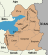
Muradiye ( Armenian Բերկրի Pergri , Kurdish Bêgirî , Ottoman بارکری Bergiri ) is a former district in the Eastern Anatolian city of Van with the rank of a municipality ( Belediye ). Muradiye is in the north of the province and borders the Ağrı Province . The community consists of 48 districts ( Mahalle ), which were villages ( Köy ) before the administrative reform .
The place was first mentioned in 1035 when the Byzantine Emperor Michael IV conquered the place, which had been ruled by Armenian Muslims until then .
In an earthquake on November 24, 1976 with a magnitude of 7.6, up to 3790 people were killed in Eastern Anatolia. The city of Muradiye was largely destroyed.

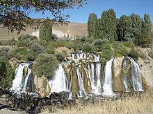
Muradiye waterfall
Worth seeing
Nearby is the Muradiye waterfall , a local destination.
Individual evidence
- ↑ Nufusu.com , accessed November 11, 2018


