Gürpınar (Van)
| Gurpinar | ||||
|
||||
| Basic data | ||||
|---|---|---|---|---|
| Province (il) : | Van | |||
| Coordinates : | 38 ° 20 ' N , 43 ° 25' E | |||
| Height : | 1730 m | |||
| Telephone code : | (+90) 432 | |||
| Postal code : | 65 900 | |||
| License plate : | 65 | |||
| Structure and administration (status: 2018) | ||||
| Structure : | 79 Mahalle | |||
| Mayor : | Osman Doğramacı | |||
| Website: | ||||
| Gürpınar County | ||||
| Residents : | 35,155 (2017) | |||
| Surface: | 4,028 km² | |||
| Population density : | 9 inhabitants per km² | |||
| Kaymakam : | Osman Doğramacı | |||
| Website (Kaymakam): | ||||
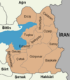
Gürpınar ( Armenian Have-tzor or Հայոց ձոր Hayots-tzor , Kurdish Payîzawa ) is a former district in the eastern Anatolian city of Van with the rank of a municipality ( Belediye ). Gürpınar is located in the south of the province and borders the provinces of Hakkâri and Şırnak . With a fifth of the area, Gürpınar is the largest municipality and has the lowest population density of the big city municipality. It consists of 79 districts ( Mahalle ) that were still villages ( Köy ) before the administrative reform .
Gürpınar used to be called Kiğzi. This name comes from the Armenian word for island. The administrative unit was called Avasor in Turkish. Despite its Kurdish appearance (“Red Water”), this name is of Armenian origin (Hayots-tzor) and means “The Valley of Hayk”. This goes back to the Hayk Castle, which is located in the Mahalle Çavuştepe.
In the municipality are the Armenian monasteries Surp Marinos and Hogots , which were destroyed after the genocide of the Armenians .
Personalities
- Hüseyin Çelik , university professor, politician and former education minister
See also
Individual evidence
- ↑ Nufusu.com , accessed November 11, 2018
- ^ Anatolic index


