İpekyolu
| İpekyolu | ||||
|
||||
| Basic data | ||||
|---|---|---|---|---|
| Province (il) : | Van | |||
| Coordinates : | 38 ° 28 ' N , 43 ° 21' E | |||
| Height : | 1665 m | |||
| Residents : | 279,660 | |||
| Telephone code : | (+90) 432 | |||
| Postal code : | 65xxx | |||
| License plate : | 65 | |||
| Structure and administration (as of 2016) | ||||
| Structure : | 50 malls | |||
| Mayor : | Cemİl Öztürk | |||
| Website: | ||||
| İpekyolu County | ||||
| Residents : | 300,796 (2017) | |||
| Surface: | 956 km² | |||
| Population density : | 315 inhabitants per km² | |||
| Kaymakam : | Cemil Öztürk | |||
| Website (Kaymakam): | ||||
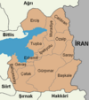
İpekyolu is a former district in the Eastern Anatolian city of Van with the rank of a municipality ( Belediye ). İpekyolu was founded in 2012 by dividing the urban area of Van and is the most populous district of the metropolitan commune. İpekyolu covers the southern part of the city and consists of 50 districts ( Mahalle ).
The name İpekyolu means Silk Road , indicating that Van was an important stop on the Silk Road.
In September 2016, the incumbent mayors Aygül Bidav and Veysel Keser were replaced by a statutory order for the support of a terrorist organization by a state official.
Individual evidence
- ↑ Nufusu.com , accessed November 11, 2018


