Saray (Van)
| Saray | ||||
|
||||
| Basic data | ||||
|---|---|---|---|---|
| Province (il) : | Van | |||
| Coordinates : | 38 ° 39 ' N , 44 ° 10' E | |||
| Height : | 2100 m | |||
| Telephone code : | (+90) 432 | |||
| Postal code : | 65 830 | |||
| License plate : | 65 | |||
| Structure and administration (status: 2018) | ||||
| Structure : | 27 Mahalle | |||
| Mayor : | Mehmet Halis Aydin | |||
| Website: | ||||
| Saray County | ||||
| Residents : | 20,972 (2017) | |||
| Surface: | 872 km² | |||
| Population density : | 24 inhabitants per km² | |||
| Kaymakam : | Mehmet Halis Aydin | |||
| Website (Kaymakam): | ||||
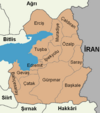
Saray ( Turkish for palace ), ( Kurdish : Mehmûdî ; formerly Mahmudiye ) is a former district in the eastern Anatolian city of Van with the rank of a municipality ( Belediye ). Saray is in the east of the province and borders Iran. The community consists of 27 districts ( Mahalle ), which were villages ( Köy ) before the administrative reform .
In 1869 Saray was elevated to a Kaza and after the founding of the republic in 1923 it was renamed Kâzımpaşa in honor of General Kâzım Özalp . With the enactment of the Family Name Act in 1934, the name of the place was changed to Özalp according to the surname Kâzım Özalps . In 1946 the administration of the district was moved away from the border to the village of Kargalı, which was now called Özalp. The old Özalp became an independent district in 1990 as Saray.
Individual evidence
- ↑ Nufusu.com , accessed November 11, 2018
- ^ Anatolic index


