Baskale
| Baskale | ||||
|
||||
 Bartholomew's Monastery in Başkale district |
||||
| Basic data | ||||
|---|---|---|---|---|
| Province (il) : | Van | |||
| Coordinates : | 38 ° 3 ' N , 44 ° 1' E | |||
| Height : | 2400 m | |||
| Telephone code : | (+90) 432 | |||
| Postal code : | 65 600 | |||
| License plate : | 65 | |||
| Structure and administration (status: 2018) | ||||
| Mayor : | Asim Solak | |||
| Website: | ||||
| Başkale County | ||||
| Residents : | 51,973 (2017) | |||
| Surface: | 2,727 km² | |||
| Population density : | 19 inhabitants per km² | |||
| Kaymakam : | Asim Solak | |||
| Website (Kaymakam): | ||||
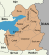
Başkale ( Turkish for main castle ; Armenian Ադամակերտ Adamakert , Kurdish Elbak ) is a former district in the eastern Anatolian city of Van with the rank of a municipality ( Belediye ). Başkale is located in the southeast of the province, bordering Hakkâri Province to the south and Iran to the east. The community consists of 66 districts ( Mahalle ), which were villages ( Köy ) before the administrative reform . It is located at the foot of the İspiriz mountain (3668 m).
The Armenian Holy Cross Monastery of Soradir and the Saint Bartholomew Monastery , which was converted into a military training area after the genocide of the Armenians in 1915, are located in the district.
Personalities
- Ferzende Kaya , journalist and writer
Individual evidence
- ↑ Nufusu.com , accessed November 11, 2018
- ^ The Condition of the Armenian Historical Monuments in Turkey .


