Weiberg
|
Weiberg
City of Büren
Coordinates: 51 ° 30 ′ 45 " N , 8 ° 35 ′ 26" E
|
|
|---|---|
| Height : | 350 m |
| Area : | 5.3 km² |
| Residents : | 655 (Dec. 31, 2019) |
| Population density : | 124 inhabitants / km² |
| Incorporation : | 1st January 1975 |
| Postal code : | 33142 |
| Area code : | 02958 |
|
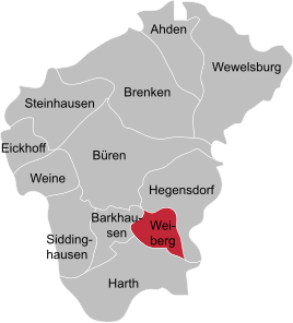
Location of Weiberg in Büren
|
|
|
Weiberg
|
|
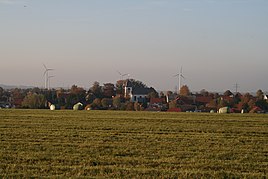
Weiberg is a village in the city of Büren in the Paderborn district , North Rhine-Westphalia . Weiberg has 655 inhabitants (as of December 31, 2019) and is located between the villages of Harth , Barkhausen , Hegensdorf and Keddinghausen .
history
Weiberg was founded around 1500 after the destruction of Hepern . In 1712 a chapel was built in the village by the Bürener Jesuits . It was canceled three years later because it was badly damaged in a fire that same year. At the same place the Jesuits built a statue dedicated to Saint Agatha with the images of Saint Agatha and Saint Joseph.
In 1747 the foundation stone was laid for the Weiberg parish church (St. Birgitta) , which was completed on September 26, 1751. The first pastor of Weiberg was Franz Godfried Caesmann, he took over the parish on November 1, 1752. At that time, Weiberg was subject to rent and service to the Büren house and later to the Jesuits. The community owned extensive " wood just " which were replaced in 1877. From this time on Weiberg was not granted any deputation wood.
During the Seven Years' War , many armies of Hesse, Hanoverians, English, Scots and French moved through the town or took up quarters. In June 1761 a contagious disease broke out, which killed one sixth of the population of Weiberg. At that time, Weiberg and its neighboring towns of Harth and Barkhausen belonged to the Gogericht of the Büren lordship .
On January 1, 1975, the previously independent place was incorporated into the city of Büren.
societies
In Weiberg there is a volunteer fire brigade , a homeland club, a music club, a tennis club, a shooting club and the soccer club FC Weiberg.
traffic
The district roads K 34 and K 35 lead through the village.
Web links
- Web presence of the village Weiberg
- Weiberg in the Westphalia Culture Atlas
Individual evidence
- ↑ Population development 2019 . In: Stadt Büren (Hrsg.): City mirror of the city of Büren . Issue No. 178 , March 7, 2020, p. 4 .
- ^ Geographical Commission for Westphalia (ed.): Geographisch-Landeskundlicher Atlas von Westfalen, Topic X Administration and Management, double sheet state and municipal administrative structure , Münster 1990.
- ↑ History Weibergs. Retrieved April 11, 2014 .
- ^ Federal Statistical Office (ed.): Historical municipality directory for the Federal Republic of Germany. Name, border and key number changes in municipalities, counties and administrative districts from May 27, 1970 to December 31, 1982 . W. Kohlhammer, Stuttgart / Mainz 1983, ISBN 3-17-003263-1 , p. 320 .


