Ahden
|
Ahden
City of Büren
Coordinates: 51 ° 36 ′ 5 ″ N , 8 ° 37 ′ 25 ″ E
|
|
|---|---|
| Height : | 181 m |
| Area : | 9.78 km² |
| Residents : | 998 (Dec. 31, 2019) |
| Population density : | 102 inhabitants / km² |
| Incorporation : | 1st January 1975 |
| Postal code : | 33142 |
| Area code : | 02955 |
|
Location of Ahden in Büren
|
|
Ahden is a village in the city of Büren in the Paderborn district , North Rhine-Westphalia . The village has 998 inhabitants.
geography
Ahden is located northeast of Büren on the northwestern edge of the Paderborn plateau . The Alme flows through the village in a north-easterly direction.
The development, predominantly on a hillside, includes the Almeaue on both sides. The open spaces belonging to the buildings are mainly used as ornamental gardens in the residential areas and as vegetable gardens within the village development.
The neighboring towns are clockwise starting in the north:
- Upsprunge , district of Salzkotten
- Wewelsburg , district of Büren
- Brenken , district of Büren and
- the city of Geseke in the Soest district .
The city of Paderborn is approx. 15 km to the northeast.
history
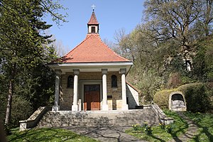
Ahden is one of the oldest settlements in the Almetal. It was mentioned for the first time in 1177. Old maps and records indicate that Ahden was already in the 8th / 9th centuries. Century existed under the name "Adena". In the following centuries Ahden was mentioned again and again, specifically with the construction of the Kluskapelle in 1433.
Ahden threatened to die out around the year 1500, there were only 30 inhabitants left. In 1647/48 the place including the Kluskapelle was destroyed by Carl Gustav Wrangel in the Thirty Years' War . The chapel was rebuilt in the middle of the village in 1700 and consecrated to Saint Anthony. It was demolished in 1912 and replaced by the current parish church . Ahden has belonged to the parish of Brenken for centuries, which has existed since 835. In 1921 Brenken was removed, in 1922 the Ahden parish church of St. Antonius got new bells and in 1927 a new organ. In 1933 a new Kluskapelle was built in Ahden.
Ahden has always been a village that lived from agriculture and cattle breeding. The craft was little represented here.
In 1898 the Paderborn – Büren railway line was inaugurated with a train station in Ahden. As early as 1974, rail operations in the northern area of the Almetalbahn with Ahden were stopped. At the end of the 1960s, plans for the Paderborn / Lippstadt regional airport to the west of Ahden were implemented and, in the early 1970s, federal motorway 44 was built south of Ahden.
After the Second World War , a vigorous reconstruction was undertaken in Ahden. This is how the Sieksberg housing estate came into being at the end of the 1950s and the Winkelfeld estate at the end of the 1960s. A new school was built in 1955 after there had been two schools - namely a boys 'and a girls' school - for almost 150 years. A new home has also been created for Ahden clubs. The shooting club built a new hall - the "Hellweghalle". So the BSV Ahden often changed its place until it found its home in today's Hellweghalle.
The volunteer fire brigade built a fire station in 1965 , which was replaced in 2003 by a more contemporary one with a training room and a larger vehicle hall at the Hellweghalle.
The place has not been independent since January 1, 1975, but belongs to the city of Büren.
politics
The mayor is Rainer Fischer (SPD). The city council members are Roland Hüser (CDU) and Peter Salmen (SPD).
economy
The Paderborn / Lippstadt airport is on Ahdener area and is the largest employer. Next to the airport, agriculture is the largest industry. Thus, the district fire brigade headquarters of the Paderborn district has also found its base in Ahden at the airport. In addition, the federal police, customs and the police in Ahden are represented at the airport.
A commercial area has developed around the airport, which offers space for a wide variety of companies.
Web links
- Ahden website
- Ahden in the Westphalia Culture Atlas
Individual evidence
- ↑ Stadtspiegel of the city of Büren, issue No. 178, page 4: Population development 2019 from March 7, 2020.
- ^ Geographical Commission for Westphalia (ed.): Geographisch-Landeskundlicher Atlas von Westfalen, Topic X Administration and Management, double sheet state and municipal administrative structure , Münster 1990.
- ^ Federal Statistical Office (ed.): Historical municipality directory for the Federal Republic of Germany. Name, border and key number changes in municipalities, counties and administrative districts from May 27, 1970 to December 31, 1982 . W. Kohlhammer, Stuttgart / Mainz 1983, ISBN 3-17-003263-1 , p. 320 .


