Weibersbach (Kahl, Schimborn)
|
Weibersbach Historically : Daxberger Bach |
||
| Data | ||
| location |
Spessart
|
|
| River system | Rhine | |
| Drain over | Kahl → Main → Rhine → North Sea | |
| source | east of Daxberg 50 ° 2 ′ 31 ″ N , 9 ° 10 ′ 32 ″ E |
|
| Source height | 267 m above sea level NHN | |
| muzzle | in Schimborn in the Kahl coordinates: 50 ° 3 ′ 25 ″ N , 9 ° 11 ′ 18 ″ E 50 ° 3 ′ 25 ″ N , 9 ° 11 ′ 18 ″ E |
|
| Mouth height | 174 m above sea level NHN | |
| Height difference | 93 m | |
| Bottom slope | 40 ‰ | |
| length | 2.3 km | |
| Catchment area | 1.8 km² | |
| Flowing lakes | Milchgrundweiher | |
The Weibersbach is a left tributary of the Kahl in the district of Aschaffenburg in the Bavarian Spessart .
geography
course
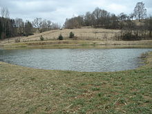
The Weibersbach, also known historically as the Daxberger Bach , rises east of Daxberg in the Milchgrund near the Froschmaul . Part of the women Bach fed together with the source of the Shepherd reason built in 2000 milk base pond . The course of this pond flows back into the Weibersbach . It runs north-east on the eastern slope of the Glasberg , is fed by other sources and reaches Schimborn . There the Weibersbach flows between the houses, crosses under the 2305 state road and runs to the “old mill”. The Weibersbach flows there below the Feldkahl into a left arm of the Kahl .
Kahl river system
See also
Web links
Commons : Weibersbach (Schimborn) - Collection of images, videos and audio files

