
Weinsfeld (Prüm)
|
Weinfeld
City of Prüm
Coordinates: 50 ° 11 ′ 32 ″ N , 6 ° 22 ′ 3 ″ E
|
||
|---|---|---|
| Height : | 435 m above sea level NHN | |
| Residents : | 238 (June 1, 2014) | |
| Incorporation : | 1st January 1973 | |
| Postal code : | 54595 | |
| Area code : | 06551 | |
Location of Weinsfeld in Rhineland-Palatinate |
||

_02.jpg)
Weinsfeld is a district of the city of Prüm in the Eifelkreis Bitburg-Prüm in Rhineland-Palatinate .
location
Weinsfeld is located in the Prüm valley , which runs south of the village. The two district roads 111 and 195 run through the village. Federal highway 60 runs east of the village . Neighboring places are Steinmehlen in the north and Watzerath in the south .
history
Weinsfeld was first mentioned in a document in 1282. During excavations, Franconian grave fields were discovered, which means that people lived in Weinsfeld as early as the 8th century. This is also indicated by a deed of foundation by Bertrada von Mürlenbach from the 8th century, because it mentions a Winard farm. A church for Weinsfeld is mentioned for the first time in 1570.
On January 1, 1973, the previously independent municipality of Weinsfeld was incorporated into the city of Prüm.
Attractions
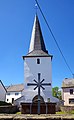
- The Roman Catholic branch church of St. Leonhard (bell tower from 1735, nave from approx. 1961)
Alt - St. Leonhard

new church (1961)
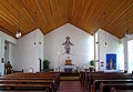
inner space
Nave with gallery

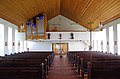
organ
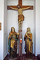
Crucifixion group
_05.jpg)
_07.jpg)
_09.jpg)
_16.jpg)
_17.jpg)
_12.jpg)
Population development
| year | Residents |
|---|---|
| 1933 | 196 |
| 1939 | 183 |
| 2014 | 238 |
Web links
Individual evidence
- ^ Carolingian city of Prüm. Verbandsgemeinde Prüm, accessed on September 10, 2015 .
- ^ Entry on St. Leonhard (Weinsfeld) in the database of cultural assets in the Trier region ; accessed on March 11, 2016.
- ↑ Official municipality directory (= State Statistical Office of Rhineland-Palatinate [Hrsg.]: Statistical volumes . Volume 407 ). Bad Ems February 2016, p. 176 (PDF; 2.8 MB).
- ^ Michael Rademacher: German administrative history from the unification of the empire in 1871 to the reunification in 1990. County of Prüm. (Population figures with sources on private website; online material for the dissertation, Osnabrück 2006).

Dausfeld | Niederprüm | Prüm | Stone flour | Blackboard | Walcherath | Weinsfeld | Vortex separation