Wesendahl
|
Wesendahl
City of Altlandsberg
Coordinates: 52 ° 36 ′ 1 ″ N , 13 ° 48 ′ 49 ″ E
|
|
|---|---|
| Height : | 75 m above sea level NHN |
| Area : | 65 ha |
| Incorporation : | December 31, 2002 |
| Postal code : | 15345 |
| Area code : | 03341 |
Wesendahl is a district of the town of Altlandsberg in the Märkisch-Oderland district in Brandenburg .
geography
The place is located 13 kilometers northeast of Altlandsberg. The neighboring towns are Stadtstelle in the north, Prötzel in the northeast, Kähnsdorf in the east, monastery village and provincial settlement in the southeast, Roter Hof in the south, Gartenstadt in the southwest, Gielsdorf in the west and Eichenbrandt , Heidekrug and Lattbusch forestry in the northwest.
Attractions
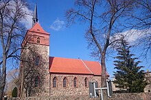
The Wesendahl village church is a late Romanesque stone church that was probably built in the 13th century. The structure survived the Second World War largely undamaged. In 1946, however, the incumbent mayor ordered the roofs of the nave and tower to be covered so that the roof tiles could be used for repair work on other buildings. This caused the building to deteriorate and the church was in ruins in the late 1940s . The parish used the choir as a makeshift church. Only long after the fall of the Wall was the building rebuilt and restored between 2001 and 2010 with the support of a development association.
Web links
- Wesendahl in the genealogical index of places
- Kultur-GUT and Sport e. V. Wesendahl
Individual evidence
- ^ City of Altlandsberg - districts according to § 45 municipal constitution - inhabited districts - living spaces. Ministry of the Interior and Local Affairs of the State of Brandenburg, accessed on September 22, 2016 .
- ↑ BrandenburgViewer of the state survey and geographic base information Brandenburg (LGB)
- ↑ The village church of Wesendahl (district of Märkisch-Oderland) , website of the support group for old churches Berlin-Brandenburg, originally published in the Märkische online newspaper on September 25, 2017
