Westerbach (hazel)
| Westerbach | ||
|
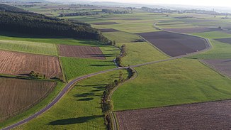
The Westerbach near Eppishausen |
||
| Data | ||
| Water code | DE : 1165122 | |
| location | Germany , Bavaria | |
| River system | Danube | |
| Drain over | Hasel → Mindel → Danube → Black Sea | |
| source | north of Tussenhausen , district of Unterallgäu 48 ° 6 ′ 50 ″ N , 10 ° 34 ′ 18 ″ E |
|
| Source height | approx. 628 m above sea level NN | |
| muzzle | near Haselbach (municipality Eppishausen , district Unterallgäu) in the Hasel coordinates: 48 ° 12 ′ 20 ″ N , 10 ° 30 ′ 13 ″ E 48 ° 12 ′ 20 ″ N , 10 ° 30 ′ 13 ″ E |
|
| Mouth height | approx. 524 m above sea level NN | |
| Height difference | approx. 104 m | |
| Bottom slope | approx. 8.5 ‰ | |
| length | 12.3 km | |
| Communities | Tussenhausen , Kirchheim in Swabia and Eppishausen | |
The Westerbach is a left tributary of the Hasel in the Unterallgäu district . About this and the Mindel it is an indirect right tributary of the Danube in Bavaria .
The source of the Westerbach is north of Tussenhausen near the district road MN 23 (Tussenhausen - Markt Wald ). From there, the 12 km long Westerbach flows first in a north-westerly and then in a northerly direction to the confluence with the Hasel near Haselbach (municipality of Eppishausen ). The difference in altitude between the source and the mouth is 104 m. The Westerbach flows on the southwestern edge of the Augsburg-Westliche Wälder nature park . The Westerbach does not flow through any villages.
Individual evidence
- ↑ Bavarian State Office for the Environment ( Memento of the original from April 9, 2005 in the web archive archive.today ) Info: The archive link has been inserted automatically and has not yet been checked. Please check the original and archive link according to the instructions and then remove this notice.
