
Weststadt (Göttingen)


The Weststadt is one of the 18 districts in Göttingen . It is located northwest of the city center and is bordered by the railway systems to the east. To the west and south it goes over to Grone , in the north to Holtensen , the border corresponds to the municipal boundaries before the incorporation of Grone and Holtensen. The western part of the city extends from the large housing estate "Holtenser Berg" in the north via Hagenberg and Egelsberg to the old city cemetery in the south and from the western side of the station to the industrial area of Göttingen. The line runs through the eastern part of the west town.
Most of the western part of the city, which was not built until the 20th century, is characterized by rental apartments, smaller homes and businesses. At the end of 2018, 13,462 people lived here.
history

The royal palace of Grona, first mentioned in 915, stood on the southwest end of the Hagenberg . In the first half of the 11th century it was one of the most important Palatinates in Germany, in 1024 Emperor Heinrich II died here . The farms that supplied the Palatinate were about three kilometers to the south and were a nucleus of the district of Grone. They were connected to the Palatinate via the "Königsstieg". In the following centuries the Palatinate lost its importance. Like other aristocratic residences in the area, it was feuded several times in the 14th century by the citizens of the up-and-coming Hanseatic city of Göttingen and finally destroyed in 1386.
The area of today's Weststadt served primarily as pastureland until the 19th century. At the end of the 19th century, the previously bare Hagenberg was reforested.
After the Hanover – Kassel railway was built, a workshop was built west of the station, which was expanded into a repair shop in the following years . This also included the locomotive hall .
In the 1930s, a military airfield was created in the current industrial area, and the Hagenberg was also a restricted area as a military training area. A settlement was built on the Pfalz-Grona-Breite for officer families and civil employees.
After the Second World War, Göttingen had to take in a large number of displaced persons, the number of inhabitants rose from around 52,000 (1937) to 78,000 (1950). The previous military areas were turned into building land, until around 1952 mostly simple apartments were built, including the blocks of the housing cooperative on the Hagen, the buildings on the Pfalz-Grona-Breite and the Egelsberg were densified. In the new parts of the city, for the construction of which funds from the Marshall Plan were used, mostly displaced people lived, while southern Lower Saxony was in the minority.
In 1968 the first residents moved into the large housing estate "Holtenser Berg".
After the electrification of the north-south line in 1963, the repair shop lost its function. The area on the west side of the station could be redesigned, a school center was created here (Otto Hahn Gymnasium, vocational schools, adult education center). The locomotive hall fell into disrepair until it was converted into a large cinema and event hall in 1998.
religion
Ev.-luth. Christ Church on the Egelsberg

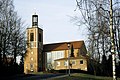
Ev.-luth. Friedenskirche on the Hagenberg

Mosque on Königsstieg


The area of the Weststadt belonged to the parish of St. Mary's Church in the city center until the early 1950s . From there in 1951 the Christ and Peace Churches were spun off. Both churches were designed by the architect Diez Brandi in the style typical of the time. The Bethlehem Congregation on the Holtenser Berg was separated from the Peace Community in 1986. As the number of parishioners is declining, these three parishes increasingly appear together as "the western city parishes".
The Roman Catholic Church is represented by the Godehard Church.
The DITIB opened a representative mosque on Königsstieg in 2006 . The inconspicuous mosque on Maschmühlenweg was taken over by a smaller mosque association .
Individual evidence
- ↑ Overview map of the city structure at https://duva-stg-extern.kdgoe.de/Informationsportal/Dateien/019.01K-2017.pdf (PDF)
- ↑ https://duva-stg-extern.kdgoe.de/Informationsportal/Dateien/020.30-2018.pdf
- ↑ Gerhard Mercker: It began in 1952 - an evangelical church congregation through the ages , 2nd edition, Friedensgemeinde Göttingen 2006, without ISBN, p. 14f
Deppoldshausen | Elliehausen | Esebeck | Geismar | Grone | Gross Ellershausen | Herberhausen | Hetjershausen | Holtensen | Downtown | Knutbühren | Nikolausberg | Nordstadt | Oststadt | Ring | Südstadt | Turn | West town
Coordinates: 51 ° 33 ′ 2.6 " N , 9 ° 54 ′ 44.2" E