Wetzlarer Hintertaunus
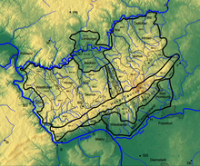
The Wetzlarer Hintertaunus is a natural area in southern Central Hesse . It is part of the main unit 302 ( Eastern Taunus ) and has the code number 302.0. It is bordered to the north by the Lahn valley , to the west by the Solmsbach and to the east by the Kleebach or the Großenlindener Hügelland , which, like the Lahn valley in the north, is part of the Giessen basin .

Limits
The headwaters of the two surrounding rivers Solmsbach and Kleebach in the south near Espa and Weiperfelden are already included in the somewhat more montane neighboring natural area of Bodenroder Kuppen , while the upper reaches of the Kleebach between Cleeberg and Oberkleen already belong to the Wetzlarer Hintertaunus. From the last-mentioned place, the eastern border stretches in a fairly precise south-north direction towards the Lahn.
Natural location
- 302 Eastern Hintertaunus
- 302.2 Wetzlarer Hintertaunus (165.88 km²)
places
Almost all localities in the natural area belong to the Lahn-Dill district . The cities of Wetzlar (east) and Solms (west) occupy the north . To the south, the communities Hüttenberg adjoin Wetzlar and Schöffengrund adjoin Solms. In the west is the Braunfels district of Bonbaden , in the southwest some districts of the municipality of Waldsolms .
To district casting simply count since the regional reorganization in 1978 (previously Kreis Wetzlar / Lahn-Dill district), the two places Cleeberg and Oberkleen (both community Langgöns ) in the extreme southeast and a size as to be neglected wooded area on the border casting about Wetzlar in the Northeast .
Rivers
In addition to the right Somsbach and left Kleebach tributaries, the Wetzbach, which rises in the southern center of the natural area around the Köhlerberg, divides the north into an east and a west half. The Kleebach tributary Schwingbach , which flows to the northeast, also rises in its source region .
mountains
- Schorn (approx. 450 m), extreme south
- Köhlerberg (424.7 m), southern center
- Stoppelberg (401.2 m), Wetzlarer Stadtberg with an observation tower in the north
swell
- Federal Agency for Nature Conservation
- Environmental Atlas Hesse
- map
- Description (natural area 302.0)
Individual evidence
- ↑ Map ( Taunus & Gießen-Koblenzer Lahntal ) and legend ( Taunus ) - attention: web links without return! - Environmental Atlas Hessen of the Hessian State Office for Environment and Geology: The natural areas of Hesse and their main units
Coordinates: 50 ° 30 ' N , 8 ° 31' E