
Bon bathing
|
Bon bathing
City of Braunfels
|
|
|---|---|
 |
|
| Height : | 170 m above sea level NHN |
| Area : | 7.15 km² |
| Residents : | 1510 (June 30, 2019) |
| Population density : | 211 inhabitants / km² |
| Incorporation : | December 31, 1971 |
| Postal code : | 35619 |
| Area code : | 06442 |
 Location of Bonbaden in Braunfels
|
|
Bonbaden is a district of the central Hessian town of Braunfels in the Central Hessian Lahn-Dill district .
geography
location

Bonbaden is embedded in the Solmsbachtal , which runs in a north-south direction. In the village the Hainbach, which rises near Laufdorf, flows into the Solmsbach from the east . Bonbaden belongs to the eastern Hintertaunus and forms the western border of the Wetzlarer Hintertaunus . The village is surrounded by several forest areas, only in the south and northeast are several fields that are used for agriculture today. Furthermore, Bonbaden is located on the northern edge of the Taunus Nature Park . The next big city is Wetzlar .
geology
In the area around Bonbaden, there are mainly sedimentary rocks such as Grauwacken from the Devonian and Carboniferous . During the Devonian one close to the covered equatorial located tropical sea place. The area is characterized by diabase and ore deposits due to active volcanism . At the end of the Devonian, the sea closed between the continents Gondwana and Laurussia , from which the Variscan Mountains emerged when they collided . This is the basis of today's European Central Mountains and also extended over the time still with Europe connected North America . The resulting slate was often used as a material for facade cladding and roofs, which can still be seen on some houses in Bonbaden today. The material of more recent times was almost completely eroded by the unfolding during the formation of the mountains.
The few fossils that can be found are mostly marine , fossilized trilobites . After a collision of the African with the European plate in the New Earth Era, volcanism occurred again in addition to the formation of the Alps in Central Europe. Basaltic magma formations such as the Burgberg von Braunfels and the Stoppelberg in Wetzlar date from this time . Another impact is the occurrence of mineral water , for example in Schwalbach . From the Pleistocene are loess and loess present.
Source:
history

The settlement of Bonbaden can be traced back to the Latène period when the western slopes of the Solmsbach were used as agricultural terraces .
The village was first mentioned in a document as Banamaden 772 and Banamatha 778 in the Lorsch Codex . This makes Bonbaden one of the oldest settlements in the old district of Wetzlar . In the post-Carolingian period, the place was located on an important ford of the “Strata publica” that connected Wetzlar with Weilburg .
Because of the overpopulation in the empire, many citizens emigrated to Russia . On July 21, 1766, 17 Bonbaden residents, 6 adults and 11 children also immigrated. In 1804 17 other citizens emigrated to the USA . In 1852 eight people from Bonbaden followed, eleven citizens with New York as their destination in 1853 and another four in 1854.
Bonbaden belonged to the county of Solms and therefore came under Prussian rule at the beginning of the 19th century, where it was subordinated to the mayor's office of Braunfels. From 1841 Bonbaden was administered by the local mayor's office of Schöffengrund . In 1961 the municipality of Bonbaden entered into a partnership with Rohrmoos-Untertal (Styria).
As part of the regional reform in Hesse , on December 31, 1971, the communities of Bonbaden, the city of Braunfels and other previously independent communities merged on a voluntary basis to form the city of Braunfels. The community partnership was transferred to Braunfels.
In August 1981 a summer flood of the Solmsbach flooded the place and caused severe damage. Heavy thunderstorms after a long period of drought caused the Bonbaden gauge to climb to its previous high of 2.75 meters on August 11, 1981.
Historical forms of names
In documents that have survived, Bonbaden was mentioned under the following place names (the year it was mentioned in brackets):
- Banamades, in villa (772/3) [2. Half of the XII century, Codex Laureshamensis III, No. 3139 = 3687c]
- Banemaden, in villa (772/3) [2. Half of the XII century, Codex Laureshamensis III, No. 3139 = 3687c]
- Banamatha, in villa (778) [2. Half of the XII century, Codex Laureshamensis III, No. 2999 = 3697]
- Banamada, in villa (778) [2. Half of the XII century, Codex Laureshamensis III, No. 2999 = 3697]
- Banamada, in loco (779-790) [2. Half of the XII century, Codex Laureshamensis III, No. 3063 = 3699a]
- Banamaden, in villa (779–790) [2. Half of the XII century, Codex Laureshamensis III, No. 3063 = 3699a]
- Banamaden, in villa (779–790) [2. Half of the XII century, Codex Laureshamensis III, No. 3140 = 3706c]
- Banamaden, in (779-790) [2. Half of the XII century, Codex Laureshamensis III, No. 3140 = 3706c]
- Banamades, in villa (790) [2. Half of the XII century, Codex Laureshamensis III, No. 3138 = 3710 b]
- Banemaden, in (790) [2. Half of the XII century, Codex Laureshamensis III, No. 3138 = 3710 b]
- Bombades [map of the Wetzlar district]
Jewish community
There is evidence that Jewish residents have lived in Bonbaden since the 17th century. However, there were no religious buildings in the village, such as a cemetery or synagogue. The Bonbaden Jews went to the synagogue in Braunfels and were buried in Burgsolms . The Jewish children attended the local elementary school. From 1853, Bonbaden belonged to the Jewish community of Wetzlar as a branch community . Around 1900 the proportion of the population with 32 Jewish citizens was 4.9%. During the National Socialist era , three families fled to the USA and one to Great Britain . 12 Jews were deported eastwards in the summer of 1942. The transport took place on June 12, 1942 from the Wetzlar train station via Frankfurt am Main to the Sobibor and Majdanek extermination camps . On August 28, 1942, a Jewish citizen came to the Treblinka extermination camp on the second transport .
Territorial history and administration
The following list gives an overview of the territories in which Bonbaden was located and the administrative units to which it was subordinate:
- 772/3: Lahngau ( in pago Logenouue )
- 778: Wettereiba , Wanendorfer Mark ( in pago Wetdereiba in Wizelere marca )
- before 1806: Holy Roman Empire , Principality of Solms-Braunfels , part of the County of Solms , Braunfels office
- from 1806: Duchy of Nassau , Amt Braunfels
- 1816: Kingdom of Prussia , Rhine Province , Region of Koblenz , county Braunfels
- from 1822: Kingdom of Prussia, Rhine Province, Koblenz District, Wetzlar District
- from 1866: North German Confederation , Kingdom of Prussia, Rhine Province, Koblenz District, Wetzlar District
- from 1871: German Empire , Kingdom of Prussia, Rhine Province, Koblenz District, Wetzlar District
- from 1918: German Empire, Free State of Prussia , Rhine Province, Koblenz District, Wetzlar District
- from 1932: German Empire, Free State of Prussia, Province of Hessen-Nassau , Administrative Region of Wiesbaden , District of Wetzlar
- from 1944: German Empire, Free State of Prussia, Nassau Province , Wetzlar District
- from 1945: American zone of occupation , Greater Hesse , Wiesbaden district, Wetzlar district
- from 1949: Federal Republic of Germany , State of Hesse , Wiesbaden district, Wetzlar district
- from 1968: Federal Republic of Germany, State of Hesse, administrative district Darmstadt , district of Wetzlar
- on December 31, 1971 Bonbaden was incorporated as a district of the city of Braunfels.
- from 1977: Federal Republic of Germany, State of Hesse, Darmstadt administrative district, Lahn-Dill district
- from 1981: Federal Republic of Germany, State of Hesse, Gießen administrative district , Lahn-Dill district
population
Population development
| Bonbaden: Population from 1834 to 1970 | ||||
|---|---|---|---|---|
| year | Residents | |||
| 1834 | 370 | |||
| 1840 | 448 | |||
| 1846 | 466 | |||
| 1852 | 497 | |||
| 1858 | 531 | |||
| 1864 | 550 | |||
| 1871 | 595 | |||
| 1875 | 611 | |||
| 1885 | 662 | |||
| 1895 | 649 | |||
| 1905 | 695 | |||
| 1910 | 789 | |||
| 1925 | 783 | |||
| 1939 | 800 | |||
| 1946 | 1,057 | |||
| 1950 | 1,212 | |||
| 1956 | 1,327 | |||
| 1961 | 1,364 | |||
| 1967 | 1,534 | |||
| 1970 | 1,559 | |||
| Data source: Historical municipality register for Hesse: The population of the municipalities from 1834 to 1967. Wiesbaden: Hessisches Statistisches Landesamt, 1968. Other sources: | ||||
Religious affiliation
Source: Historical local dictionary
- 1834: 355 Protestant and 15 Jewish residents
- 1961: 953 Protestant, 402 Roman Catholic residents
politics
Local advisory board
There is a local advisory board with a local mayor for Bonbaden . The local advisory council consists of five members, four of which are from the SPD and one from the CDU since the local elections in Hesse in 2016 . The mayor is Ingo Habermann (SPD).
coat of arms
On October 23, 1968, the municipality of Bonbaden in what was then the district of Wetzlar was given a coat of arms with the following blazon by the Hessian Minister of the Interior : In blue between a golden hammer with mallet and a gold star, a silver sloping bar, topped with three blue diamonds.
The municipal coat of arms of Bonbaden goes back to Johann von Banewaden . The Wetzlar citizen and lay judge sealed a certificate with his coat of arms in December 1432.
Culture and sights
societies
There is a very active club life in the village. The largest sports club is the TuS Bonbaden, followed by the TC Bonbaden. This has existed since November 24, 1977 and today has a three-seat facility and 166 active members.
Regular events
The cultural highlight is the Bonbaden open-air stage , where two plays for children and an evening play for adults are performed every year in summer. It was built in 1951/1952 on a filled up mine dump on the western edge of the village.
Buildings
Protestant church
The Protestant church was built around the year 1000 and is located on a small hill on the northern edge of the village. It was built as a fortified church with a presumably late Romanesque choir tower and hipped roof . On the east wall in the interior is the baroque pulpit and the organ from Möttau, created in 1891 . The north wall of the choir has both late Romanesque and late Gothic wall paintings with saints, which were only discovered in 1986 during the most recent renovation after a 3 cm thick layer of plaster was removed. Four stained glass by the Evangelists are also still preserved. These were donated by Albert Hoffmann to the Bonbaden parish as thanks for the loving care of his grave for his father.
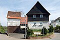
Bonbaden half-timbering
The town center development around Hauptstrasse and Schulstrasse is a listed building as a whole . Eight half-timbered houses are designated as cultural monuments within the entire complex . Further half-timbered houses are located on Am Kirchberg as well as in Neukirchener Strasse and Laufdorfer Strasse . After a major fire destroyed large parts of the village in 1846, around 20 half-timbered houses have been preserved. The oldest half-timbered house probably dates from the 17th century. The construction method was influenced by the Hüttenberger Land . There are two typical “Hüttenberger farm gates” in the main street .

Evangelical village church
Single monument Am Kirchberg 2, late 18th century

Half-timbered house with Winkelhof

Old school from 1836/37

Half-timbered houses

Courtyard gate from 1785, Hauptstr. 23

bakery


Economy and Infrastructure
Industry and commerce
After the Second World War, a dye works and dry cleaning company , the Lahmann & Co. company , was established on the outskirts . In the 1950s, 250 people were employed, making the company the largest employer in the village. Due to the textile imports, the company went bankrupt in July 1977. In addition, a brick factory was built in the post-war period and, at the end of the 1960s, the Bonbadener Maschinenbau .
traffic
The L 3283 runs through Bonbaden and runs from Solms-Oberndorf in the north to Neukirchen in the south. It forms the main street of the village and is run as Solmsbachstraße and Neukirchener Straße . In addition, the K 373 branch off to Laufdorf and the K 374 to Schwalbach (both villages belong to the municipality of Schöffengrund ).
On November 1, 1912, the Solmsbach Valley Railway was opened. In Bonbaden there was a stop and thus a connection to the rail network of the Prussian State Railways . With the shutdown of passenger traffic on the line on May 31, 1985 and the dismantling of the tracks, the stop was also closed. Today the final stop of the Taunusbahn is in Brandoberndorf, 12 kilometers away . For this purpose, a rail replacement service with buses has been set up, which provides a connection to the Taunusbahn for Bonbaden.
Public facilities
Bonbaden has a volunteer fire brigade that was founded in 1930. Before that there was already a compulsory fire brigade in town. The fleet includes a fire fighting group vehicle 16-TS, a portable pump vehicle with a water tank, a tank fire engine 8/8 for civil protection and a team transport vehicle .
In Bonbaden there is a primary school , a kindergarten and a multi-purpose hall . There is also a Protestant and a Catholic church in the village.
personality
- Karl Allmenröder (1828–1912), Protestant clergyman and archivist
literature
- Magistrate of the city of Braunfels (Ed.): Chronicle Bonbaden ( A village on Solmsbach ). Heimatfreunde Bonbaden and the Bonbaden Chronicle Working Group, 1st edition 2007
- Literature on Bonbaden in the Hessian Bibliography
Web links
- Bonbaden district on the website of the city of Braunfels.
- Bonbaden, Lahn-Dill district. Historical local dictionary for Hessen. In: Landesgeschichtliches Informationssystem Hessen (LAGIS).
- State Office for Monument Preservation Hessen (Ed.): Entire facility Bonbaden In: DenkXweb, online edition of cultural monuments in Hessen
Individual evidence
- ↑ a b Statistical data Bonbaden. In: Internet presence. City of Braunfels, accessed May 8, 2020 .
- ^ Village chronicle / 1.1 Geology of our homeland, pp. 1–3
- ↑ Village Chronicle / 12.2 Emigration to the Volga and the USA, pp. 452–467
- ↑ Gerstenmeier, K.-H. (1977): Hessen. Municipalities and counties after the regional reform. A documentation. Melsungen. P. 284
- ↑ Extreme floods in the last few decades in the Gießen administrative district ( Memento from May 14, 2011 in the Internet Archive ), accessed on February 14, 2009
- ↑ Bonbaden / Solmsbach gauge ( memento from June 20, 2007 in the Internet Archive ), accessed on February 14, 2009
- ↑ a b c d Bonbaden, Lahn-Dill district. Historical local dictionary for Hessen. (As of March 23, 2018). In: Landesgeschichtliches Informationssystem Hessen (LAGIS).
- ^ Village chronicle / 4.2 Jewish citizens in Bonbaden, pp. 185–186
- ^ Michael Rademacher: German administrative history from the unification of the empire in 1871 to the reunification in 1990. State of Hesse. (Online material for the dissertation, Osnabrück 2006).
- ↑ Wilhelm von der Nahmer: Handbuch des Rheinischen Particular-Rechts: Development of the territorial and constitutional relations of the German states on both banks of the Rhine: from the first beginning of the French Revolution up to the most recent times . tape 3 . Sauerländer, Frankfurt am Main 1832, OCLC 165696316 , p. 250 ( online at google books ).
- ↑ Bonbaden local advisory board on the website of the city of Braunfels, accessed in February 2017.
- ↑ Approval of a coat of arms for the municipality of Bonbaden, Wetzlar district, Darmstadt administrative district of October 23, 1968 . In: The Hessian Minister of the Interior (ed.): State Gazette for the State of Hesse. 1968 No. 46 , p. 1695 , point 1316 ( online at the information system of the Hessian state parliament [PDF; 3.7 MB ]).
- ^ Village chronicle / 1.8 Migration to Wetzlar: "City air makes you free", p. 35
- ↑ Dorfchronik / 15:13 The tennis club Bonbaden
- ↑ About us: from the rubble and overburden dump to the modern forest stage. Bonbaden open-air stage, accessed on February 24, 2020 .
- ^ State Office for the Preservation of Monuments Hesse (ed.): Am Kirchberg 1 In: DenkXweb, online edition of cultural monuments in Hesse
- ^ Village chronicle / 2.1 The old village church of Bonbaden, pp. 59–63
- ↑ Dorfchronik / 4.9 Bonbadener Fachwerk, pp. 269–275
- ↑ Village Chronicle / 15.6 Voluntary Fire Brigade pp. 546–555
