
Tiefenbach (Braunfels)
|
Tiefenbach
City of Braunfels
|
|
|---|---|
 |
|
| Height : | 151 m above sea level NHN |
| Area : | 7.2 km² |
| Residents : | 1081 (Dec. 31, 2019) |
| Population density : | 150 inhabitants / km² |
| Incorporation : | December 31, 1971 |
| Postal code : | 35619 |
| Area code : | 06473 |
 Location of Tiefenbach in Braunfels
|
|
Tiefenbach is a district of Braunfels in the Lahn-Dill district in Central Hesse .
Geographical location
The place is located in the northern foothills of the Taunus , northwest of the core city of Braunfels and not far from the Lahn . Tiefenbach lies in a valley that is partially surrounded by forest. The Lindelbach rises in the Tiefenbach district and flows through the village in pipes and flows northwest into the Lahn not far from the settlement boundary . The next larger city is Wetzlar , which is about 14 kilometers away.
history
_Ansichtskarte.png)
Tiefenbach was first mentioned as Difenbach in 1245 , when Count Heinrich I von Solms bought his property in the village from the noble Volpert von Gemünden. This first mention is also that of the city of Braunfels, as the name Brunenvelß was also mentioned for the first time in the negotiation .
During the Thirty Years War the place was invaded by Spanish (1621) and imperial (1622), as well as (1634) by Swedish troops, the residents were robbed. Towards the end of the Thirty Years' War, the village was finally no longer inhabited because the inhabitants had fled to Braunfels.
Territorial reform
The independent municipality of Tiefenbach was incorporated into the city of Braunfels on December 31, 1971 as part of the regional reform in Hesse .
Territorial history and administration
The following list gives an overview of the territories in which Tiefenbach was located and the administrative units to which it was subordinate:
- before 1806: Holy Roman Empire , Principality of Solms-Braunfels , part of the County of Solms , Braunfels office
- from 1806: Duchy of Nassau , Amt Braunfels
- 1816: Kingdom of Prussia , Rhine Province , Region of Koblenz , county Braunfels
- from 1822: Kingdom of Prussia, Rhine Province, Koblenz District, Wetzlar District
- from 1866: North German Confederation , Kingdom of Prussia, Rhine Province, Koblenz District, Wetzlar District
- from 1871: German Empire , Kingdom of Prussia, Rhine Province, Koblenz District, Wetzlar District
- from 1918: German Empire, Free State of Prussia , Rhine Province, Koblenz District, Wetzlar District
- from 1932: German Empire, Free State of Prussia, Province of Hessen-Nassau , Administrative Region of Wiesbaden , District of Wetzlar
- from 1944: German Empire, Free State of Prussia, Nassau Province , Wetzlar District
- from 1945: American zone of occupation , Greater Hesse , Wiesbaden district, Wetzlar district
- from 1949: Federal Republic of Germany , State of Hesse , Wiesbaden district, Wetzlar district
- from 1968: Federal Republic of Germany, State of Hesse, administrative district Darmstadt , district of Wetzlar
- on December 31, 1971 Tiefenbach was incorporated as a district of the city of Braunfels.
- from 1977: Federal Republic of Germany, State of Hesse, Darmstadt administrative district, Lahn-Dill district
- from 1981: Federal Republic of Germany, State of Hesse, Gießen administrative district , Lahn-Dill district
population
Population development
| Tiefenbach: Population from 1834 to 1970 | ||||
|---|---|---|---|---|
| year | Residents | |||
| 1834 | 426 | |||
| 1840 | 503 | |||
| 1846 | 567 | |||
| 1852 | 579 | |||
| 1858 | 560 | |||
| 1864 | 609 | |||
| 1871 | 616 | |||
| 1875 | 625 | |||
| 1885 | 639 | |||
| 1895 | 695 | |||
| 1905 | 703 | |||
| 1910 | 724 | |||
| 1925 | 805 | |||
| 1939 | 837 | |||
| 1946 | 1,099 | |||
| 1950 | 1,041 | |||
| 1956 | 1.006 | |||
| 1961 | 977 | |||
| 1967 | 1,033 | |||
| 1970 | 1,039 | |||
| Data source: Historical municipality register for Hesse: The population of the municipalities from 1834 to 1967. Wiesbaden: Hessisches Statistisches Landesamt, 1968. Other sources: | ||||
Religious affiliation
Source: Historical local dictionary
| • 1834: | 409 Protestant and 17 Jewish residents |
| • 1961: | 899 Protestant (= 92.02%), 65 Roman Catholic (= 6.65%) residents |
politics
For Tiefenbach there is a local advisory board with a local mayor . The local advisory council consists of five members, two of which are from the SPD and two from the CDU since the local elections in Hesse in 2016 . The mayor is Ute Dietrich (non-party).
Culture and sights
Viticulture
Wine has been grown again in Tiefenbach since 1994. The vineyard is located in south-facing slope on the outskirts and belongs to Großlage Lahntal in wine region Middle Rhine .
Buildings

Tiefenbacher Kirche (old fortified church ), on the left the oldest school in town (used as such from 1684–1847)
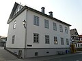
Former school

Baroque portal decoration on the church: alliance coat of arms of the year 1714 of the count couple Wilhelm Moritz zu Solms-Braunfels and Magdalene Sophie, a born landgrave of Hessen-Homburg

Half-timbered houses in Mittelstrasse


traffic
The place is near the federal highway 49 and has its own exit. It can be reached via the K 380 , which is also the main road from Tiefenbach and is there as the Neue Kreisstraße and Am Hühnerberg . It continues to the southeast and after about 5 kilometers leads to the L 3451 on the western edge of the core town of Braunfels. The closest train station is in neighboring Leun-Stockhausen .
Personalities
- Gerhard Bökel (* 1946) lived in Tiefenbach as Hessian interior minister and Hessian SPD parliamentary group and state chairman
- Manuel Possible (* 1979), journalist and documentary filmmaker, grew up in Tiefenbach
Web links
- Tiefenbach district. In: Website of the city of Braunfels.
- Tiefenbach, Lahn-Dill district. Historical local dictionary for Hessen. In: Landesgeschichtliches Informationssystem Hessen (LAGIS).
- Literature on Tiefenbach in the Hessian Bibliography
Individual evidence
- ↑ a b Statistical data Tiefenbach. In: Internet presence. City of Braunfels, accessed May 8, 2020 .
- ↑ Cop. XV. Jh. Lich, Red Book fol. 202 v, cf. on this Solms documents 1 p. XII. Illustration in: Tiefenbacher Chronik p. 13
- ^ Federal Statistical Office (ed.): Historical municipality directory for the Federal Republic of Germany. Name, border and key number changes in municipalities, counties and administrative districts from May 27, 1970 to December 31, 1982 . W. Kohlhammer GmbH, Stuttgart and Mainz 1983, ISBN 3-17-003263-1 , p. 380 .
- ↑ a b c Tiefenbach, Lahn-Dill district. Historical local dictionary for Hessen. (As of August 24, 2018). In: Landesgeschichtliches Informationssystem Hessen (LAGIS).
- ^ Michael Rademacher: German administrative history from the unification of the empire in 1871 to the reunification in 1990. State of Hesse. (Online material for the dissertation, Osnabrück 2006).
- ↑ Wilhelm von der Nahmer: Handbuch des Rheinischen Particular-Rechts: Development of the territorial and constitutional relations of the German states on both banks of the Rhine: from the first beginning of the French Revolution up to the most recent times . tape 3 . Sauerländer, Frankfurt am Main 1832, OCLC 165696316 , p. 250 ( online at google books ).
- ↑ Tiefenbach local advisory board on the website of the city of Braunfels, accessed in February 2017.
