Whangamata
| Whangamata | ||
| Geographical location | ||
|
|
||
| Coordinates | 37 ° 12 ′ S , 175 ° 52 ′ E | |
| Region ISO | NZ-WKO | |
| Country |
|
|
| region | Waikato | |
| District | Thames-Coromandel District | |
| Ward | South Eastern Ward | |
| Residents | 3 471 (2013) | |
| height | 2 m | |
| Post Code | 3620 | |
| Telephone code | +64 (0) 7 | |
| Photography of the place | ||
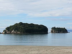
 View of Whangamata |
||
Whangamata is a small town and seaside resort in the Thames-Coromandel District of the Waikato regionon the North Island of New Zealand .
Origin of name
The name of the city means something like "the port of obsidian" in the Māori language . Obsidian is formed when lava is rapidly cooled by water.
geography
The city is located around 30 km southeast of Thames and around 20 km north of Waihi , between Whangamata Harbor on the northern side of the city and the Otahu River as the southern border. To the west of Whangamata , New Zealand State Highway 25 passes north and connects the city with the towns on the eastern coast of the Coromandel Peninsula . Waihi can be reached directly to the south . To the west of the highway rise the mountain peaks of the Coromandel Range between 400 m and around 850 m high .
There are four small islands off the coast. The largest and northernmost island is Hauturu Island , also known as Clark Island , which can be reached by wading over a distance of around 500 m at low tide . It has an extension of 430 m by 280 m. Whenuakura Island , also called Donut Island , is located around 900 m east of the southern part of Whangamata Beach . On the island, which has a size of 236 m by 150 m, there is a large, collapsed sea grotto, which forms a small beach inside the ring-shaped island, hence its alternative name. Until a few years ago, bridge lizards lived on the island . The southern end of the islands is the 120 m by 63 m Rawengaiti Island . The fourth island is only 36 m in diameter and is located between the first two.
population
In the 2013 census, the town had 3471 inhabitants, 2.4% less than in the 2006 census, but the population of the town can rise to around 60,000 over the Christmas period in summer due to the holiday season.
Education
With the Whangamata Area School, the city has a Composit School with grades 1 to 15. In 2017, 435 students attended the school.
tourism
The city has an approximately 3.6 km long beach that stretches over two bays of almost the same size. On the northeast side of Whangamata is the city's marina, which accesses the Pacific Ocean via Whangamata Harbor .
literature
- Helga Neubauer: Whangamata . In: The New Zealand Book . 1st edition. NZ Visitor Publications , Nelson 2003, ISBN 1-877339-00-8 , pp. 244 f .
Web links
- Whangamata . Destination Coromandel,accessed on October 28, 2017(English, commercial website).
Individual evidence
- ↑ a b 2013 Census QuickStats about a place : Whangamata . Statistics New Zealand , accessed October 28, 2017 .
- ^ Neubauer: Whangamata . In: The New Zealand Book . 2003, p. 244 .
- ↑ a b c Topo250 maps . Land Information New Zealand , accessed October 28, 2017 .
- ↑ Measure the position of the four islands and their extent with Google Earth Version 7.3.0.3832.
- ^ Life in a resort town : Whangamata , Coromandel Peninsula . In: Stuff - Destinations . Fairfax Media , January 13, 2017, accessed October 28, 2017 .
- ^ Whangamata School . Education Review Office , accessed October 28, 2017 .


