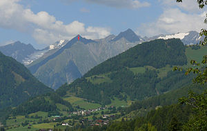
Mullwitzkogel
| Mullwitzkogel | ||
|---|---|---|
|
Mullwitzkogel (red arrow), seen from Zedlach (from the east). |
||
| height | 2767 m above sea level A. | |
| location | East Tyrol , Austria | |
| Mountains | Venediger group | |
| Dominance | 0.4 km → Hochkarkopf | |
| Notch height | 55 m ↓ notch to Hochkarkopf | |
| Coordinates | 47 ° 1 '18 " N , 12 ° 17' 40" E | |
|
|
||
The Mullwitzkogel , also called Wiesbauerspitze , is a 2,767 meter high mountain in the Venediger group . The summit is in the municipality of Prägraten am Großvenediger . The summit achieved fame due to the renaming of the mountain in 2007 after the sausage manufacturer Wiesbauer , which also gave the summit the joke name Wurstberg or Wurstspitze .
history
The community of Prägraten had been a stage of the Tour of Austria since 2006 , the main sponsor of which was the sausage manufacturer Wiesbauer for years. After Wiesbauer had also been active in sponsoring hiking trails and mountain equipment for years, the company organized a competition in 2006 for buyers of its mountaineering sausage in close cooperation with various tourism associations. Prägraten then approached the director of the Wiesbauer company to be named as a region in the competition. After Wiesbauer had promised his cooperation, the community renamed the Mullwitzkogel to Wiesbauerspitze. The resolution was passed unanimously by the local council at the end of March 2007, and the renaming was completed in early July 2007.
The renaming of the summit triggered a lot of media coverage. In the course of the discussion about the legality of the renaming, the constitutional expert of the University of Innsbruck Karl Weber stated that the naming of mountains and field names was based on a centuries-old tradition, but was not subject to any public law restrictions and therefore the name could be determined by the respective owner. However, the Austrian Alpine Association subsequently announced that it would continue to use the name “Mullwitzkogel” in its maps. According to the statements of the Alpine Club, other map manufacturers would also keep the original name.
The renaming also triggered a parliamentary request from the then FPÖ member of the National Council, Gerald Hauser , who asked the then Environment Minister Josef Pröll to intervene against the name change. However, Pröll rejected this request.
Ascent
The Mullwitzkogel was originally only accessible without a climb from the north-west from the so-called Hochkar as a ridge east of the Zopathange and was described by the Alpine Club leader as a mountain with "no importance for mountaineers" before the construction of today's hiking trail. After the renaming of the Mullwitzkogel, the development of the mountain began in 2008 and 14,000 euros were invested in the construction of a hiking trail. It was opened in 2009. The path leads from the Ströden car park to the summit in around 4.5 hours. It first follows the path over the Pebell- or Islitzeralm and the water viewing path of the Umbal Falls in the direction of the Clarahütte and branches off after about 1.5 to 2 hours after a large bridge over the Isel to the north. In numerous serpentines the path leads up the steep meadow slope almost 500 m above sea level, before it turns much less steeply to the east and crosses the meadow slopes towards the summit, before the path steepens again a little before the summit.
Individual evidence
- ↑ kleinezeitung.at "The Mullwitzkogel as" Wurstberg ""
- ↑ a b ORF Tirol “Hardly any legal handle against renaming”, July 9, 2007
- ^ ORF Tirol “Tiroler Berg advertises sausage company”, July 9, 2007
- ↑ End, Peterka: Alpenvereinsführer Venedigergruppe, p. 470
- ↑ tt.com ( page no longer available , search in web archives ) Info: The link was automatically marked as defective. Please check the link according to the instructions and then remove this notice. A separate path leads to the "Wurstberg" on July 13, 2009
- ↑ How to hike to the Wiesbauer peak. In: wiesbauer.at. Retrieved June 6, 2016 .
- ↑ Federal Office for Metrology and Surveying. In: austrianmap.at. Retrieved June 6, 2016 .
literature
- Willi End, Hubert Peterka: Alpine Club Leader Venediger Group , Bergverlag Rother , Munich 1994, ISBN 3-7633-1242-0
Web links
- Vienna Online "The top of the Wurstberg", April 23, 2007 ( Memento from August 15, 2010 in the Internet Archive )

