Rötspitze
| Rötspitze | ||
|---|---|---|
|
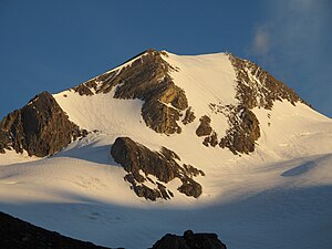
Eastern flank of the Rötspitze (Firntrapez) |
||
| height | 3496 m above sea level A. | |
| location | Tyrol , Austria and South Tyrol Italy | |
| Mountains | Venediger group | |
| Dominance | 5.4 km → Dreiherrnspitze | |
| Notch height | 653 m ↓ Hinteres Umbaltörl | |
| Coordinates | 47 ° 1 '38 " N , 12 ° 12' 16" E | |
|
|
||
| rock | Paragneiss , limestone mica schist | |
| First ascent | August 22, 1854 as part of the military land survey | |
| Normal way | Northeast ridge ( III- ) | |
|
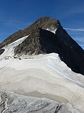
Rötspitze from the southwest |
||
The Rötspitze ( Italian : Pizzo Rosso ), formerly also known as Welitzspitz , is 3496 m above sea level. A. high mountain in the Umbalkamm of the western Venediger group . The state border between the Italian province of South Tyrol and the eastern part of the Austrian state of Tyrol has been running over the summit since 1919 , which here coincides with the border between the Rieserferner-Ahrn Nature Park and the Hohe Tauern National Park . The mountain has a great geographical dominance over the surroundings, as it towers over everything due to its height. In addition to the main summit, which is the highest point of the Umbal ridge , there is also a 3350 meter high north-east summit . The mountain sends out pronounced ridges to the north, south and west, which reach considerable lengths. The first documented climb was the Rötspitze on August 22, 1854 as part of the military land survey by Lieutenant J. Breymann and his assistant. It can be assumed, however, that locals were on the summit beforehand to make preparations for the work of the survey team.
geology
The mountain lies exactly on the border between the lower slate shell and the central gneiss of the so-called Tauern window . This slate shell , together with the upper slate shell, forms the frame of the Tauern window. The orogeny took place here since the Cretaceous by thrusting of continental plates during alpidic folding instead of leading to the formation of gneiss by metamorphosis of the original igneous plutonic stone granite led. The Rötspitze itself consists of the rather less resistant crystalline slate, but has retained its extraordinary height. It primarily contains rocks that were created by the strong pressure of the thrust, the so-called Tauern crystallization . The minerals of the garnet group are well represented, as well as amphibolite , hornblende , eclogite and serpentine .
location
The Rötspitze is the highest point of the Umbalkamm ridge, which runs in a north-south direction . The Prettaukamm branches off in a westerly direction, stretching over a kilometer down to Rotenmannjoch at an altitude of 2,887 m . The Rötspitze is surrounded by glaciers all around . To the northwest lies the Rötkees , in the east the crevice- rich Welitzkees , which extends up to a height of 3480 m to just below the summit, and finally the Schwarzachkees extends southwest . Neighboring mountains along the north ridge are the Untere Rötspitze ( 3290 m ) and the Virgilkopf ( 3036 m ), as well as further along, separated by the Vordere Umbaltörl ( 2928 m ), the 3051 m high Ahrner Kopf and beyond the Hinteren Umbaltörl ( 2843 m ) finally the 3199 m high High Horseshoe . In the course of the south ridge , separated by the Welitzscharte located at an altitude of 3180 m , the Daberspitze ( 3402 m ) and the 3135 m high Tredeberspitze are worth mentioning . To the west, beyond the Rotenmannjoch, lies the 3004 m high Kemetspitze . The next significant settlement is around 6 km straight line west-northwest lies the village Kasern in South Tyrol Ahrntal . On the Austrian side, a good 10 km to the east is the Austrian Hinterbichl in the municipality of Prägraten am Großvenediger in Virgental .
Base and ascent
The path of the first climbers from 1854 led over the southwest flank to the summit. The surveyors set out from St. Valentin ( Prettau ) in the Ahrntal and went through the Röttal , which branches off from the Ahrntal to the southeast near Kasern, up to the Rotenmannjoch and from there over the southwest ridge to the summit. The group spent five days in the bivouac on the summit to await favorable weather conditions for the geodetic triangulation . Today's normal route leads over the northeast ridge of the mountain. Several glacier and rock passages alternate. The northeast ridge can either be reached from South Tyrol from the Lenkjöchlhütte ( 2603 m ) built in 1887 , or from East Tyrol from the Clarahütte via the Philipp-Reuter-Bivouac ( 2677 m ). From the Lenkjöchlhütte the walking time is about three hours, from the Clarahütte about five hours. Climbing points up to difficulty level UIAA III- must be mastered. The previously common, shorter and easier (UIAA I) normal route from the Clarahütte via the Wellizkees and the south-south-east ridge is practically no longer used because the glacier is very cleft and fades away early in summer. Pure alpine combined routes have been leading through the north face since 1974 , in the ice area 50 °, in the rock UIAA V-. Other climbs are possible on the various ridges, in the south face and on the north-east summit. The difficulty here ranges from UIAA II to V.
Literature and map
- Willi End : Alpine Club Leader Venediger Group. Munich 2006, ISBN 3-7633-1242-0 .
- Georg Zlöbl: The three thousand meter mountains of East Tyrol. Verlag Grafik Zloebl, Lienz-Tristach 2005, ISBN 3-200-00428-2 .
- Eduard Richter : Development of the Eastern Alps, III. Tape. Publishing house of the German and Austrian Alpine Club, Berlin 1894.
- Raimund von Klebelsberg : Geology of Tyrol. Borntraeger brothers, Berlin 1935.
- Casa Editrice Tabacco : Carta topografica 1: 25.000, sheet 035, Valle Aurina / Ahrntal, Vedrette di Ries / Rieserferner Group .
- Alpine Club Map 1: 25,000, sheet 36, Venediger Group .
Individual evidence
- ↑ Eberhard Jurgalski : Complete table of summits in the Alps separated by 590 meters of re-ascent , December 12, 2008.
- ↑ Federal Office for Metrology and Surveying Austria: Rötspitze on the Austrian Map online (Austrian map 1: 50,000) .
- ^ Raimund von Klebelsberg: Geologie von Tirol , Berlin 1935, pp. 213, 403, 407
- ^ Eduard Richter: Development of the Eastern Alps , III. Volume, Berlin 1894, p. 154 ff.
- ↑ alpintouren.com: Rötspitze Northeast Ridge / climbing tour
- ^ Georg Zlöbl: The three thousand meter peaks in East Tyrol. P. 128f, see literature
- ↑ Willi End: Alpenvereinsführer Venedigergruppe , Munich 2006, p. 444 ff., Margin no. 1652 ff.


