
Wilhelmshöhe (Radebeul)
The former Berggasthaus Wilhelmshöhe is located in the Wahnsdorf district of the Saxon city of Radebeul , at the address An der Wilhelmshöhe 10. Today the property is used for residential purposes. The slope at the edge above the Oberlößnitz property is located in the conservation area Past vineyard landscape Radebeul and in the conservation area Loessnitz .


.JPG)

description
The slope edge itself is secured by a high terrace wall, which creates a larger guest garden. The main building of the inn and the hall building, both of which are now under monument protection , are located on this area .
The main building on the west side is a two-storey plastered building with a far overhanging gable roof in the Swiss style . The traufständig built to slope edge building is slightly set back from the edge, so that there was still room for berths at the Elbe valley views. At the main house there are some additions and auxiliary buildings that are not listed.
On the east side of the retaining wall is the hall building (monument identification: An der Wilhelmshöhe 9010, location ): It has a basement in the substructure facing the slope. At the top of the terrace is the hall building, which consists of two structures. It is also at right angles to the edge of the slope, is made of half-timbering and has a gently sloping hipped roof . Behind the larger building is a somewhat smaller building of the same design.
history
The main building was built in 1860 as a mountain inn and excursion restaurant on the slope edge above a steep vineyard with a view of the Elbe valley . Carl Friedrich Gommlich is known as a concessionaire in 1866; he was allowed to serve beer, wine and brandy.
The hall-like pavilion construction dates from 1897/1898. The design came from Friedrich Otto Richter from Radeburg , who was also the site manager. During the simplification that took place in 1919, the vented gables on the valley side of the originally historicist building along with the iron roof ornamentation were removed.
Directly to the west and above the restaurant was a brick kiln by the master builder Christian Gottlieb Ziller .
literature
- Volker Helas (arrangement): City of Radebeul . Ed .: State Office for Monument Preservation Saxony, Large District Town Radebeul (= Monument Topography Federal Republic of Germany . Monuments in Saxony ). SAX-Verlag, Beucha 2007, ISBN 978-3-86729-004-3 .
Web links
- Historical photos at the Deutsche Fotothek
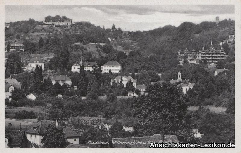
- Postcard from 1930: Wilhelmshöhe u. Bilz sanatorium. (Top left Wilhelmshöhe, top right above the Bilz sanatorium is the Mäuseturm . In the center of the picture is the Hofmannsberg estate , below it on the left Haus Steinbach and on the right Villa Steinbach ; on the right the bell tower of Haus Sorgenfrei . The notch in the top center of the picture represents the valley floor of the Strakens .)
- Photo of the brick kiln above Wilhelmshöhe, this from the rear with extensions (date unknown). ( Memento from December 3, 2013 in the Internet Archive ) In: Manfred Richter: Radebeul on historical postcards; from yesteryear.
Individual evidence
- ^ Large district town of Radebeul (ed.): Directory of the cultural monuments of the town of Radebeul . Radebeul May 24, 2012, p. 6 (Last list of monuments published by the city of Radebeul. The Lower Monument Protection Authority, which has been located in the district of Meißen since 2012, has not yet published a list of monuments for Radebeul.).
- ↑ Gottfried Thiele: Radebeul . In: The archive pictures series . Sutton Verlag, Erfurt 1997, ISBN 3-89702-006-8 , p. 116 .
Coordinates: 51 ° 6 ′ 47.9 " N , 13 ° 40 ′ 27.8" E