Willscheider Berg
| Willscheider Berg | ||
|---|---|---|
|
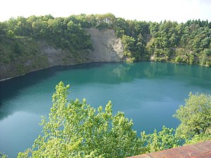
Willscheider mountain lake |
||
| height | 362.9 m above sea level NHN | |
| location | Rhineland-Palatinate , Germany | |
| Mountains | Rheinwesterwälder volcanic ridge , Niederwesterwald | |
| Coordinates | 50 ° 36 '54 " N , 7 ° 19' 54" E | |
|
|
||
| rock | basalt | |
| particularities | Lake in the former basalt quarry | |
The Willscheider Berg (formerly also Wölsberg ) is 362.9 m above sea level. NN high mountain on the edge of the Rheinwesterwälder volcanic ridge . It lies above and west of Vettelschoss in the local community of the same name. The eponymous village of Willscheid is located about one kilometer north of the mountain peak.
The Willscheider Berg was assigned to the municipality of Vettelschoss by drawing lots around 1810 as a former part of the Lorscheid II community. Around 1865, the mining of columnar basalt began on the conical, 370 m high mountain known at the time as "Vellschosser Hüvvel" . The work in the quarry was initially carried out manually by local workers, and in 1884 47 day laborers were counted there. In 1885 the Willscheiderberg residential area had nine residents in one building. The 1888 founded and from 1892 in Linz am Rhein based Basalt AG took over the company in March 1893. To transport the first in eight soles material obtained a 200 m long so-called quickly became Bremsberg used for processing in 1908 a crushing plant . Basalt found its main use in the large dyke construction projects in the Netherlands, as well as in road construction and increasingly in rail construction.
After a slump caused by the war, dismantling in Willscheider Berg, which provided around 100 jobs in 1928, picked up speed again. Its waste dump was also used by the fused basalt plant in Kalenborn, which went into operation in 1924, to deposit its production residues. In 1933 and again towards the end of the Second World War , the quarry was closed and only increasingly started again from 1951. In the meantime, the use of mining methods that made work easier, including so-called drilling and chamber explosions. In addition, the crusher plant on the Meerberg could also be used. As a result, the number of employees fell to 18 by 1967, before excavators were used in the quarry and trucks were used for transport instead of narrow-gauge railways from the following year .
The last 34,200 square meter basalt quarry was officially closed at the end of 1974. In the former mining area he left an inaccessible lake, the so-called Willscheider Bergsee . It is cut about 50 meters deep into the surrounding plateau and is not accessible due to its steep rock walls. The Willscheider Berg is designated as a biotope complex with an area of 4.7 hectares . The company office building on the south-east side of the mountain from 1938 was retained and was given a new purpose in 1983 as a community center. In the 1990s, a wooden tower was built there as a lookout point with a view of the lake, which has since been demolished (as of 2016).
Individual evidence
- ↑ a b Information according to the digital topographic map 1: 5,000 (DTK5)
- ^ Verbandsgemeinde Linz am Rhein (ed.); Adalbert N. Schmitz: Around the Hummelsberg. The Verbandsgemeinde Linz am Rhein , 1984, p. 132.
- ^ Community encyclopedia for the Kingdom of Prussia , Publishing House of the Royal Statistical Bureau (Ed.), 1888, page 45
literature
- Hans Heinrich Mohr: The "Basalt" and Kretzhaus. In: Kretzhaus. Reifstein. Vettelschoß , Bad Tölz 2006, pp. 115–150.
Web links
- ( Page no longer available , search in web archives: biotope complex old basalt mining site near Vettelschoss )

