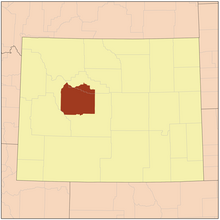
Wind River Indian Reservation

The Wind River Indian Reservation is an Indian reservation of the state in the Midwest Wyoming jointly by the Eastern Shoshone and the Northern Arapaho is inhabited.
It is with 8,995.733 km² of land or 9,147.864 km² with water surface (about 12,000 km² when it was founded) the seventh largest Indian reservation in the United States. It occupies just over a third of Fremont County and more than a fifth of Hot Springs County .
The reserve is located in the Wind River Basin and is surrounded by the Wind River Range , Owl Creek Mountains, and Absaroka Mountains . The reserve borders the Bridger-Teton National Forest to the southwest and the Fitzpatrick Wilderness to the west . There are over 365 lakes and other bodies of water.
The United States Census 2000 records 23,237 residents, of which 6,728 (28.9%) described themselves as at least partially of Indian descent, of which 54% were Arapaho and 30% Shoshone. 22% did not speak English at home .
The largest place is Riverton . The administrative headquarters are in Fort Washakie . There are several Indian casinos that belong to the tribes on the reservation area . These are the only casinos in Wyoming.
history
The Wind River Indian Reservation was established for the Eastern Shoshone in 1868. A military camp, Camp Auger, was established on June 28, 1869 on the site of today's Lander . 1870 it was renamed Camp Brown, moved to its present location in 1871 and finally in 1878 in honor of Shoshonehäuptling Washakie in Fort Washakie renamed. It served the military until 1909 .
A state boarding school and hospital existed east of Fort Washakie. St. Michael's Church in Ethete was built in 1917-20. The settlement of Arapahoe originally served as a distribution station for the rations to the Arapaho and developed into a trading center.
At the end of the 19th century the land was divided among the Indian families and many names were Anglicized . Agriculture was developed through irrigation . A flour mill was built near Fort Washakie.
In 1906 parts of the reservation were released for white settlement and the town of Riverton emerged on this land.
Historical objects
Fort Washakie is home to the historic Fort Washakie Historic District . The area is within the Wind River Indian Reservation on US Route 287 . The Fort Washakie Historic District comprises 36 buildings and was listed on April 16, 1969 by the National Register of Historic Places as a Historic Monument with the number 69000188.
Web links
- Wind River Reservation and Off-Reservation Trust Land, Wyoming United States Census Bureau
Individual evidence
- ^ Wind River Indian Reservation ( English ) In: Geographic Names Information System . United States Geological Survey . Retrieved March 9, 2011.
- ↑ 2000 Census, US Census Bureau
- ^ A b Eastern Shoshone Tribal Culture ( Memento from February 20, 2010 in the Internet Archive )
- ↑ NRIS
- ↑ Fort Washakie Historic Site - Greater Yellowstone ( Memento of March 14, 2014 in the Internet Archive )
- ^ National Register of Historical Places - WYOMING (WY), Fremont County
Coordinates: 43 ° 16'51 " N , 108 ° 48'55" W.
