Wissenbach (Töss, Kollbrunn)
|
Wissenbach Weissenbach |
||
|
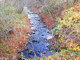
The Wissenbach shortly before the mouth at Schadenwis between Weisslingen (left) and Illnau-Effretikon (formerly Kyburg ) |
||
| Data | ||
| Water code | CH : 649 | |
| location | Switzerland | |
| River system | Rhine | |
| Drain over | Töss → Rhine → North Sea | |
| source | in Oholz near Hagen Buchacher 47 ° 24 '47 " N , 8 ° 46' 8" O |
|
| Source height | 694 m above sea level M. | |
| muzzle | opposite Kollbrunn in the Töss coordinates: 47 ° 27 ′ 19 ″ N , 8 ° 46 ′ 24 ″ E ; CH1903: 700645 / 256911 47 ° 27 '19 " N , 8 ° 46' 24" O |
|
| Mouth height | 489 m above sea level M. | |
| Height difference | 205 m | |
| Bottom slope | 35 ‰ | |
| length | 5.8 km | |
| Catchment area | 10.34 km² | |
| Discharge at the mouth of A Eo : 10.34 km² |
MQ Mq |
200 l / s 19.3 l / (s km²) |
| Left tributaries | Fürbach, Steigbach, Hellbach | |
| Right tributaries | Nothaldenbach, Moosbach, Ländikerbach, Tollenbach | |
| Flowing lakes | Partial pond | |
| Communities | Weisslingen , Illnau-Effretikon | |
The Wissenbach is an approximately six kilometers long left tributary of the Töss in the communities Weisslingen and Illnau-Effretikon in the Swiss canton of Zurich . It flows through the Wisental (also Wiesental) and drains a 10.3 square kilometer section of the Zurich Oberland .
It is not to be confused with the Wissenbach , which flows into the Töss at Bauma .
geography
course
The Wissenbach rises in the municipality of Weisslingen at 694 m above sea level. M. on Nothaldenweg in the corridor Erggel in the forest area Oholz above the farm Hagen Buchacher and below the Nothalden . After a short stream to the northwest, it is overtaken at the edge of the forest at Erggelweg . It crosses under the fields in the Hagenacher and Eichwis area and is now mainly directed towards the northeast, where it also crosses under the Büelacher and takes in the Haselwisbächli from the left.
The stream reaches the hamlet of Theilingen , where it follows the Theilingerstrasse underground . It takes in the Nothaldenbach and the Oberwisbächli , before stepping about 65 meters to the surface in the northern part of the village, between rocks and Tüffi . It crosses under the Cheibenägerten and reappears around 25 meters before the confluence with the Theiligerweiher . The Moosbach and the Ländikerbach flow into the small artificial pond from the right .
The Wissenbach leaves the Theiligerweiher on its northern bank and at the same time crosses the village of Weisslingen. At Steinacher , for example in the center of the village, he is overtaken briefly and picks up the Fürbach from the left , which drains the Brauiweiher . At Schmittenacher it comes to the surface again and now flows northwards, shortly followed by a forest edge. He picks up the Weierbach from the left and passes the ARA on the right bank, where he picks up the water from the Wingertenbächli from the right .
It now reaches the small and narrow Weisental , where it has eaten its way deep into the western valley slope in the upper part between Langacher and Cholgrube . In this section the Mülibächli and Tieracherbächli flow from the right and the Langächerbach , the Steigbach and the Steigholzbächli from the left . It crosses under the Dorfstrasse between Weisslingen and Kollbrunn and takes on the Hellbach from the left at Neu Brünggen , which forms the municipal boundary between Weisslingen and Illnau-Effretikon.
From here it forms the municipal boundary and now runs on the eastern slope of the valley in a north-easterly direction. Shortly afterwards, the Cholgruebbach and the Chotachertobelbach and the Tollenbach flow from the right, before reaching the hamlet of Weisental , which lies on the left bank of the stream. The Wissenbach takes the Wiselwisenbach and the Vorderwaldbach from the right and flows through the valley again towards the north. It left open the Chüeweidbächli , from the right, Gypsy Bach and again left the Rosteltobelbach before he finally opposite Kollbrunn to 489 m above sea level. M. from the left and south flows into the middle course of the Töss.
Catchment area
The 10.3 square kilometer catchment area extends over the municipalities of Illnau-Effretikon and Weisslingen. It consists of 47.3% agricultural area, 44.1% near-natural area and forest, and 8.5% built-up area. The highest point is 735 m above sea level. M. in the corridor Gsang east of Leisibüel , the average altitude is 626 m above sea level. M.
In the west lies the catchment area of the Brandrütibach , the Mülitobelbach and that of the Kempt , which also borders in the southwest, and in the east and southeast that of the Tobelbach . These all also drain into the Töss.
Tributaries
The direct and indirect tributaries downstream
- Haselwisbächli ( left ), 0.3 km
- Nothaldenbach ( right ), 0.8 km
- Schürächerlibach ( right ), 0.5 km
- Holzstiglenbächli ( left ), 0.5 km
- Oberwisbächli ( right ), 0.3 km
- Moosbach ( right ), 1.1 km
- Leisibüelbach ( right ), 0.7 km
- Ländikerbach ( right ), 1.1 km
- Lochbächli ( right ), 0.1 km
- Flueacherbach ( right ), 0.6 km
- Fürbach ( left ), 1.0 km
- Böldbach ( right ), 0.5 km
- Multentöbelibach ( left ), 0.2 km
- Farzelbächli ( left ), 0.5 km
- Böldbach ( right ), 0.5 km
- Weierbach ( left ), 0.3 km
- Wingertenbächli ( right ), 0.3 km
- Mülibächli ( right ), 0.1 km
- Langächerbach ( left ), 0.5 km
- Tieracherbächli ( right ), 0.1 km
- Steigbach (Heubach) ( left ), 2.1
- Breitacherbächli ( right ), 0.1 km
- Tobelholzbächli ( left ), 0.3 km
- Dickibach ( right ), 0.6 km
- Hermannsrütibächli ( left ), 0.2 km
- Hardbächli ( left ), 0.4 km
- Lochweidbächli ( left ), 0.2 miles
- Hüneggbächli ( left ), 0.4 km
- Steigholzbächli ( left ), 0.4 km
- Hellbach ( left ), 2.1 km
- Nägelseebächli ( left ), 0.1 km
- Pfruendholzbach ( right ), 0.1 km
- Nassmattbach ( left ), 0.4 km
- Cholgruebbach ( left ), 0.2 km
- Chotachertobelbach ( left ), 0.8 km
- Bruggwisgraben ( left ), 0.1 km
- Grossachergraben ( left ), 0.3 km
- Brünggbergbächli ( right ), 0.7 km
- Tollenbach ( right ), 1.8 km
- Neuwisenbächli ( right ), 0.1 km
- Seckibächli ( right ), 0.1 km
- Rossenrietbach ( right ), 0.5 km
- Wiselwisenbach ( right ), 0.2 km
- Vorderwaldbach ( right ), 1.8 km
- Chüeweidbächli ( left ), 0.1 km
- Zigeunerbach ( right ), 0.6 km
- Rosteltobelbach ( left ), 0.4 km
Web links
- Course of the Wissenbach on GIS Zurich
- Course of the Wissenbach on the geoserver of the Swiss federal administration
- Wissenbach before Töss
Individual evidence
- ↑ a b individual records of the geographic information system of the canton of Zurich
- ↑ Geoserver of the Swiss Federal Administration ( information )
- ↑ a b c Topographical catchment areas of Swiss waters: sub-catchment areas 2 km². Retrieved September 16, 2017 .
- ↑ Lengths rounded to one decimal place

