Wissenbach (Reuss)
| Wissenbach | ||
|
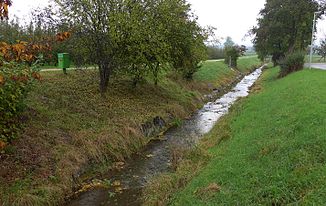
Wissenbach near Merenschwand on the edge of the Reuss plain |
||
| Data | ||
| Water code | CH : 1059 | |
| location | Canton of Aargau , Switzerland | |
| River system | Rhine | |
| Drain over | Reuss → Aare → Rhine → North Sea | |
| confluence | two source brooks under the Chrüzmatte near Horben Castle 47 ° 13 ′ 3 ″ N , 8 ° 19 ′ 22 ″ E |
|
| Source height | 824 m above sea level M. | |
| muzzle | north-east of Merenschwand in the left-hand inner canal of the Reuss plain Coordinates: 47 ° 16 '37 " N , 8 ° 23' 39" E ; CH1903: 672 299 / 236654 47 ° 16 '37 " N , 8 ° 23' 39" O |
|
| Mouth height | 381 m above sea level M. | |
| Height difference | 443 m | |
| Bottom slope | 49 ‰ | |
| length | 9 km | |
| Catchment area | 13.59 km² | |
| Discharge at the mouth of the A Eo : 13.59 km² |
MQ Mq |
270 l / s 19.9 l / (s km²) |
| Communities | Beinwil , Merenschwand | |
The Wissenbach is a 9 km long stream in the canton of Aargau and a left tributary of the Reuss . It drains a strip of land on the eastern slope of the Lindenberg in the communities of Beinwil (Freiamt) and Merenschwand and flows into the inland canal west of the flood protection dam in the Reuss plain.
course
The Wissenbach springs are located on the west side of Horben Castle in the large clearing of the Horbenmatten on the Lindenberg directly on the canton border with Lucerne . The source streams have been straightened as drainage channels and mostly laid in pipes. At Horben Castle, the Wissenbach feeds the small castle pond.
The sources of the Sembach and the Bünz , which, in addition to the catchment area of the Wissenbach, drain the eastern slope of the Lindenberg, are located on the Lindenberg near Schloss Horben .
From the pond, the brook crosses a road embankment and then flows in a north-easterly direction into the Horbentobel in Buechhölzli and through the cattle forest into the Brandtobel west of the village of Beinwil in Freiamt . From the left it takes in the Rinderweidbächli and several short side streams from the Brunnwil field , including the Tobelweidbächlein , passes the Tschöplitobel on the way and reaches the upper, unforested landscape level above the Reuss valley on the northern edge of the village of Beinwil. To the north-east of Beinwil, the brook, which is overturned for almost its entire length, flows out of the Wiehnacht corridor and a brook from Kirchfeld into the Wissenbach, which then flows from the Weihermatt northwards through a flat valley over a moraine step created during the Ice Age to Benzenschwil , a district of the Merenschwand community , flows. At the railway station of Benzenschwil on the railway line Lenzburg - Red Cross of SBB flows from the south by Rüstenschwil and Wallenschwil flowing Bünte Bach in the Bach knowledge.
In a deep valley through the lower lateral moraine, the Wissenbach reaches the upper village of Merenschwand . In this section, the brook has dug up the molasse rocks under the gravel cover in places . To the south of Muri and in the Merenschwander forest with several swamp and wet areas, several brooks arise that flow into the Wissenbach above the village. This feeds two large mill ponds at the edge of the forest and passes the old mill and sawmill, the district of Burg and the lower mill of Merenschwand, before flowing east of the church into a deep canal that was created during the rehabilitation of the Reuss valley level. The canal has a curved course past the nature reserves Schoregrindel, Siebeneichen and Wasserfallen and several ponds and ends south of the Reuss bridge from Ottenbach in the Reuss Canal. In the Reuss level the Güllerigraben drainage canal flows into the Wissenbach from the left .
On the Wissenbach, below Merenschwand, there is a measuring station that has been in operation since 1980.
photos
Individual evidence
- ↑ Individual records in the geographic information system of the canton of Aargau
- ↑ Geoserver of the Swiss Federal Administration ( information )
- ↑ a b Topographical catchment areas of Swiss waters: sub-catchment areas 2 km². Retrieved June 23, 2019 .
- ↑ Canals in the Reuss Plain
- ^ Heinrich Jäckli (inter alia): Canton Aargau. Rehabilitation of the Reuss valley level, a partnership project. Aarau 1982.
- ↑ Station sheet


