Voronezh (river)
|
Voronezh Воронеж |
||
|
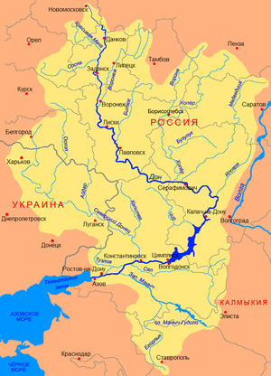
Course of the Voronezh (Воронеж) with source rivers in the catchment area of the Don |
||
| Data | ||
| Water code | RU : 05010100512107000002368 | |
| location | Oblast Tambov , Lipetsk , Voronezh ( Russia ) | |
| River system | Don | |
| Drain over | Don → Black Sea | |
| confluence | of Lesnoi Voronezh and Polnoi Voronezh at Michurinsk 52 ° 50 '5 " N , 40 ° 24' 34" O |
|
| muzzle | near Schilowo in the Don Coordinates: 51 ° 31 '36 " N , 39 ° 5' 12" E 51 ° 31 '36 " N , 39 ° 5' 12" E
|
|
| length | 342 km | |
| Catchment area | 21,600 km² | |
| Runoff at the Voronezh gauge |
MQ |
70.8 m³ / s |
| Left tributaries | Matyra , Usman | |
| Right tributaries | Stanovaya Ryasa | |
| Reservoirs flowed through | Voronezh reservoir | |
| Big cities | Lipetsk , Voronezh | |
| Navigable | Lower course | |
|
River bank |
||
|
Lesnoi Voronezh Лесной Воронеж |
||
| Water code | RU : 05010100512107000002450 | |
| location | Ryazan Oblast , Oblast Tambov | |
| River system | Don | |
| Drain over | Voronezh → Don → Black Sea | |
| source | in the south of Ryazan Oblast 53 ° 41 ′ 44 ″ N , 40 ° 38 ′ 0 ″ E |
|
| Union | with Polnoi Voronezh to Voronezh 52 ° 50 ′ 5 ″ N , 40 ° 24 ′ 34 ″ E
|
|
| length | 164 km | |
| Catchment area | 2140 km² | |
| Big cities | Michurinsk | |
| Small towns | Starojuryevo | |
|
Polnoi Voronezh Польной Воронеж |
||
| Water code | RU : 05010100512107000002375 | |
| location | Ryazan Oblast , Oblast Tambov | |
| River system | Don | |
| Drain over | Voronezh → Don → Black Sea | |
| source | in the south of Ryazan Oblast 53 ° 30 ′ 37 ″ N , 41 ° 2 ′ 55 ″ E |
|
| Union | with Lesnoi Voronezh to Voronezh 52 ° 50 ′ 5 ″ N , 40 ° 24 ′ 34 ″ E
|
|
| length | 178 km | |
| Catchment area | 2170 km² | |
| Small towns | Dmitrievka | |
The Voronezh ( Russian Воронеж ) is a 342 km long left tributary of the Don in western Russia in the Oka-Don plain . It is formed near Michurinsk by the two source rivers Lesnoi Voronezh ("Forest-Voronezh", 164 km, from the right) and Polnoi Voronezh ("Field Voronezh", 178 km, from the left), both in the border area of the Oblasts Ryazan and Tambov arise from.
The old name of the river was Velikoi Voronoi , which means something like "Great Black River". The current name is derived from this.
Its catchment area covers 21,600 km², the mean flow rate (MQ) in Voronezh is 70.8 m³ / s. The river freezes over in December and remains frozen until the end of March. Only the lower reaches are navigable.
The middle reaches of the Voronezh runs through the Lipetsk Oblast , while it crosses the city of Lipetsk . A dam wall was built behind the city of Voronezh between 1971 and 1972. The resulting Voronezh reservoir has an area of about 70 km² and stretches from the southern city limits of Voronezh about 30 km to the northern city limits. A little below the dam, the Voronezh flows into the Don at Schilowo .
Web links
Individual evidence
- ↑ a b c d e Article Voronezh in the Great Soviet Encyclopedia (BSE) , 3rd edition 1969–1978 (Russian)
- ↑ a b Voronezh in the State Water Register of the Russian Federation (Russian)
- ↑ a b Lesnoi Voronezh in the State Water Register of the Russian Federation (Russian)
- ↑ a b Polnoi Voronezh in the State Water Register of the Russian Federation (Russian)


