
Worringer Platz
| Worringer Platz | |
|---|---|
|
|
|
.jpg) Worringer Platz from the west |
|
| Basic data | |
| place | Dusseldorf |
| District | City center |
| Created | 1906 |
| Newly designed | 1962-1964, 2002-2007 |
| Confluent streets | Kölner Strasse , Karlstrasse, Worringer Strasse, Erkrather Strasse, Klosterstrasse |
| use | |
| User groups | Pedestrian traffic , bicycle traffic , car traffic , public transport |
| Space design | Tram stop |
| Technical specifications | |
| Square area | approx. 4500 m² (excluding street areas) |
The Worringer Platz is a traffic junction in Dusseldorf - City Center .
Location and description
The busy square is located in the eastern area of Düsseldorf's Stadtmitte district . Roads run towards him from all directions. The Kölner Straße , which leads to it from the northwest and southeast, and the Worringer Straße, which meets it from the north and south, are divided into sections by it. Karlstrasse comes from the southwest, Klosterstrasse from the west and Erkrather Strasse from the east.
The square describes the basic shape of a triangle . Its edges form multi-storey, closed development of residential and commercial buildings. Separated by multi-lane streets at its edges, the urban space in the center has a pedestrian, triangular square that accommodates the Worringer Platz tram stop and is interrupted in the north-south direction by tracks on tram lines 704, 708 and 709.
history
The square was named on March 1, 1906. It commemorates the Battle of Worringen , as a result of which Düsseldorf was elevated to the status of a city on August 14, 1288. As early as 1893, the Ringstrasse , which once ran across today's square, was renamed Worringer Strasse in memory of this historical context . Before roads were built, tracks of the Cologne-Mindener Eisenbahn-Gesellschaft ran over the area.
Favored by the growth of Düsseldorf in the course of high industrialization , a four-story residential development developed on Worringer Platz in the early days , which housed numerous shops on the ground floor, as well as a large number of restaurants, which were particularly frequented by industrial workers from Flingern and Oberbilk . In addition to the Oberbilker Markt , the square has always been a meeting place for the organized labor movement . In 1891, the centrality increased with the opening of the Düsseldorf central train station located around 500 meters to the south .
In the 1920s, the square was given an expressionistically designed pavilion with a tower, from the top of which the figure of a Kiepenkerl looked down, a sculpture by the sculptor Emil Jungblut . In 1927/1928, the cinema architect Oskar Rosendahl built the “Capitol” cinema at Worringer Platz 4. It existed until the mid-1970s. In 1970 the musical Hair was performed there.
During the Nazi era , the square was renamed after Horst Wessel . On May 14, 1940, Willi Pesch , a legendary goalkeeper of Fortuna Düsseldorf , had a fatal accident there in a tragic tram accident . During the Second World War, the historical buildings on the square were reduced to rubble and ashes by air raids .
.jpg)
In the post-war period , the square was renamed and the old lines of the heavily destroyed buildings were quickly rebuilt. Because of the sharp increase in motor traffic , the city of Düsseldorf built an underpass equipped with escalators for pedestrians in 1962 , which, however, subsequently developed into a fearful space and was therefore closed in 1994. Located in the vicinity of Düsseldorf Central Station , the square has acquired a dirty image in recent decades and is considered a hotspot for the drug scene . In addition to amusement arcades, kebab shops and betting offices, cultural projects, galleries and artists, such as the WP8 artists' association, have also settled in vacant rooms on the square and in the immediate vicinity since the 1990s .
Under Mayor Joachim Erwin , the city administration and Rheinbahn tried to counteract urban development and design deficits in a plan for urban redevelopment from 2002 by redesigning the square and its tram stop, which was completed in 2007. The "green island" was created based on designs by Annette Hartung (lighting design, Cologne), Jürgen LIT Fischer (art: "Green beam", light installation, 36 m high pylon) and Alexander Nix and Christiane Voigt (landscape planning, Contur 2 planning group, Essen) a new city square paved with green concrete blocks with an integrated green LED grid of 170 individual lights as well as “city sofas”, benches , made of greenish glass blocks , which should give the square around 100 meters of visible edges and shield it from visual and acoustic traffic . Part of the project since 2003 has been the Librarium or Glasshouse exhibition pavilion of the artist group A & O (Anne Mommertz and Oliver Gather), which is curated under the title Gasthof Worringer Platz .
gallery
- Shops

Long-established business for party items, medals, etc.
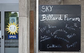
Game Room

Kebab restaurant

Martial arts fitness bar
.jpg)
.jpg)
.jpg)
.jpg)
- Art and street art

Artists Association WP8
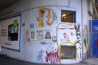
graffiti
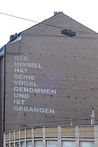
"Heaven has taken its birds and gone"

“Each seat can take three benches with alcoholics. - But not every resident. "
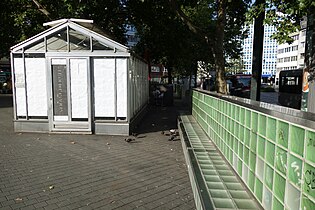
Glass house and "city sofa"
_(1).jpg)
.jpg)
.jpg)
.jpg)
.jpg)
Web links
- Worringer Platz , website in the portal stadtgeschichten-duesseldorf.de
- A place by chance , website in the portal dmitte.de
Individual evidence
- ^ Fritz Hollstein: Persecution and Resistance in Düsseldorf 1933-1945. A city guide . WI-Verlag, Düsseldorf 1989, ISBN 3-98059-630-3 , p. 55
- ↑ Petra Gutkin: Imagine you are a child - and it's war. My father tells. A biography about Peter Wolf . Books on Demand, Norderstedt 2011, ISBN 978-3-84237-682-3 , p. 12 ( Google Books )
- ↑ Kira Bayer: "Bloody syringes everywhere". Resident hell: situation at Düsseldorf's drug square escalates . Article from June 18, 2020 in the express.de portal , accessed on August 6, 2020.
- ↑ Worringer Platz , website in the portal thedorf.de , accessed on August 6, 2020.
- ↑ A green island day and night. Worringer Platz in Düsseldorf . In: Garten + Landschaft , Volume 117 (Issues 1–6, 2007), p. 48
- ↑ Worringer Platz , website in the contur2.de portal , accessed on August 6, 2020
- ↑ Worringer Platz Düsseldorf . In: Torsten Wiemken, David R. Froessler (editing), Innovationsagentur Stadtumbau NRW (ed.): Light in urban redevelopment. The use of light in strategies and projects for urban redevelopment. Goals, functions and instruments . Good Practice Reader, No. 6, April 2011, pp. 60 f. ( PDF ; 1.6 MB)
- ^ Worringer Platz, Düsseldorf , website in the portal mannwerk.com , accessed on August 6, 2020
- ↑ Nicolas Beucker: Surfaces as inscription potential in urban space . In: Anne-Kathrin Auel u. a .: Surface . IKUD series for art and design studies. Volume 4/2011, Lit Verlag, Berlin 2012, p. 29
- ↑ Gasthof Worringer Platz , accessed on August 6, 2020.
Coordinates: 51 ° 13 ′ 25.8 " N , 6 ° 47 ′ 44.8" E