Wuppertal Valley
| Wuppertal Valley | |||
|---|---|---|---|
| Relief of the Wuppertal Valley | |||
| Systematics according to | Handbook of the natural spatial structure of Germany | ||
| Greater region 1st order | Low mountain range threshold | ||
| Greater region 2nd order | Rhenish Slate Mountains | ||
| Main unit group | 33 → Süderbergland |
||
| About main unit | 337 → Bergisch-Sauerland lowlands |
||
| 4th order region (main unit) |
337 1 → Niederbergisch-Märkisches hill country |
||
| Natural space |
337 1 .3 → Wuppertal Valley |
||
| Geographical location | |||
| Coordinates | 51 ° 15 '32.4 " N , 7 ° 10' 22.8" E | ||
|
|||
| local community | Wuppertal , Schwelm | ||
| state | North Rhine-Westphalia | ||
| Country | Germany | ||
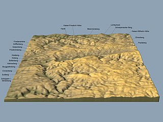
The Wuppertal Senke is a natural spatial unit with the order number 337 1 .3 in the urban area of the Bergisch city of Wuppertal and the Westphalian town of Schwelm . It belongs to the over-main unit Bergisch-Sauerländisches Unterland , order number 337 in the structure Niederbergisch-Märkisches Hügelland (order number 337 1 ).
The depression consists of heavily folded, karstified limestone from the Central Devon , which has been eroded and karstified by high levels of precipitation and which is extensively leveled at an average altitude of 200 m. The valley is divided by the Wupper , the Schwelme and their tributaries. To the north and south, steep slopes rise to high ridges and plateaus, which consist of greywacke , sandstone and slate . Island-like elevations such as the Linderhauser ridge , the Hardtschiefer ridge or the Nützenberg cross bar structure the Wuppertal limestone basin. They were created by special folds and clump-like elevations.
structure
- 337 1 .3 Wuppertal Valley
- 337 1 .30 Linderhauser Senke
- 337 1 .31 Schwelmer mass limestone valley
- 337 1 .32 Linderhauser back
- 337 1 .33 Limestone basin in Barmer
- 337 1 .34 Hardt slate back
- 337 1 .35 Elberfeld limestone sink
- 337 1 .36 Nützenberg crossbar
- 337 1 .37 Sonnborn limestone area
- 337 1 .38 Vohwinkel depression

