Hardtberg (Wuppertal)
| Hardtberg | ||
|---|---|---|
|
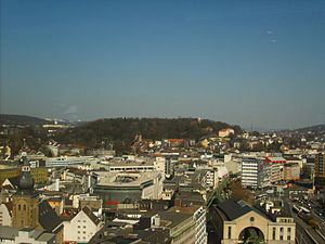
The Hardtberg from the west |
||
| height | 238.1 m above sea level NHN | |
| location | Wuppertal | |
| Mountains | Rhenish Slate Mountains | |
| Coordinates | 51 ° 15 '53 " N , 7 ° 10' 6" E | |
|
|
||
| particularities | - Park - Elisenturm ( AT ) - Bismarck tower ( AT ) - Hardthöhlen |
|
|
The surveys in Wuppertal |
||
|
Clearly visible rock layers in the Hardt gallery |
||
The Hardtberg , often just called Hardt , is a partially wooded 238.1 m above sea level. NHN high elevation in Wuppertal's inner city area, on the border between the districts of Elberfeld and Barmen . Wuppertal's most important park is located on it, the Hardt or the Hardt facilities , as well as the Elisenturm and Bismarck tower .
Topography and natural division
The Hardtberg reaches a height of 238 meters and is therefore a good hundred meters above the bottom of the Wupper . The ridge has a length of approx. Two kilometers in a west-east direction and a width of up to 900 meters.
In the Hardtberg there are Wuppertal's most important caves, the Hardthöhlen . The protected cave system is not open to the public.
In order to build a nuclear-safe energy supply in the form of a cavern power station, a tunnel was driven into the mountain on the Hardtufer in the 1960s, during the “Cold War”. During the drive, not only the slate typical of the Honsel layers, but also limestone was driven through. It has long been known that a small cave - the deep hard cave - was cut. However, the interior of the mountain did not provide enough water to operate such a power plant. So the project was canceled and the tunnel that had been driven into was tightly closed. Since 2015 this facility has also been officially supervised by the Kluterthöhle eV working group.
The Hardtberg forms the natural spatial unit of the Hardt slate ridge (order number 337 1 .34) within the Wuppertal valley . There it sharply separates the Elberfeld limestone basin from the Barmer limestone basin . Geologically, it consists of Lenne slate in which limestone banks are embedded.
Development
While the rather steep south-facing slopes in the late 19th century were often built on with villas or houses from the Wilhelminian era in the lower part , there are some allotment gardens on the northern edge. The slightly higher peripheral areas are covered with deciduous forest. On the ridge itself there are tree-lined meadows.
In addition to the Hardt park, the building ensemble of the church college and the former prison school are located on the top of the elevation . In the west, within the park, there is an open-air stage on the slope ( Waldbühne Hardt ). There used to be a quarry here.
Etymology and history
The word Hardt is as wooded slopes , forest slope and is often to be found in any derivative in the German language.
The first secured documentary mention of the mountain forest took place in a document from 1593 as a wooded hardt . According to a copy of an older border description (14th / 15th century), the outer border of the Free County of Volmarstein ran over the Hardtberg in the Middle Ages . In the late Middle Ages and early modern times , following this old border, the Elberfeld line of the Bergische Landwehr ran across the mountain in a north-south direction and now separated the Bergisch offices of Elberfeld and Beyenburg .
The Elberfeld gallows stood on the hardt . Therefore, the south-western mountainside was still called Galgenberg at the end of the 19th century .
From 1812 to 1837 the only surviving windmill in today's Wuppertal urban area was operated on the Hardtberg . The Elisenturm was later built on the foundation of the building .
The holy mountain
Popularly at the beginning of the 19th century, this hill was also called "Holy Mountain", as the Barmer Mission, founded in 1818, had its home here. This name is still proclaimed today mainly in circles of the church university, the name is not very common among the population.
Individual evidence
- ↑ GEOviewer NRW in the GEOPortal NRW, scale 1: 2,000
- ↑ Working group Kluterthöhle eV The deep hard cave in the Hardt tunnel
- ↑ Handbook of the natural spatial structure of Germany: Sheet 108/109: Düsseldorf / Erkelenz (Karlheinz Paffen, Adolf Schüttler, Heinrich Müller-Miny) 1963; 55 p. And digital version of the corresponding map (PDF; 7.4 MB)
- ↑ Julius Leithäuser : field names from Elberfeld and the surrounding area, which testify to the former abundance of forests and game. In: Journal of the Bergisches Geschichtsverein , Volume 43, 1910, Chapter VIII.
- ↑ Otto Schell : To the Gesch. the Elberfelder Hardt. Monthly VII, pp. 26-36, 45-58.
- ^ Wuppertal nicknames: Lustwandeln auf dem Heiligen Berg Westdeutsche Zeitung (online) from January 29, 2010
Web links
- Photo gallery of the cavern tunnel , on Wuppertaler-Unterwelten.de


