Zeller Bach (Irrsee)
|
Zeller Bach Zellerbach |
||
|
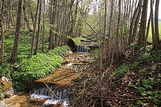
Middle course of the Zeller Bach |
||
| Data | ||
| Water code | AT : HZB: 2-122-152-001-014 | |
| location | Salzkammergut , Upper Austria | |
| River system | Danube | |
| Drain over | Irrsee → Zellerache → Mondsee → Seeache → Attersee → Ager → Traun → Danube → Black Sea | |
| River basin district | Danube below Jochenstein (DUJ) | |
| Beginning | at Lackenberg 47 ° 53 '28 " N , 13 ° 20' 17" E |
|
| Source height | 754 m above sea level A. | |
| muzzle | in Zell am Moos Coordinates: 47 ° 54 ′ 7 ″ N , 13 ° 18 ′ 42 ″ E 47 ° 54 ′ 7 ″ N , 13 ° 18 ′ 42 ″ E |
|
| Mouth height | 553 m above sea level A. | |
| Height difference | 201 m | |
| Bottom slope | 75 ‰ | |
| length | 2.7 km | |
| Catchment area | 2.398 km² | |
| Communities | Zell am Moos , Tiefgraben | |
| ⊙ | ||
The Zeller Bach (also spelled Zellerbach ) is a small brook on the Zeller or Irrsee in Mondseeland , part of the Salzkammergut in the Hausruckviertel of Upper Austria .
The brook is not to be confused with the Zeller Ache , the outflow of the lake.
Run and landscape
The stream rises about 1½ kilometers east of the southern end of the lake on the western slope of the Lackenberg ( 925 m above sea level ), below Sulzberg at about 750 m above sea level. A. It flows northwest and between Zellgraben and Lindau forms most of its course the municipal boundary from Tiefgraben to Zell am Moos . It passes the Tiefgrabener houses Am Zellerbach , here comes the ditch at Thalbauer from the left .
From Mondsee Straße (B154) it is then the village stream of Zell am Moos . At the church square the trenches from Niederbrandstatt run towards him from the right . After a good 2½ kilometers it flows into the Irrsee ( 553 m above sea level ) at Zell-am-Mooser Seebad .
Geology and hydrography
The stream comes from a marginal moraine of the Dachstein glacier from the Würm Ice Age (approx. 100,000-10,000 years before today), the last glacial period that left a wall west of the Irrsee into the Haslau . Young Vöckla was squeezed in behind it . The north-westerly course is unusual here: the Mondsee- Irrsee area represents the post-glacial retreat of the Dachstein glacier tongue , and therefore drains into the Alps (“upside down”, the water only flows back towards the edge of the Alps from the Attersee). Most of the small feeders also follow this. Zellerbach, north of the Ramsaubach or the Iltisbach opposite the Kolomannsberg go in the opposite direction. It is expected to run to training in late-würmzeitlichen glacier retreat - advance act south near Guggenberg a rock barrier is transverse in the valley and then to the lake with gas passing ausstreifend, followed by the stream.
Web links
Individual evidence
- ↑ a b c d e f DORIS information , topic water & geology , information on detailed catchment areas and reporting water network , doris.ooe.gv.at
- ↑ a b Stationed up to km 2,671; the brook is hydrographically stationed up to the lake's axis, where it flows out at km –0.3715, total hydrographic length 3.0425 kilometers.
- ↑ Corresponding to the Vöckla and the Irrsdorfer Bach north of the lake, the former flows on the edge of the Alps to the Ager, the latter to Mattig and Inn.
- ↑ Gustav Görzinger: 1959 report on recordings on the Straßwalchen sheet (64) . In: Negotiations of the Federal Geological Institute 1960, Quaternary section : Zellerseer branch of the Traungletscher , p. A 38 ( full article p. A 36–38, pdf , opac.geologie.ac.at).
- ↑ cf. Eberhard Fugger: The Upper Austrian Pre-Alps between Irrsee and Traunsee . In: Yearbook dkk geol. Reichsanstalt. 1903, Volume 63, Issue 2, Chapter Der Irrsee , especially p. 298 (full article p. 295–350, with panel XIV., PDF, geologie.ac.at , there p. 4).
