
Puerto Vallarta
Puerto Vallarta | |
|---|---|
 | |
| Nickname: P.V. | |
 Location within the state of Jalisco | |
 Jalisco's location within Mexico | |
| Country | |
| State | Jalisco |
| Municipality | Puerto Vallarta |
| Founded | 1851 |
| Government | |
| • Mayor | Lic. Francisco Javier Bravo Carbajal |
| Area | |
| • Municipality | 1,300.7 km2 (502.19 sq mi) |
| Elevation | 7 m (23 ft) |
| Population (2005) | |
| • Total | 177,830 |
| • Municipality | 220,368 |
| • Demonym | Vallartense |
| Time zone | UTC-6 (CST) |
| Postal code | 48300 |
| Area code | 322 |
| Website | www.puertovallarta.gob.mx |
Puerto Vallarta is a Mexican resort city situated on the Pacific Ocean's Bahía de Banderas. The 2005 census reported Puerto Vallarta's population as 177,830 making it the fifth-largest city in the Mexican state of Jalisco. The City of Puerto Vallarta is the government seat of the Municipality of Puerto Vallarta which comprises the city as well as population centers outside of the city extending from Boca de Tomatlán to the Nayarit border (the Ameca River). The municipality's population in the 2005 census was 220,368.[1]
The city is located at 20°40′N 105°16′W / 20.667°N 105.267°W. The municipality has an area of 502.19 square miles (1,300.67 km²). To the North it borders the SW part of the state of Nayarit. To the East it borders the municipality of Mascota and San Sebastián, and to the South it borders the municipalities of Talpa de Allende and Cabo Corriente.[2]
Puerto Vallarta is named after Ignacio Vallarta, a former governor of the state of Jalisco. "Puerto Vallarta" is often shortened to "Vallarta." and English (language) speakers call the city P.V. for short. In internet shorthand the city is often referred to as PVR, after the code for its international airport. English speakers sometimes misspell or mispronounce the city's name as "Porto Vallarta".
Climate
Puerto Vallarta enjoys a typical tropical climate, with near constant temperature and humidity year round and with a pronounced wet and dry seasonal variation.
The average daily high temperature is 86 °F (30 °C); average daily low temperature is 70 °F (21 °C); average daily humidity is 75%. The rainy season extends from mid June through Mid October, with most of the rain falling between July and September. August is the city's wettest month with an average of 14 days with significant precipitation. Even during the rainy season precipitation tends to be concentrated in large rainstorms with insignificant precipitation on most days. Occasional tropical storms will bring thunderstorms to the city in November, though the month is typically dry. February, March and April are the months with the least cloud cover.[3]
Prevailing winds are from the SW, and most weather systems approaching Puerto Vallarta are consequently weakened as they pass over Cabo Corriente. Thus even during the rainy season Puerto Vallarta's weather tends to be mild compared to other areas along the Mexican Pacific coast.
Hurricanes seldom strike Puerto Vallarta. In 2002 Hurricane Kenna, a category 5 hurricane, made landfall about Template:Mi to km NW of Puerto Vallarta, and the city suffered some damage from the resulting storm surge. In 1971 Hurricane Lily, a category 1 hurricane, caused serious flooding on the Isla Cuale, prompting the city to relocate all of its residents to the new Colonia Pa'lo Seco.
Geography, Geology and Ecology
Geographical characteristics
Puerto Vallarta sits on a narrow coastal plain at the foot of the Sierras Cuale and San Sebastián, parts of the Sierra Madre Occidental. The plain widens to the North, reaching its widest point along the Ameca river. Three rivers flow from the Sierra through the area, from South to North, the Cuale, the Pitillal, and the Ameca. A number of arroyos also run from the Sierra to the coastal plain. Many of the valleys of these rivers and arroyos are inhabited. Also development has to some extent spread up the hillsides from the coastal plain.
The city proper comprises four main areas: the hotel zone along the shore to the North, Olas Altas - Col Zapata to the South of the Cuale river (named Zona Romantica recently in some tourist brochures), the Centro along the shore in between these two areas, and a number of residential areas to the East of the hotel zone. The oldest section of town is the area of Col. Centro near the church of Our Lade of Guadalupe, especially Hidalgo street.
Seismic history
Puerto Vallarta, like much of Mexico, is prone to earthquakes, though Puerto Vallarta tends to experience only peripheral effects of earthquakes centered further south. In 1995 an Earthquake located off the Colima coast shook the crown from the top of the cathedral. More recently regional earthquakes have cause minor damage in town, causing pools to leak, cracking plaster, etc.
Economy
Nearly 50% of the workforce is employed in tourist related industries: hotels, restaurants, personal services, and transportation. The municipality does however continue to have strong agricultural, industrial and commercial sectors.
Industries
Agriculture is especially important in the Ameca valley to the NE of the city center. Principal crops there include flour corn, sweet corn, dry beans, fresh chile, watermelon and tobacco. Fruit growing operations are more dispersed, with banana farms in the Ameca valley, Mango orchards in the low hills, and avocado farms on some of the higher ground above the city.
There are also significant livestock operations located in the Ameca valley, and of course fishing in the Bay of Banderas is also a significant industry.
Industrial production includes food and beverage production (e.g. the Modelo plant near the airport), furniture production, and construction supplies. Thirty years of consistent development have given Puerto Vallarta a very strong construction sector which employs nearly 10% of the Puerto Vallarta workforce.
The commercial sector comprises nearly 17% of the workforce, including shipping, trucking, wholesale and retail operations (though the retail sector is probably understated because of the large underground economy in the sector).[4]
Shipping traffic consists of cruise ships, which arrive almost daily, and occasional visits by U.S. Navy frigates. The Mexican Navy maintains a base at the port, as well as a former naval hospital in the city center, which is now a Naval Museum. Puerto Vallarta is not however very active as a commercial port. Most goods arrive in Puerto Vallarta by truck along the Compostela highway from Guadalajara.
Tourism trends
Tourism makes up roughly 50% of all economic activity in Puerto Vallarta according to puertovallarta.net. The high season for international tourism in Puerto Vallarta extends from late November through March (or later depending on the timing of the College Spring Break period in the USA. The city is especially popular with US residents from the West Coast because of the number of convenient flights that exist between Puerto Vallarta and Los Angeles, San Francisco and Seattle. The air routes between Puerto Vallarta and Los Angeles and Puerto Vallarta and San Francisco are by far the most heavily traveled of all air routes into the city.
Vallarta is also a popular destination for Mexican tourists: a popular weekend destination for residents of Guadalajara (tapatíos), and a popular national destination for vacations such as Semana Santa (the week preceding Easter) and Christmas. Also in recent years Acapulco has experienced a rise in drug related violence[5] and Puerto Vallarta has absorbed some of the Mexico City resort vacation business (Acapulco is a very common destination for tourists from Mexico City).
Puerto Vallarta has become a popular retirement destination for US and Canadian retirees. This trend has spawned a condominium development boom in the Conchas Chinas Hills on the South end of the city.
Also over the past decade, Puerto Vallarta has become a popular gay vacation destination, and consequently the Olas Altas area now boasts about a dozen clubs, several hotels, and numerous specialty shops catering to a gay clientele.
Rapid growth in tourist volume in Puerto Vallarta has given rise to rapid growth in hotel and rental apartment construction. This growth has spilled over from the city limits into Nuevo Vallarta in the neighboring state of Nayarit.
Population and growth rate for the Municipality of Puerto Vallarta
| 1950 | 1960 | 1970 | 1980 | 1990 | 2000 | |
|---|---|---|---|---|---|---|
| Total | 10,801 | 15,462 | 35,911 | 57,028 | 111,457 | 184,728 |
| Annual growth prior ten years | --- | 3.6% | 9.1% | 4.6% | 7.1% | 5.2% |
source: Cuaderno Estadistico Municipal[6]
Growth Related Problems
Water Pollution
Visibility in the water off of Puerto Vallarta is poor because of the number of rivers and streams that flow into the bay and because of the populated areas drained by these streams. Fertilizer and untreated waste are the principal causes of algae and plankton blooms, so that even during the dry season water visibility is very low. The Mariettas Islands off of Punta Mita enjoy better visibility because of their distance from the main river drainages.[citation needed]
Recently jellyfish blooms in the fall have become an increasing problem, making many of the area beaches unsuitable for swimming. It's likely that the blooms are the result of increased algae levels and decreases in predator populations due to the ever declining quality of the water in the bay. While the city government has done a lot to improve sewage treatment, it has done little to enforce its usage and, and the worsening jellyfish bloom is probably a consequence of the resulting plankton blooms.[7]
Recently (2006) beaches in Jalisco were ranked as the worst in the country in a government study. The beaches at Boca de Tomatlan and at the mouth of the Cuale in the heart of Puerto Vallarta tested repeatedly at rates 3 to 4 times internationally accepted standards for human fecal bacteria.[8] Even the beaches at seemingly idyllic Yelapa and Mismaloya tested at the same high levels on several occasions. During the rainy months of June and July the situation becomes worse. For example in July 2007 Los Muertos beach tested at 12 times the limit that the US EPA considers safe for swimming.[9]
Poverty
Poverty remains a problem in Puerto Vallarta, fueled by the constant influx of persons seeking employment. Many areas of the city are still poorly served by roads and sewers. For example Colonia Ramblases is served by roads in generally poor condition only 10% of which are paved, and Ramblases has been a populated neighborhood since 1940s.[10]
The Municipality of Puerto Vallarta comprises about 45,000 regular dwellings. Of those 10% do not have a potable water supply (carrying their water from a public tap), 8% do not have connections to a sewer system or septic system (using instead crude septic pits or dumping sewage directly in to waterways), 4% do not have electricity.[11]. One reason for this is the difficulty the city has enforcing building regulations.
While compared to Mexico as a whole employment levels are quite high, many of the jobs available in Puerto Vallarta are classed as inferior by the Secretariat for Social Development, and even jobs that are generally well paying tend to be seasonally so. E.g. waiters depend heavily on tips to supplement incomes that can be as low as 47 pesos a day - the applicable minimum wage in Jalisco.[12]
There have recently (2005 to 2007) been improvements like the new IMSS facilities in Col. Versalles, improvements to several recreation facilities, improved communal beach access policies, etc. Still efforts seem to aim more at quick and visible infrastructure improvements than at solving the more pressing and perduring problem of insufficient infrastructure for basic service.[13]
One positive result of recent growth has been that in relative terms a smaller percentage of the population lives in older and poorly served neighborhoods. A growing number of residents live in housing projects and low income housing developments which provided with at least adequate basic services. So perhaps having stemmed growth of the problem with the new developments, the City will eventually be able to devote its resources to improving existing neighborhoods.[14]
History
Puerto Vallarta's proximity to the Bay of Banderas, the agricultural valley of the Ameca River, and the important mining centers in the Sierra have given the town a more interesting past than most Mexican tourist destinations. Puerto Vallarta was a thriving Mexican village long before it became an international tourist destination.[15]
Pre-Hispanic times to the 19th century
Few details are known about the history of the area prior to the 19th century. There is archaeological evidence of continuous human habitation from 580 B.C., and there is archeological evidence (from sites near Ixtapa and in Col. Lázaro Cardenas)[16] that the area belonged to the Aztatlán culture which dominated Jalisco, Nayarit and Michoacán from aprox. 900-1200 A.D. Unfortunately the limited evidence and relative lack of interest in occidental Mexican archeology have meant that we still know very little about pre-historic life in the area.[17]
Spanish missionary and conquistador documents chronicle skirmishes between the Spanish colonizers and the local peoples. In 1524, for example, a large battle between Hernán Cortés and an army of 10,000 to 20,000 Indians resulted in Cortés taking control of much of the Ameca valley. The valley was then named Banderas (flags) after the colorful standards carried by the natives.
Also the area appears on maps and in sailing logs as a bay of refuge for the Manila Galleon trade as well as for other coastal seafarers. As such it figures in some accounts of pirate operations and smuggling and pirate contravention efforts by the viceregal government. During the 17th and 18th centuries the Banderas Valley and its beaches along the Bay of Banderas served as supply points for ships seeking refuge in the bay. The area also served as a point where smuggled goods could be sent on to the Sierra towns near Mascota, evading the customs operations at San Blas, Nayarit.
El Carrizal and Las Peñas - 19th century
During the nineteenth century the history of Puerto Vallarta, then called El Carrizal or Las Peñas, was linked to the history of the sierra towns of San Sebastian, Talpa de Allende and Mascota. While today these towns are considered quaint tourist destinations, during much of the 18th century, Mascota was Jalisco's second largest town, after Guadalajara. Mascota and its neighboring towns located in the high plateaus of the Sierra, developed as agricultural towns to support the growing mining operations in the Sierra. During the 18th century, as Mascota grew, Puerto Vallarta grew with it, transforming itself from a small fishing and pearl-diving village into a small beach-landing port serving the Sierra towns. At the time the main port serving Jalisco was located at San Blas, but the inconvenient overland route from San Blas to the Sierra towns made Puerto Vallarta a more convenient alternative for smaller shipments, not to mention smuggling operations which evaded the tax collectors at San Blas. Puerto Vallarta also became a vacation destination for residents of the Sierra Towns, and by the mid 19th century, the town already had its regularly returning population of vacationers. Most of the early settlers in Puerto Vallarta were families who had left the Sierra towns for one reason or another.
1859 saw an important turning point for the small village, then known as Las Peñas. That year the Union en Cuale mining company took possession of land extending from Los Arcos to the Pitillal river and extending back up into the Sierra for miles. The Union en Cuale company was owned in part by the Camarena brothers of Guadalajara who had developed a small trade in oil palm in Las Peñas. The purpose of the government's sale of the land to the company was to provide for shipping, fishing and agricultural support for the mining operations which were growing quite quickly in the Sierra.
The official founding story of Las Peñas and thus Puerto Vallarta claims that it was founded by Guadalupe Sánchez Torres, on December 12, 1851, as Las Peñas de Santa María de Guadalupe. Unfortunately the record of the Sr. Sanchez's purchase of property in Las Peñas dates the sale to 1859.[18] Also even as early as 1850 the area was already peopled by fisherman, pearl divers, smugglers and foragers, all of whom had something of a permanent existence in the area. Given the existing historical documents it is simply impossible to date the first permanent settlement in the area,
There is however no doubt the development of Las Peñas into a self-sustaining village of any significant size happened in the 1860s as the mouth of the Cuale area was exploited to support the operations of the newly enfranchised Union en Cuale company. As such 1859 marks the beginning of Puerto Vallarta as a village. Twenty years later, by 1885, the village comprised about 250 homes and about 800 residents.[19]
The early Municipality - early 20th century
In 1918, the village was elevated to municipality status and renamed after former state governor Ignacio Vallarta. During the early years of the 20th century most of Puerto Vallarta was owned by the Union en Cuale company controlled by the American Alfred Geist. Mr Geist sold land only in large plots at prices that were quite high for the time and otherwise leased the land on short term leases. To remedy this situation and to enable the new municipality to develop, the citizens petitioned the government for a land grant based on the new constitution's provisions. In 1921 the Local Agrarian Commission approved a grant of some 9,400 hectares (23,000 acres or 39 square miles), with the land to be expropriated from the Union en Cuale company.[20] The grant was established as an ejido holding (a farming cooperative administered by the government). Legal squabbling over the size of the land grant, and the ejido status of the properties involved would stymie growth in Puerto Vallarta into the 1960s, as developers were reluctant to build anything too substantial on land for which one could not obtain clear title. (Ejido land is controlled by individuals who are given licenses to use it, but it could not be sold, subdivided or leased.)
During the Cristero War the municipality was twice taken over by Cristero forces (April 1927 and January 1928). After it was recaptured for a second time, the national government stationed a small garrison there under Major Angel Ocampo. The garrison was stationed near the mouth of the Cuale River and is responsible for planting many of the palms that now line the beaches on near the mouth of the Cuale River to help limit beach erosion during heavy rains in October 1928. One casualty of the skirmishes was local pastor Padre Ayala who was exiled to Guadalajara for his role in fomenting the local revolt. He would die there in 1943, though his remains would be returned 10 years later to be interred in the main parish church of Our Lady of Guadalupe.
As mining activities in the Sierra waned in the early years of the 20th century, Puerto Vallarta and the agricultural valley to the North of the city became important destinations for those leaving the Sierra towns and looking for a place to settle. Many of those who arrived had family members already living in Puerto Vallarta, and the pattern of migration that ensued turned the town into a collection of more or less extended families, giving it the cohesion of a typical sierra town.
Also from 1925 until 1935 the Montgomery Fruit Company operated in the area around Ixtapa. Friction with the state government over labor issues eventually led to the venture being abandoned, but for ten years it provided an important source of employment in the area.
The first airplane service arrived in 1932, with electrical service on a small scale arriving about the same time. The first suspension bridge over the Cuale went up in 1933. The city's first plumbing system was started in 1939. In 1942 Puerto Vallarta was finally connected by road to Compastela, Nay. Until then the only access to Puerto Vallarta was by sea, air, or by mule trails to the sierra towns. Also in 1942 in the New York based magazine Modern Mexico the first advertisement for a Puerto Vallarta vacation appeared, sponsored by the Air Transport Company of Jalisco. By 1945 the company was landing DC-3s in Puerto Vallarta (carrying 21 passengers).
By the 1950s Puerto Vallarta had started to attract Americans, mostly writers and artists in search of a retreat from the USA of the era of Eisenhower and McCarthy. Gringo Gulch began to develop as an expatriate neighborhood on the hill above the Centro. The city also attracted Mexican artists and writers who were willing to trade its scenic and bucolic advantages for the comforts of life in the larger cities.
In 1956 the Mascota mule trail was replaced by a packed dirt road. 24 hour electrical generation arrived in 1958. A new airport arrived in 1962 connecting Puerto Vallarta with Los Angeles, CA via Mazatlán, and the Mexican Aviation Company began offering package trips.
By the early 1960s the population had started to spread beyond the Centro and Gringo Gulch, and the Colonias of 5 Diciembre (north of the Centro) and Emiliano Zapata (south of the Cuale River) began to grow.
The modern resort - 1960s to the present
Four influences converged during the 1960s and early 1970s to launch Puerto Vallarta into its trajectory toward becoming a major resort destination.
First the Mexican government finally resolved century old property disputes involving the status of communal land originally appropriated from the Union en Cuale mining company to be parceled out as farms. The communal (ejido) status of the land had stifled development in the town for much of the 20th century. The transition to private ownership of much of the land within present city limits culminated in the appropriation of much of the land in 1973 and the establishment of the Vallarta Land Trust ( Fideicomiso) to oversee selling the land and using the revenue to develop the city's infrastructure.
Second, the American director John Huston filmed his 1963 film The Night of the Iguana in Mismaloya, a small town just south of Puerto Vallarta. During the filming, the US media gave extensive coverage to Elizabeth Taylor's extra-marital affair with Richard Burton, as well as covering the frequent fighting between Huston and the film's four stars. The subsequent publicity helped put Puerto Vallarta on the map for US tourists.
Third, in the late 1960s and early 1970s, the Mexican government invested in the development of highways, airport and utility infrastructure, making Puerto Vallarta easily accessible both by air and ground transportation for the first time. The city's first tourist boom occurred in the late 1960s and early 1970s because of this work. During those years most tourists in Puerto Vallarta were Mexican, and the reason they started travelling to Puerto Vallarta then was because the trip between Guadalajara and Puerto Vallarta was made sufficiently convenient because of the governments investment in infrastructure.
Finally, in 1968 the municipality was elevated to the status of a City. The change in status reflected the renewed interest shown by the federal and state government in developing the city as an international resort destination.
Also significant was the August, visit of 1970 US President Richard Nixon who met with Mexican President Diaz Ordaz in Puerto Vallarta for treaty negotiations. The visit showcased Puerto Vallarta's recently developed airport and resort infrastructure, and thus contributed to the growing visibility of the city as a resort destination.
Prior to 1973, hotels in the city tended to be modest, and only two large sized luxury hotels existed (the Real and the Posada Vallarta). After 1973 Puerto Vallarta experienced rapid growth in the number of larger luxury hotels, culminating in 1980 with the opening of the Sheraton Bugambillas. In 1982 the Mexican Peso was devalued and Puerto Vallarta became a bargain destination for US tourists. Consequently the mid-80s saw a marked and rapid rise in the tourist volume. This in turn fueled more development, for example the Marina which was started in 1986. By the early 90s development of other destinations in Mexico like Ixtapa and Cancún caused a slump in travel to Puerto Vallarta.
It was also during the early 1980s that Puerto Vallarta experienced a marked increase in problems related to poverty. While the devaluation of the peso brought record numbers of tourists to the area, it also stifled investment and thus construction. So while more and more workers were arriving in Puerto Vallarta to try to cash in on the booming tourist trade, less and less was being done to accommodate them with housing and related infrastructure. So during the mid 1980s the city experienced a rapid growth in impromptu communities poorly served by even basic public services, and with a very low standard of living as the boom of the early 80s leveled out. During the late 1980s the city worked to alleviate the situation by developing housing and infrastructure, but even today the outlying areas of Puerto Vallarta suffer from poor provision of basic services (i.e. water, sewage, roads) as a legacy of the early 80s.[21]
In 1993 Mexico's Agrarian Law was amended allowing for more secure foreign tenure of former ejido land. Those controlling ejido land were allowed to petition for regularization, a process that converted their controlling interest into fee simple ownership. This meant that the property could be sold, and it led to a boom in the development of private residences, mostly condominiums, and a new phase of Puerto Vallarta's expansion began, centered more on accommodating retirees, snow-birds, and those who visited the city enough to make purchasing a condominium or a time-share a cost-effective option.
Transportation
Lic. Gustavo Díaz Ordaz International Airport
The Díaz Ordaz Airport comprises a commercial international section and a general aviation section.[22]
The commercial section has a single runway, 3,100 meters in length and 45 meters in breadth, capable of handling all current traffic without restrictions. The airfield is capable of handling 40 takeoffs or landings per hour. The airport has 11 active gates, three serviced directly from the terminal, and eight serviced remotely using shuttle buses.
As of 2006 the active airlines utilizing the commercial section were: Aerocalifornia, Aeromexico, Air Canada, Alaska, American, America West, ATA, Aviacsa, Azteca, Continental, Magnicharters, and Mexicana.
The general aviation section handles small planes leaving for San Sebastian, Mascota, and other towns in the Sierra and along the Coast. It has 18 loading positions and shares the commercial airfield.
During the high season the airport handles approximately 300,000 passengers a month. During the low season it handles about half of that volume. During 2006 the airport handled a total of 2.8 million passengers. One fifth of those were domestic passengers and four fifths were international.
Bus station and regional buses
National bus lines connect Puerto Vallarta (via the Central Camionera near the Modelo plant north of town near the airport) with Guadalajara, Mazatlán, Manzanillo and points beyond. Bus lines include ETN and Primera Plus. Smaller bus lines connect Puerto Vallarta to small coastal and sierra towns.
Local transportation
Puerto Vallarta is serviced by three municipal bus unions that provide coverage for most of the greater Puerto Vallarta area (e.g. Ixtapa, Mismaloya, Pitillal). Most of the population of the Municipality of Pueto Vallarta travels by municipal bus. Automobile ownership is not rare, but automobiles are seldom used to commute to and from work. They are typically reserved for family outings and major shopping trips. Parking in Puerto Vallarta is scarce, and this makes automobile commuting impractical.
Throughout the central area of the city and along the coastal strip, roads are generally paved, often with cobblestones. In the residential areas outside of the central commercial area dirt roads are the norm, and many of them are in poor condition and not suitable for normal automobiles except at very low rates of speed.
The city is also served by a large fleet of taxis. Rates are controlled by a taxi driver's union, and set in negotiations between the union and the city. Rates are based on established zones rather than using taxi meters.
Prominent citizens, past and present
- Francisca Rodriguez y Rodriguez - Puerto Vallarta's first teacher. She arrived in Puerto Vallarta in 1918 from Tomatlán, and served as Puerto Vallarta's schoolmistress until she retired in 1943. Initially she taught in improvised schools, but eventually moved to the 20 of November School on Ca. Juárez. She was affectionately remembered as La Pachita (the little Pasha) by generations of Vallartan schoolchildren. She was killed by an automobile in Ca. Juárez not far from the school where she taught, and a bronze plaque at the site commemorates her life and death.[23] There is a street named after her in Col. Emilio Zapata.
- Manuel Lepe Macedo (1936-1984) - a painter renowned for his naive style paintings, a style that has become closely associated with Puerto Vallarta. His works are exhibited in town at the Peter Gray Gallery at the University of Guadalajara's Coastal Center near Ixtapa and at the Museo Lepe in the Centro.
- Carlos Munguía Fregoso (d. 2005) - well known as Puerto Vallarta's official historian and chronicler. He is author of countless articles on the history of Puerto Vallarta, and of several books, including most recently Panorama Histórico de Puerto Vallarta upon which much of the historical narrative in this article is based.
Culture: Arts, Music, Cuisine
Local food specialties
- Huachinango Sarandeado - rockfish marinated in a birria paste (roast peppers, garlic and spices) and grilled. Most restaurants translate Huachinango as Red Snapper, but a variety of rockfish are actually used.
- Grilled Marlin - served on the beaches and at some taco stands - the meat is skewered and cooked over coals then served with hot sauce and lime.
- Ceviche - raw fish (snapper or dorado are most common) with onions, hot peppers and lime juice. The lime juice cures the fish, turning the flesh opaque and giving it a chewy texture. The ceviche is usually served with tortilla chips or on a whole tostada.
Puerto Vallarta in the movies and TV
- The Night of the Iguana (1963) - filmed on location at Mismaloya and other minor locations in the Puerto Vallarta area. The filming brought Richard Burton, Ava Gardner, Deborah Kerr, Tennessee Williams, and Elizabeth Taylor (who was not in the film). The off-screen activities of Burton and Taylor were reported in the tabloids and tabloid newsreels of the day. After filming was completed, John Huston decided to build a vacation home in the vicinity, and built a home on remote Las Caletas beach. John Huston's children Angelica and Danny are founders and supporters of the Puerto Vallarta film festival. (In The Night of the Iguana children are shown selling iguana by the roadside. The Iguana was once an important food animal, popular in Jalisco and Colima.)
- Predator (1987) - the jungle scenes were filmed on location in the hills behind Mismaloya. The film starred Arnold Schwarzenegger and was directed by John McTiernan. McTiernan lost quite a bit of weight during the filming because he was afraid to eat the local food.
- Puerto Vallarta Squeeze (2004) - a filmed version of the Robert James Waller novel of the same name. It starred Scott Glenn and Harvey Keitel. The film was shot on location in and around Puerto Vallarta.
- The Love Boat (tv series)- Puerto Vallarta was often mentioned as a port of call for the Pacific Princess.
- Flavor of Love (tv series)- The final episode in which Flava Flav picks the winner was shot on location on Las Caletas beach in Puerto Vallarta.
- The Heartbreak Kid (2007)- In the film there is a scene where Ben Stiller fights with a sea lion and these portions were shot on location in Puerto Vallarta at the Sea Lion Adventure of Vallarta Adventures one of the tour companies there.
Landmarks, Sights, Activities
Landmarks in Puerto Vallarta
- Parish Church of Our Lady of Guadalupe - Col. Centro
- Púlpito and Pilitas (Pulpit and Baptismal Font) - Col. Emilio Zapata - two rock formations at the South end of Los Muertos Beach. El Púlpito is the tall headland and Las Pilitas are the formation of rocks beneath it. Las Pilitas was the original location of the Boy on a Seahorse sculpture (El Caballito) now located on the Malecón. There are two streets in the Olas Altas area named after the rock formations.
- Playa Conchas Chinas (Chinese Shells Beach) - Fracc. Amapas - the city's most secluded beach, located to the South of the headland which forms the boundary of Los Muertos beach. The beach itself is undeveloped, but condominiums abound in the hills above.
- The Malecon - paved walkway along the seashore in Col. Centro - especially popular during the Sunday evening paseo. It features a collection of contemporary sculptures by Sergio Bustamante, Alejandro Colunga, Ramiz Barquet and others. The Malecon was extensively rebuilt in 2002-2003 following damage from hurricane Kenna.
- Mercado Isla Cuale and Mercado Municipal Cuale - there are two large public markets in the Centro along the banks of the Cuale selling a variety of artisanal and souvenir goods, and the Isla Cuale has a number of souvenir vendor shops as well. The Isla Cuale is also famous for its cat population. The Island was a lower class suburb until flooding during Hurricane Lily (1971) forced residents to be relocated. They were moved to Pa'lo Seco (which means for dry ground) and the Island was converted into a site for restaurants, shops and a cultural center.
- Cuale Archaeological Museum - on the West side of the Isla Cuale, the museum presents a significant collection of local and regional pre-hispanic art in a number of informative displays. The museum also houses a small gallery for showing contemporary art.
- John Huston statue on Isla Cuale - dedicated on the 25th anniversary of the film's release and honoring Huston's contributions to the city. John's son Danny was married in a ceremony that took place at the statue in 2002.
- Plaza de Armas (Ignacio Vallarta) / Aquiles Serdan Amphitheater (Los Arcos) - the city's main plaza - site of public concerts both at the bandstand in the Plaza de Armas and on the stage in front of the arches across the street.
- City Hall - a modern city hall laid out using a traditional courtyard plan. There is a tourist office in the SW corner, and on the landing of the main (West off the courtyard) stairwell there is a modest naive style mural by local artist Manuel Lepe.
- Saucedo Theatre Building (Juarez at Iturbide) - Built in 1922 in a Belle Epoque style reminiscent of architecture of the Porfirato. The theater presented live shows and films on its first floor, and the second floor housed a ballroom. The building has been converted to retail use.
Landmarks south of Puerto Vallarta
- Los Arcos Marine Natural Area - offshore of Mismaloya 12km south of Puerto Vallarta. The area has been a National Marine Park since 1984. The area is protected as a breeding ground for pelicans, boobies and other sea birds. The park is a popular snorkeling destination both for the rocks themselves and for the dead coral fossilized coral beds that surround them.
- Puerto Vallarta Botanical Gardens - agaves and other native plants, orchids, restaurant, river swimming - 20 km South of Puerto Vallarta
- Puerto Vallarta Zoological Gardens - with 350 animals, and located in a forested setting in Mismaloya
- Night of the Iguana Set - on the South side of Mismaloya bay
Landmarks north of Puerto Vallarta
- University of Guadalajara's Coastal Center - North of Pitillal and West of Ixtapa, the campus features several public attractions including the Peter Gray Art Museum and a Crocodile Farm.
- Ixtapa Archeological Zone - north of the town of Ixtapa along the banks of the Ameca River there is an archeological site with remains going back several thousand years. The site comprises 29 mounds. The largest measures 40 meters in diameter and 8 meters in height. The site also includes the remains of ceremonial ball court. The original inhabitants of the site were vassals of the Aztatlán kingdom which was located in Western Jalisco between 900 and 1200 AD. The site is the oldest explored in Western Jalisco. The digs have uncovered a number of residential and ceremonial sites, a wealth of pottery (incense burners, bowls, amphora, etc.). Many of these objects are on display at the Rio Cuale Island Museum.
they are very seriouis about there realigin
Beaches and beach towns
emilee in Puerto Vallarta
- Playa Camarones (Shrimp Beach) - Col. Centro (vicinity of Av. Paragua - Hotel Buenaventura. This is the northernmost public beach in the City of Puerto Vallarta proper. It is named after the shrimp fisherman that once landed their launches on the beach to unload their catch.[24]
- Playa Olas Altas (High Waves Beach) - Col. Emilio Zapata - the beach extends from the Cuale River South to the fishing pier. In spite of the name, the waves offshore are not particularly high, and the beach is a popular place to swim, especially for locals and national tourists. The beach is lined with outdoor restaurants. [25]
- Playa Los Muertos (Dead Men's Beach) - Col. Emilio Zapata - the city's largest public beach. Legend has it the beach's name (Dead Men's Beach) stems from a battle between pirates and local miners after which bodies remained strewn on the beach. The South Side of the beach is a popular gathering spot for gay and lesbian tourists. The North end is frequented mostly by locals, and national tourists. The city has recently tried to change the name of the beach to Playa del Sol.[26]
- Playa Boca de Tomates (Mouth of Tomatoes) - a beach located near the mouth of the Ameca River. The beach is not very popular among international tourists due to the rocks that come ashore especially in the summertime. Its proximity to the Ameca River which carries muddy rainwater in the summertime causes the water to lose its clarity making it appear dirty.People are dirtty
Beaches South of Puerto Vallarta
- Playa Gemelas - an undeveloped beach just North of the mouth of the Mismaloya river. The beach lies close to Los Arcos Marine Natural Area and can be used for access to the park from shore.
- Playa Mismaloya - at the mouth of the Mismaloya River. The beach was featured in several scenes from Night of the Iguana and the main set was located on hillside to the South of the beach. The beach is developed with a number of restaurants.
South Shores beaches
A number of beaches along the South shore of the bay are accessible only by boat (from Boca de Tomatlan or the Los Muertos Pier). The developed beaches include (east to west): Las Animas, Quimixto, Majahuitas and Yelapa. These and other smaller undeveloped beaches can be reached by launch from Boca de Tomatlán.
- Playa Las Animas - a narrow wide white sand beach developed with several restaurants. The beach is frequented by snorkeling expeditions run by local dive shops.
- Playa Las Caletas - a secluded beach that was once the private retreat of film director John Huston. Today it is a wildlife preserve. There is a living natural reef close to shore which makes the beach a popular destination for snorkelers.[27]
- Playa Quimixto - a somewhat rocky and secluded beach which is settled by a small village of a several hundred families. There are horse and guide hire concessions in the town which lead visitors through a small canyon behind the town to a series of waterfalls.[28]
- Yelapa - once a small electricity free fishing village, now a fully connected mainstream American and heavily visited beach community.
Beaches north of Puerto Vallarta
The north shore of the bay is lined with beach towns that offer good wading beaches and the usual tourist amenities. These include (east to west): Bucerias, Cruz de Huanacaxtle, Playa la Manzanilla, Playa Destiladeras, Playa Pontoque, and Punta Mita. All can be reached by bus (departing from Wal-Mart).
Local festivals
- December 1 to 12 - Festival of the Virgin of Guadalupe
- May Festival (last week of may and first week of June) - commemorating the anniversary of the municipality. The festival features outdoor concerts, artistic expositions, sporting events and a parade.
Neighborhoods
Puerto Vallarta comprises numerous neighborhoods (colonias). Notable neighborhoods include (from South to North)
- Res. Conchas Chinas - hillside Southeast from Los Muertos beach, US expatriate community
- Col. Emiliano Zapata and Olas Altas - South of the Cuale (called Zona Romantica in tourist brochures)
- Col. Centro - the oldest section of town and its current center - North of the Cuale river to Parque Hidalgo
- Col. 5 Diciembre - just north of the Centro, and with Col Zapata among the first neighborhoods beyond the Centro to be developed
- Col. Lázaro Cardenas - which houses a large recreation complex and the city's largest fish market - Parque Hidalgo to the Libramiento
- Col. Versalles - the old Zona Rosa, prior to the development of the North Hotel Zone
- Cols. Bugambillas and Ramblases - located on the NW slopes of the hills East of the city and relatively poor areas serviced mostly by dirt roads except for the hillside areas which have good views and thus attract residents with more resources
- Del. Pitillal - once a small town and now a populous neighborhood, a separate delegación but now part of the City of Puerto Vallarta proper
- Col. Bobadilla - just north of Pitillal and also an important residential area
The city also includes numerous fraccionamientos, densely built residential blocks that provide affordable housing for the city's workforce.
Additionally the municipality of Puerto Vallarta comprises a few other significant population centers (from South to North):
- Boca de Tomatlán (pop. 570)
- Mismaloya (pop. 970)
- Las Juntas
- Ixtapa (pop. 25,700) (n.b. there is a more well known Ixtapa in Guerrero - a resort development built in the 80s near the village of Zihuatanejo)
- La Desembocada
- El Ranchito (El Colesio)
- El Colorado
- Las Palmas de Arriba
Gallery
-
 Sunset on Los Muertos beach in Olas Altas, Col Zapata
 -
 'Our Lady of Guadalupe' church, with some flowers from El Nido in the foreground.
 -
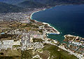 Aerial view of marina, cruise ship docks and downtown Puerto Vallarta
 -
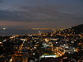 Puerto Vallarta at night
 -
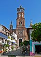 Closer view of the church
 -
A different angle of Our Lady of Guadalupe church
-
 The popular statue "El Caballito"
 -
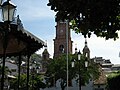 Parish Church of Our Lady of Guadalupe from the main plaza
 -
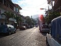 Typical cobbled street in Colonia Zapata
 -
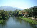 Rio Cuale south fork looking upstream from the pedestrian bridge at the mouth
 -
 Panoramic view of the hills and shore including the marina


References
Sources
- Link to tables of population data from Census of 2005 INEGI: Instituto Nacional de Estadística, Geografía e Informática
- Jalisco Enciclopedia de los Municipios de México
- Munguía Fregoso, Carlos - Panorama Histórico de Puerto Vallarta y de la Bahía de Banderas. Guadalajara (2003) Secretaría Cultura Jalisco
- Montes de Oca de Contreras, Catalina - Puerto Vallarta en mis recuerdos. Guadalajara (1982) Gobierno de Jalisco, Secretaria General, Unidad Editorial
- Guia Roji - Ciudad de Puerto Vallarta - Area Metropolitana Map 2005-6
- Moon Handbooks - Puerto Vallarta Emeryville, CA (2003) Avalon Travel Publishing
- Martínez Campos, Gabriel - Recetario comlimense de la iguana - Mexcio DF (2004) Conaculta
- Mantilla, Lucia - Los barrios pobres en 31 ciudades Mexicanas: Barrio Ramblases, Puerto Vallarta - Mexico (2004) Secretaria de Desarollo Social
- Harris, Richard - Hidden Puerto Vallarta Berkeley (2006) Ulysses Press
Notes
- ^ Census data is available from the website of the Mexican National Statistical Institute
- ^ Guia Roji - Ciudad de Puerto Vallarta (map)
- ^ Climate data taken from the Weather Underground site for 2001-2006.
- ^ Sector employment breakdown comes from the Jalisco state statistical encyclopedia listed in the reference section. Data is for the year 2000.
- ^ Since January 2006 Acapulco has seen a dramatic rise in drug related gun battles. See e.g. The San Diego Union-Tribune February 15, 2006 Acapulco's Loss of Innocence
- ^ Cuaderno Estadistico Municipal (2000) H. Ayuntamiento de Puerto Vallarta
- ^ The SEAPAL site lists water quality reports and a recurring theme is that while sewage facilities are available many buildings still discharge untreated sewage directly into to the bay and rivers. For the linkage between nutrient runoff and jellyfish blooms see the section on jellyfish blooms in the Wikipedia article about jellyfish.
- ^ "Las playas de Jalisco están entre las más sucias del país", El Informador de Guadalajara, July 4, 2007
- ^ "Boca de Tomatlán, una de las playas más contaminada de Jalisco", El Informador de Guadalajara, July 24, 2007 - the test results were 329 org/dl at Conchas Chinas and 259 org/dl at Los Muertos, both are measures of enteroccocal bacteria, and the US EPA's limit is 35 org/dl.
- ^ Mantilla Barrios Pobres p 16
- ^ Cuaderno Estadistico Municipal 2000
- ^ http://www.mexicanlaws.com/Minwages2005.htm
- ^ This is a simple observed fact: high profile projects like those mentioned succeed while year after year little changes in the poorer colonias where basic services continue to be lacking.
- ^ Compare a map of the city in 1990 to one from 2006 and you will see dozens of new fraccionamientos (housing projects) developed to help absorb the influx of workers
- ^ For a sense of the extent even of the city's modern history, note that Puerto Vallarta and Seattle were founded in the same year 1851.
- ^ the archaeologist in charge of these digs maintains a website with information related to them (in Spanish), one for the Ixtapasite, and one for the Calle Costa Rica site.
- ^ An example of this neglect is the City of Puerto Vallarta's destruction of the active excavation in the area of Calle Costa Rica and the Libramiento in 1995 to create a soccer field. See the website of the archeologist who led the dig for details.
- ^ Munguia Fregoso - Panorámica p. 66
- ^ Munguia Fregoso - Panorámica p. 68
- ^ Munguia Fregoso - Panorámica p. 82
- ^ Read almost any issue of the local newspapers and you will see an endless procession of complaints by the residents of outlying neighborhoods about poor road, sewage and water supply. See Munguia Fregoso - Panorámica p. 132-3 for the chronology that ties this situation to the peso devaluation crisis of the early 80s.
- ^ Airport information comes from the website of the Díaz Ordaz Airport
- ^ Munguia Fregoso - Panorama Histórico p. 100
- ^ Harris - Hidden p. 159
- ^ Harris - Hidden p. 175
- ^ Harris - Hidden p. 175
- ^ Harris - Hidden p. 192
- ^ Harris - Hidden p. 193
External links
- Puerto Vallarta official government site (in Spanish)
- University of Guadalajara in Puerto Vallarta (in Spanish)
- Puerto Vallarta's city run tourist site (In English)
- Puerto Vallarta at Wikitravel
it is know as the largest resort in mexico