
Cromer: Difference between revisions
Re Locate Photo: Cromer Views 23rd Oct 2007 |
m Repairing link to disambiguation page - You can help! - Wikipedia Cleaner 0.41 |
||
| Line 20: | Line 20: | ||
}} |
}} |
||
[[Image:Cromer Views 23rd Oct 2007 (1).JPG|thumb|left|220px|View over Cromer from the cliff tops near to Cromer Lighthouse.]] |
[[Image:Cromer Views 23rd Oct 2007 (1).JPG|thumb|left|220px|View over Cromer from the cliff tops near to Cromer Lighthouse.]] |
||
'''Cromer''' is a coastal [[town]] and [[Civil Parish]] located in the North of the [[English]] county of [[Norfolk]]. The Local Government authority is [[North Norfolk]] District Council whose Headquarters are in [[Holt]] road in the Town. The Town is situated 23 miles North of the County town of [[Norwich]], and is 4.2 miles west of the town of [[Sheringham]]. Road communications with Cromer are the [[A140 road|A140]] to Norwich, the [[A148 road|A148]] (Direct) & [[A149 road|A149]] (coast road) to Kings Lynn and the A149 into the [[Norfolk Broads]] and [[Great Yarmouth]]. The B1159 is a coastal road out towards [[Mundesley]]. The [[Cromer railway station|town]] is also on the [[Bittern Line]] connecting it to Sheringham, [[North Walsham railway station|North Walsham]], [[Hoveton and Wroxham railway station|Wroxham]] and [[Norwich railway station|Norwich]] from where the [[National Rail|national rail network]] can be accessed. The Nearest Airport is at [[Norwich International Airport|Norwich]]. The civil parish has an area of [[1 E6 m²|4.66 km²]] and in the [[United Kingdom Census 2001|2001 census]] had a population of 7749 in 3671 households. For the purposes of local government, the parish falls within the [[Non-metropolitan district|district]] of [[North Norfolk]].<ref name=osnncc>Office for National Statistics & Norfolk County Council (2001). ''[http://www.norfolk.gov.uk/consumption/groups/public/documents/general_resources/ncc017867.xls Census population and household counts for unparished urban areas and all parishes]''. Retrieved [[December 2]], [[2005]].</ref> |
'''Cromer''' is a coastal [[town]] and [[Civil Parish]] located in the North of the [[England|English]] county of [[Norfolk]]. The Local Government authority is [[North Norfolk]] District Council whose Headquarters are in [[Holt]] road in the Town. The Town is situated 23 miles North of the County town of [[Norwich]], and is 4.2 miles west of the town of [[Sheringham]]. Road communications with Cromer are the [[A140 road|A140]] to Norwich, the [[A148 road|A148]] (Direct) & [[A149 road|A149]] (coast road) to Kings Lynn and the A149 into the [[Norfolk Broads]] and [[Great Yarmouth]]. The B1159 is a coastal road out towards [[Mundesley]]. The [[Cromer railway station|town]] is also on the [[Bittern Line]] connecting it to Sheringham, [[North Walsham railway station|North Walsham]], [[Hoveton and Wroxham railway station|Wroxham]] and [[Norwich railway station|Norwich]] from where the [[National Rail|national rail network]] can be accessed. The Nearest Airport is at [[Norwich International Airport|Norwich]]. The civil parish has an area of [[1 E6 m²|4.66 km²]] and in the [[United Kingdom Census 2001|2001 census]] had a population of 7749 in 3671 households. For the purposes of local government, the parish falls within the [[Non-metropolitan district|district]] of [[North Norfolk]].<ref name=osnncc>Office for National Statistics & Norfolk County Council (2001). ''[http://www.norfolk.gov.uk/consumption/groups/public/documents/general_resources/ncc017867.xls Census population and household counts for unparished urban areas and all parishes]''. Retrieved [[December 2]], [[2005]].</ref> |
||
Revision as of 23:32, 23 October 2007
| Cromer | |
|---|---|
| File:Cromer Church 23rd Oct 2007 (1).JPG Cromer Parish Church. | |
| Population | 7,749 |
| OS grid reference | TG219422 |
| District | |
| Shire county | |
| Region | |
| Country | England |
| Sovereign state | United Kingdom |
| Postcode district | NR27 |
| Dialling code | 01263 |
| Police | Norfolk |
| Fire | Norfolk |
| Ambulance | East of England |
| UK Parliament | |
.JPG)
Cromer is a coastal town and Civil Parish located in the North of the English county of Norfolk. The Local Government authority is North Norfolk District Council whose Headquarters are in Holt road in the Town. The Town is situated 23 miles North of the County town of Norwich, and is 4.2 miles west of the town of Sheringham. Road communications with Cromer are the A140 to Norwich, the A148 (Direct) & A149 (coast road) to Kings Lynn and the A149 into the Norfolk Broads and Great Yarmouth. The B1159 is a coastal road out towards Mundesley. The town is also on the Bittern Line connecting it to Sheringham, North Walsham, Wroxham and Norwich from where the national rail network can be accessed. The Nearest Airport is at Norwich. The civil parish has an area of 4.66 km² and in the 2001 census had a population of 7749 in 3671 households. For the purposes of local government, the parish falls within the district of North Norfolk.[1]
Origins
Cromer is not mentioned in the Domesday Book of 1086, but two other settlements, Shipden-juxta-mere and Shipden-juxta-Felbrigg, are mentioned. It is reasonable to assume that the present site of Cromer, round the parish church of St Peter and St Paul, is what was then Shipden-juxta-Felbrigg.[citation needed] The other Shipden is now about four hundred metres to the north-east of the end of Cromer Pier, under the sea. Its site is marked by 'Church Rock', now no longer visible, even at a low spring tide. In 1888 a vessel struck the rock, and the rock was then blown up, in order that it did not remain as a hazard to shipping.
Cromer became a resort in the early 19th century, with a few of the rich Norwich banking families making it their summer home. In 1883 the London journalist Clement Scott, no doubt with the encouragement of the Great Eastern Railway Company (GER), came to Cromer and began to write about the area. He named the stretch of coastline, particularly the Overstrand and Sidestrand area, "Poppyland", and the combination of the railway and his writing in the national press brought many visitors. The name "Poppyland" referred to the numerous poppies which grew (and still do) at the roadside and in meadows, these were the wild remains of the opium poppies that had previously been commercially cultivated in this part of Norfolk. [citation needed]
Railway
The first railway had come in 1877, and ten years later a second station was opened, bringing visitors from the east midlands. The two stations were Cromer High (owned by GER) and the more central Cromer Beach (owned by the Midland and Great Northern Joint Railway), of which the latter still remains (now known simply as Cromer). Direct services were operated from London, Manchester, Leicester, Birmingham, Leeds, Peterborough and Sheffield, but today a solitary shuttle service to Norwich is all that remains. Although remote from London, Cromer had become a celebrated resort, including such visitors as the future King Edward VII, who played golf there. The town has a late Victorian pier which is home to the Pavilion Theatre,Cromer Pier
Cromer crab
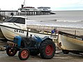
The town was, and is, famous for the Cromer crab, which forms the major source of income for the town's fishermen. The town had grown up as a fishing station over the centuries, and into the 20th century it was a year-round fishery, with crabs and lobsters in the summer, drifting for longshore herring in the autumn and long lining primarily for cod in the winter, when the weather permitted. The pattern of fishing has changed over the last thirty years, and it is now almost completely focussed on crabs and lobsters. From the beaches to the east and west of the pier being crowded with fishing boats at the end of the 19th century, about 10 boats now ply their trade from the foot of the gangway on the east beach. Four shops in town continue to operate and sell fresh crab, whenever the boats can get to sea.
Lifeboat
The fishermen were also renowned for manning Cromer's two lifeboats. Most famous of the lifeboatmen was Henry Blogg, who received the RNLI gold medal for heroism three times, and the silver medal four times. Cromer lifeboat station was founded in 1804, the first in Norfolk, and a series of rowing lifeboats was stationed there through the 19th century. In the 1920s a lifeboat station was built at the end of the pier, enabling a motor lifeboat to be launched beyond the breakers. A number of notable rescues carried out between 1917 and 1941 made the lifeboat and the town well-known throughout the United Kingdom and further afield. The area covered by the station is vast, as there a long run of coastline with no harbour - Great Yarmouth is 40 miles by sea to the south-east and the restricted harbour of Wells 25 miles to the west. Today the offshore lifeboat on the pier undertakes about a dozen services a year, with about the same number for the inshore lifeboat stationed on the beach.
Gallery
-
 Cromer Pier as seen from the Henry Blogg Museum.
 -
 Beaches and cliffs east of Cromer in the summer.
 -
 Cromer Lighthouse.
 -
 Cromer Museum.
 -
 Henry Blogg's Bronze Bust on the Cliff Top in North Lodge Park, Cromer.
 -
 View of Cromer Down the A148 road.
 -
 Ticket for the Pavilion Theatre on Cromer Pier, Show: The Manfreds.
 -
Cromer Pavilion Theatre on the end of Cromer Pier.


.JPG)
Notable people
- Henry Blogg, the Greatest of the Lifeboatmen.
- Benjamin Bond Cabbell, British Politician and Philanthropist
- James Dyson, Creator of Dyson Vacuum Cleaners.
- John Henry Gurney, English Banker and Amateur Ornithologist.
- Charles William Peach, British Naturalist and Geologist.
- Keith Skipper, Journalist who Writes for the Eastern Daily Press.
- Charles Mayes Wigg, English Artist.
Further reading
- Cromer - Chronicle of a Watering Place, Warren, M., Pub: Poppyland Publishing, Third edn. 2001, ISBN 0-946148-55-4
- The Cromer Lifeboats, Malster, R., Pub: Poppyland Publishing, Fourth Edn., 1994, ISBN 0-946148-21-X
- Poppyland - Strands of Norfolk History, Stibbons and Cleveland, Fourth Edn., 2001, ISBN 0-946148-17-1
- Cromer Lifeboats 1804-2004, Leach, Nicholas & Russell, Paul, Tempus Publishing, 2004, ISBN 0-7524-3197-8
References
- ^ Office for National Statistics & Norfolk County Council (2001). Census population and household counts for unparished urban areas and all parishes. Retrieved December 2, 2005.
See also
- Cromer Pier
- Cromer railway station
- Cromer Tunnel
- Cromer Ridge
- Cromer High School
- Cromer High railway station
- Cromer Town F.C.
- Henry Blogg
- A149 road
- A148 road
External links
- Map sources for Cromer.
- Information from Genuki Norfolk on Cromer.
- Empress Elizabeth and Cromer
- Cromer Lifeboat Station - Official Website