Castillejo de Mesleón: Difference between revisions
Content deleted Content added
m rm overlink, cleanup using AWB |
JJMC89 bot (talk | contribs) Migrate {{Infobox settlement}} coordinates parameters to {{Coord}}, see Wikipedia:Coordinates in infoboxes |
||
| Line 34: | Line 34: | ||
utc_offset_DST = +2 | |
utc_offset_DST = +2 | |
||
postal_code_type = Postal code| |
postal_code_type = Postal code| |
||
postal_code = 40593 |
postal_code = 40593 |
||
|coordinates = {{coord|41|16|50|N|3|36|5|W|display=inline}} |
|||
latd =41|latm=16|lats=50|latNS=N | |
|||
| |
|||
longd=3|longm=36 |longs=5|longEW=W | |
|||
website = | |
website = | |
||
footnotes = | |
footnotes = | |
||
Revision as of 19:15, 14 March 2017
Castillejo de Mesleón | |
|---|---|
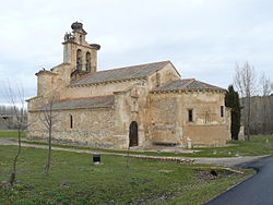
 Church of Nuestra Señora de la Asunción. | |
| Coordinates: 41°16′50″N 3°36′5″W / 41.28056°N 3.60139°W | |
| Country | Spain |
| Autonomous community | Castile and León |
| Province | Segovia |
| Comarca | Villa y Tierra de Sepúlveda |
| Government | |
| • Mayor | Ricardo Díez Pascual |
| Area | |
| • Total | 27.24 km2 (10.52 sq mi) |
| Elevation | 1,003 m (3,291 ft) |
| Population (2010) | |
| • Total | 158 |
| • Density | 5.8/km2 (15/sq mi) |
| Demonym | Castillejanos |
| Time zone | UTC+1 (CET) |
| • Summer (DST) | UTC+2 (CEST) |
| Postal code | 40593 |
Castillejo de Mesleón is a municipality located in the province of Segovia, Castile and León, Spain.
41°17′N 3°36′W / 41.283°N 3.600°W

