
Fuentidueña
| Fuentidueña municipality | |||
|---|---|---|---|
 Fuentidueña - the townscape
|
|||
| coat of arms | Map of Spain | ||
 Help on coat of arms |
|
||
| Basic data | |||
| Autonomous Community : |
|
||
| Province : | Segovia | ||
| Comarca : | Comunidad de villa y tierra de Fuentidueña | ||
| Coordinates | 41 ° 27 ′ N , 3 ° 59 ′ W | ||
| Height : | 870 msnm | ||
| Area : | 50.55 km² | ||
| Residents : | 147 (Jan. 1, 2019) | ||
| Population density : | 2.91 inhabitants / km² | ||
| Postal code : | 40357 | ||
| Municipality number ( INE ): | 40092 | ||
| administration | |||
| Website : | Fuentidueña | ||

Fuentidueña is a place and a municipality ( municipio ) with 147 inhabitants (as of January 1, 2019) in the central Spanish province of Segovia in the autonomous community of Castile and León . Due to the large number of historical buildings, the place was classified as a cultural asset ( Bien de Interés Cultural ) in the category Conjunto histórico-artístico in 1997 .
Location and climate
The place Fuentidueña is located on a mountain slope at an altitude of about 860 to 890 m on the Río Duratón about 33 km (driving distance) northwest of the small town of Sepúlveda . The distance to the provincial capital Segovia is about 73 km to the south. The climate is temperate to warm; Rain (approx. 460 mm / year) falls throughout the year, with the exception of the dry summer months.
Population development
| year | 1857 | 1900 | 1950 | 2000 | 2017 |
| Residents | 327 | 453 | 562 | 181 | 141 |
As a result of the increasing mechanization of agriculture , the abandonment of many small farms and the resulting loss of jobs in the countryside, the place has lost a lot of inhabitants since the middle of the 20th century.
economy
The place lives mainly from agriculture (agriculture) and tourism (rental of holiday apartments).
history

.jpg)

The place was not insignificant in the Middle Ages - an inscription carved in a stone commemorates a battle against the army of Almansor in 1002 immediately before their defeat at Calatañazor . Possibly a castle (castillo) was already standing at this time , which was later expanded under Alfonso VIII and his successors and occupies a whole hilltop. The high Middle Ages are considered to be the heyday of the place - several Romanesque churches were built during this time.
Attractions
- The townscape is characterized by partially built-over alleys with balcony porches resting on supports (soportales) .
- The old parish church (Iglesia de Santa María) in the center of the village is originally a late Romanesque building from the 13th century, but it was changed at a later date and is no longer used today because of its ruinous condition. You can see the Romanesque apse , two portals and some remains of the capital washed out by rain and wind .
- A medieval bridge, which was repeatedly restored in later times, spans the Río Duratón.
- The half above-ground storage cellars ( bodegas ) made of large and small stones are also worth seeing . The rear part is driven into the soil interspersed with field stones , which means that a constant temperature of around 10 ° C to 15 ° C is achieved in summer and winter.
- Above the village stands the Romanesque church of San Miguel , which now serves as the parish church, with its originally preserved apse with figural capitals and consoles and a restored south porch with double and quadruple columns ( portico or galería porticada) .
- New York, USA
- The well-preserved apse of St. Martin (San Martín) of a nearby Cistercian monastery , which was abandoned in the 17th or 18th century, was sold to the USA in 1957 - despite its classification as a national cultural asset ( Bien de Interés Cultural ) - and is now in Museum The Cloisters in New York , where the completely renovated church interior is used for services and concerts. Only the ruins of the outer walls of the nave, made of quarry stones (mampostería), and the remains of an excavated medieval cemetery (necrópolis) exist on the spot .

Bridge over the Río Duratón
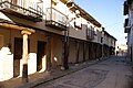
Street with protruding balconies
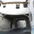
Overbuilding

Stone cellar ( bodegas )


Web links
- Fuentidueña, Miscellaneous - Photo + info (Spanish)
- Romanesque churches in Fuentidueña and surroundings - photos + information (Spanish)
Individual evidence
- ↑ Cifras oficiales de población resultantes de la revisión del Padrón municipal a 1 de enero . Population statistics from the Instituto Nacional de Estadística (population update).
- ↑ Fuentidueña - climate tables
- ↑ Fuentidueña - population development
- ^ Fuentidueña / New York - Apse of the Church of San Martín
Abades | Adrada de Pirón | Adrados | Aguilafuente | Alconada de Maderuelo | Aldea Real | Aldealcorvo | Aldealengua de Pedraza | Aldealengua de Santa María | Aldeanueva de la Serrezuela | Aldeanueva del Codonal | Aldeasoña | Aldehorno | Aldehuela del Codonal | Aldeonte | Anaya | Añe | Arahuetes | Arcones | Arevalillo de Cega | Armuña | Ayllón | Barbolla | Basardilla | Bercial | Bercimuel | Bernardos | Bernuy de Porreros | Boceguillas | Brieva | Caballar | Cabañas de Polendos | Cabezuela | Calabazas de Fuentidueña | Campo de San Pedro | Cantalejo | Cantimpalos | Carbonero el Mayor | Carrascal del Río | Casla | Castillejo de Mesleón | Castro de Fuentidueña | Castrojimeno | Castroserna de Abajo | Castroserracín | Cedillo de la Torre | Cerezo de Abajo | Cerezo de Arriba | Chañe | Cilleruelo de San Mamés | Cobos de Fuentidueña | Coca | Codorniz | Collado Hermoso | Condado de Castilnovo | Corral de Ayllón | Cozuelos de Fuentidueña | Cubillo | Cuéllar | Cuevas de Provanco | Domingo García | Donhierro | Duruelo | Encinas | Encinillas | Escalona del Prado | Escarabajosa de Cabezas | Escobar de Polendos | El Espinar | Espirdo | Fresneda de Cuéllar | Fresno de Cantespino | Fresno de la Fuente | Frumales | Fuente de Santa Cruz | Fuente el Olmo de Fuentidueña | Fuente el Olmo de Íscar | Fuentepelayo | Fuentepiñel | Fuenterrebollo | Fuentesaúco de Fuentidueña | Fuentesoto | Fuentidueña | Gallegos | Garcillán | Gomezserracín | Grajera | Honrubia de la Cuesta | Hontalbilla | Hontanares de Eresma | Los Huertos | Ituero y Lama | Juarros de Riomoros | Juarros de Voltoya | Labajos | Laguna de Contreras | Languilla | Lastras de Cuéllar | Lastras del Pozo | La Lastrilla | La Losa | Maderuelo | Marazoleja | Marazuela | Martín Miguel | Martín Muñoz de la Dehesa | Martín Muñoz de las Posadas | Marugán | Mata de Cuéllar | Matabuena | La Matilla | Melque de Cercos | Membibre de la Hoz | Migueláñez | Montejo de Arévalo | Montejo de la Vega de la Serrezuela | Monterrubio | Moral de Hornuez | Mozoncillo | Muñopedro | Muñoveros | Nava de la Asunción | Navafría | Navalilla | Navalmanzano | Navares de Ayuso | Navares de Enmedio | Navares de las Cuevas | Navas de Oro | Navas de Riofrío | Navas de San Antonio | Nieva | Olombrada | Orejana | Ortigosa de Pestaño | Ortigosa del Monte | Otero de Herreros | Pajarejos | Palazuelos de Eresma | Pedraza | Pelayos del Arroyo | Perosillo | Pinarejos | Pinarnegrillo | Pradales | Prádena | Puebla de Pedraza | Rapariegos | Rebollo | Remondo | Riaguas de San Bartolomé | Riaza | Ribota | Riofrío de Riaza | Roda de Eresma | Sacramenia | Samboal | San Cristóbal de Cuéllar | San Cristóbal de la Vega | San Cristóbal de Segovia | San Ildefonso | San Martín y Mudrián | San Miguel de Bernuy | San Pedro de Gaíllos | San Rafael | Sanchonuño | Sangarcía | Santa María la Real de Nieva | Santa Marta del Cerro | Santiuste de Pedraza | Santiuste de San Juan Bautista | Santo Domingo de Pirón | Santo Tome del Puerto | Sauquillo de Cabezas | Sebúlcor | Segovia | Sepúlveda | Sequera de Fresno | Sotillo | Sotosalbos | Tabanera la Luenga | Tolocirio | Torre Val de San Pedro | Torreadrada | Torrecaballeros | Torrecilla del Pinar | Torreiglesias | Trescasas | Turégano | Urueñas | Valdeprados | Valdevacas de Montejo | Valdevacas y Guijar | Valle de Tabladillo | Vallelado | Valleruela de Pedraza | Valleruela de Sepúlveda | Valseca | Valtiendas | Valverde del Majano | Veganzones | Vegas de Matute | Ventosilla y Tejadilla | Villacastín | Villaverde de Íscar | Villaverde de Montejo | Villeguillo | Yanguas de Eresma | Zarzuela del Monte | Zarzuela del Pinar