
Coca (Spain)
| Coca community | |||
|---|---|---|---|
.jpg) Coca - View of the town with the Iglesia de Santa María la Mayor and the bell tower of San Nicolás
|
|||
| coat of arms | Map of Spain | ||
.svg)
|
|
||
| Basic data | |||
| Autonomous Community : |
|
||
| Province : | Segovia | ||
| Coordinates | 41 ° 13 ′ N , 4 ° 31 ′ W | ||
| Height : | 785 msnm | ||
| Area : | 98.45 km² | ||
| Residents : | 1,763 (Jan 1, 2019) | ||
| Population density : | 17.91 inhabitants / km² | ||
| Postal code : | 40480 | ||
| Municipality number ( INE ): | 40057 | ||
| administration | |||
| Website : | Coca | ||

Coca is a small town and a municipality (municipio) with 1,763 inhabitants (as of January 1, 2019) in the central Spanish province of Segovia in the autonomous community of Castile and León . The city is recognized as a cultural asset ( Bien de Interés Cultural ) in the Conjunto histórico-artístico category .
Location and climate
The small town of Coca is located in the Castilian Meseta at an altitude of approx. 785 m and approximately halfway between Valladolid and Segovia . The climate is temperate to warm; Rain (approx. 400 mm / year) falls throughout the year, with the exception of the dry summer months.
Population development
| year | 1857 | 1900 | 1950 | 2000 | 2018 |
| Residents | 723 | 1,409 | 1,898 | 1,968 | 1,774 |
The mechanization of agriculture , the abandonment of small farms and the resulting loss of jobs in the countryside have led to a slight increase in the population in most cities since the middle of the 20th century.
economy
Coca is traditionally agriculturally oriented, but small traders, craftsmen and service providers have also settled in town. The city used to make a living from glass production . Today tourism plays an important economic role in the form of the rental of holiday apartments (casas rurales) because of the nearby Coca Castle .
history
Traces of human settlement go back to the Bronze Age. The Celtiberians had one of the largest settlements in the Duero catchment area . The place is said to have had about 7,000 inhabitants at that time. The settlement, which belonged to the settlement area of the Arevacians , was strategically well protected by the two rivers Eresma and Voltoya , which surround the place to the west and east. Around 220 BC The Carthaginian general Hannibal moved through this area. As a result, it came under the rule of the Romans , whose consul Lucius Licinius Lucullus the local resistance in 151 BC. B.C. could break what Appian reports. The Romans called the place, which grew to 20,000 inhabitants, Cauca . One of the most important roads on the Iberian Peninsula , the route from Galicia to central Castile, also touched the city at that time. Cauca was hit hard again by the campaigns against Sertorius (74 BC), but then flourished again. In the second century it was a Roman municipium . Especially in late antiquity , Cauca was home to important Roman noble families, for example, the emperor Theodosius I was born here in 347. With the invasion of the Visigoths in the 5th century, the importance of the place declined rapidly. From about 712 Coca belonged to the sphere of influence of the Moors until Alfonso VI. of Castile recaptured the city in 1085. In the 15th century, Coca was owned by Don Íñigo López de Mendoza, Marqués de Santillana and then (1453) it came to the Bishop Alonso de Fonseca I , who was at times also adviser to the Castilian kings John II and Henry IV and in Coca had a citadel built. Napoleon also stationed a garrison in this castle from 1808.
Attractions

- The town's landmark is the castle (castillo) , construction of which began by Moorish craftsmen in 1453 and was completed at the beginning of the 16th century. The core structure is surrounded by two crenellated walls made of brick , the flanks of which are protected by numerous round towers .
- Numerous remains of ancient buildings bear witness to the city's Roman past.
- The medieval city walls are also impressive.
- Two Celtic animal figures ( verracos ) are set up at the large city gate ; another is at the castle.
- The late Gothic Iglesia Santa Maria la Mayor was completed in 1520. The nave is covered by a star vault .
- The multi-storey bell tower (campanario) of the destroyed Church of San Nicolás is visible from afar . While the lower part consists of quarry stone masonry, the upper part is entirely made of bricks in Mudejar style .
- The Hospital de Nuestra Señora de la Merced is first mentioned in 1442. In 1907 it was completely restored.
- More recent are the imposing town hall (ayuntamiento) and the Centro cultural Fonseca .
- Surroundings
- About a kilometer northeast of the city is the Ermita de Santa Rosalia , built in the 18th century .

City wall (muralla)
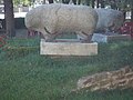
celtic verraco figures

Iglesia de Santa Maria la Mayor

Torre San Nicolás

Hospital de la Merced

Town hall (ayuntamiento)

.jpg)


.jpg)

literature
- Reinhart Wolf . With texts by Cees Nooteboom : Castillos, castles in Spain . Schirmer / Mosel Verlag , Munich 2001, ISBN 3-8296-0026-7 , pp. 16, 111, fig. 29
- Leonardy, Heribert J., Hendrik Kersten: Castles in Spain. A trip to the Spanish Middle Ages . Darmstadt, Wissenschaftliche Buchgesellschaft 2002, pp. 158–162
Web links
- Coca, sights - photos + information (arteguias, spanish)
- Coca, sights - photos + information (Spanish)
Individual evidence
- ↑ Cifras oficiales de población resultantes de la revisión del Padrón municipal a 1 de enero . Population statistics from the Instituto Nacional de Estadística (population update).
- ↑ Coca - climate tables
- ↑ Coca - population development
- ↑ Coca story
- ↑ Coca - Castillo
- ↑ Coca - city wall
Abades | Adrada de Pirón | Adrados | Aguilafuente | Alconada de Maderuelo | Aldea Real | Aldealcorvo | Aldealengua de Pedraza | Aldealengua de Santa María | Aldeanueva de la Serrezuela | Aldeanueva del Codonal | Aldeasoña | Aldehorno | Aldehuela del Codonal | Aldeonte | Anaya | Añe | Arahuetes | Arcones | Arevalillo de Cega | Armuña | Ayllón | Barbolla | Basardilla | Bercial | Bercimuel | Bernardos | Bernuy de Porreros | Boceguillas | Brieva | Caballar | Cabañas de Polendos | Cabezuela | Calabazas de Fuentidueña | Campo de San Pedro | Cantalejo | Cantimpalos | Carbonero el Mayor | Carrascal del Río | Casla | Castillejo de Mesleón | Castro de Fuentidueña | Castrojimeno | Castroserna de Abajo | Castroserracín | Cedillo de la Torre | Cerezo de Abajo | Cerezo de Arriba | Chañe | Cilleruelo de San Mamés | Cobos de Fuentidueña | Coca | Codorniz | Collado Hermoso | Condado de Castilnovo | Corral de Ayllón | Cozuelos de Fuentidueña | Cubillo | Cuéllar | Cuevas de Provanco | Domingo García | Donhierro | Duruelo | Encinas | Encinillas | Escalona del Prado | Escarabajosa de Cabezas | Escobar de Polendos | El Espinar | Espirdo | Fresneda de Cuéllar | Fresno de Cantespino | Fresno de la Fuente | Frumales | Fuente de Santa Cruz | Fuente el Olmo de Fuentidueña | Fuente el Olmo de Íscar | Fuentepelayo | Fuentepiñel | Fuenterrebollo | Fuentesaúco de Fuentidueña | Fuentesoto | Fuentidueña | Gallegos | Garcillán | Gomezserracín | Grajera | Honrubia de la Cuesta | Hontalbilla | Hontanares de Eresma | Los Huertos | Ituero y Lama | Juarros de Riomoros | Juarros de Voltoya | Labajos | Laguna de Contreras | Languilla | Lastras de Cuéllar | Lastras del Pozo | La Lastrilla | La Losa | Maderuelo | Marazoleja | Marazuela | Martín Miguel | Martín Muñoz de la Dehesa | Martín Muñoz de las Posadas | Marugán | Mata de Cuéllar | Matabuena | La Matilla | Melque de Cercos | Membibre de la Hoz | Migueláñez | Montejo de Arévalo | Montejo de la Vega de la Serrezuela | Monterrubio | Moral de Hornuez | Mozoncillo | Muñopedro | Muñoveros | Nava de la Asunción | Navafría | Navalilla | Navalmanzano | Navares de Ayuso | Navares de Enmedio | Navares de las Cuevas | Navas de Oro | Navas de Riofrío | Navas de San Antonio | Nieva | Olombrada | Orejana | Ortigosa de Pestaño | Ortigosa del Monte | Otero de Herreros | Pajarejos | Palazuelos de Eresma | Pedraza | Pelayos del Arroyo | Perosillo | Pinarejos | Pinarnegrillo | Pradales | Prádena | Puebla de Pedraza | Rapariegos | Rebollo | Remondo | Riaguas de San Bartolomé | Riaza | Ribota | Riofrío de Riaza | Roda de Eresma | Sacramenia | Samboal | San Cristóbal de Cuéllar | San Cristóbal de la Vega | San Cristóbal de Segovia | San Ildefonso | San Martín y Mudrián | San Miguel de Bernuy | San Pedro de Gaíllos | San Rafael | Sanchonuño | Sangarcía | Santa María la Real de Nieva | Santa Marta del Cerro | Santiuste de Pedraza | Santiuste de San Juan Bautista | Santo Domingo de Pirón | Santo Tome del Puerto | Sauquillo de Cabezas | Sebúlcor | Segovia | Sepúlveda | Sequera de Fresno | Sotillo | Sotosalbos | Tabanera la Luenga | Tolocirio | Torre Val de San Pedro | Torreadrada | Torrecaballeros | Torrecilla del Pinar | Torreiglesias | Trescasas | Turégano | Urueñas | Valdeprados | Valdevacas de Montejo | Valdevacas y Guijar | Valle de Tabladillo | Vallelado | Valleruela de Pedraza | Valleruela de Sepúlveda | Valseca | Valtiendas | Valverde del Majano | Veganzones | Vegas de Matute | Ventosilla y Tejadilla | Villacastín | Villaverde de Íscar | Villaverde de Montejo | Villeguillo | Yanguas de Eresma | Zarzuela del Monte | Zarzuela del Pinar