Novi Banovci: Difference between revisions
CalliopeMuse (talk | contribs) m typo |
|||
| (3 intermediate revisions by 3 users not shown) | |||
| Line 16: | Line 16: | ||
| mapsize = |
| mapsize = |
||
| map_caption = |
| map_caption = |
||
| pushpin_map = Serbia |
| pushpin_map = Serbia Vojvodina#Serbia#Europe |
||
| pushpin_label_position = bottom |
| pushpin_label_position = bottom |
||
| pushpin_mapsize = |
| pushpin_mapsize = |
||
| Line 67: | Line 67: | ||
==Name== |
==Name== |
||
The name of the town in [[Serbian language|Serbian]] is |
The name of the town in [[Serbian language|Serbian]] is plural. |
||
==History== |
==History== |
||
Following the Roman conquest in the 1st century BC, the settlement was known as '''Burgenae'''.<ref>{{Cite web|url=https://turizampazova.rs/arheoloski-lokaliteti/|title=Arheološki lokaliteti Istorijat {{!}} Turistička organizacija opštine Stara Pazova|language=sr-RS|access-date=2020-03-30}}</ref> <!-- An important fortification (500 x 600 m), the residence of ''Cohors I Thracum civium Romanorum'', civil settlement, necropolis has been excavated. In late antiquity, according to Notitia, ''cuneus equitum Constantianarum'', a part of [[Legio V Iovia]] as well as ''equites Dalmatae'' were stationed here.<ref>http://old.perseus.tufts.edu/cgi-bin/ptext?doc=Perseus:text:1999.04.0006&query=id%3D%231514</ref> --> |
Following the Roman conquest in the 1st century BC, the settlement was known as '''Burgenae'''.<ref>{{Cite web|url=https://turizampazova.rs/arheoloski-lokaliteti/|title=Arheološki lokaliteti Istorijat {{!}} Turistička organizacija opštine Stara Pazova|language=sr-RS|access-date=2020-03-30}}</ref> <!-- An important fortification (500 x 600 m), the residence of ''Cohors I Thracum civium Romanorum'', civil settlement, necropolis has been excavated. In late antiquity, according to Notitia, ''cuneus equitum Constantianarum'', a part of [[Legio V Iovia]] as well as ''equites Dalmatae'' were stationed here.<ref>http://old.perseus.tufts.edu/cgi-bin/ptext?doc=Perseus:text:1999.04.0006&query=id%3D%231514 {{Dead link|date=March 2022}}</ref> --> |
||
The village of Novi Banovci was established in 1790 and soon it turned into the first predominantly [[Lutheran]] village within the boundaries of the [[Military Frontier]].<ref name="Bogišić">{{cite book |author1=Lidija Barišić Bogišić |chapter=Njemački jezik u Srijemskoj županiji u popisu stanovništva 1910. godine |title=O neslavenskom stanovništvu na vukovarskom području |publisher=Hrvatska sveučilišna naklada |ISBN= 978-953-169-497-1 |pages=39-40 |date=2022 }}</ref> |
|||
Novi Banovci experienced a constant population growth in the 20th century. A significant increase in the neighborhood's population occurred in the mid-1990s, caused by the large influx of refugees from the [[Yugoslav War]], especially after the [[Operation Storm|Oluja military action]] which forced almost 250,000 Serbs from [[Croatia]] into Serbia, and many of them settled at the outskirts of Belgrade. |
Novi Banovci experienced a constant population growth in the 20th century. A significant increase in the neighborhood's population occurred in the mid-1990s, caused by the large influx of refugees from the [[Yugoslav War]], especially after the [[Operation Storm|Oluja military action]] which forced almost 250,000 Serbs from [[Croatia]] into Serbia, and many of them settled at the outskirts of Belgrade. |
||
Latest revision as of 23:22, 3 January 2023
Novi Banovci
Нови Бановци (Serbian) | |
|---|---|
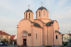
 The new Orthodox church dedicated to Saint Basil of Ostrog | |
| Coordinates: 44°57′N 20°17′E / 44.950°N 20.283°E | |
| Country | |
| Province | |
| Region | Syrmia |
| District | Srem |
| Municipality | Stara Pazova |
| Area | |
| • Total | 8.70 km2 (3.36 sq mi) |
| Population (2011) | |
| • Total | 9,443 |
| Time zone | UTC+1 (CET) |
| • Summer (DST) | UTC+2 (CEST) |
Novi Banovci (Serbian Cyrillic: Нови Бановци) is a settlement in Serbia by the Danube River. It is situated in the Stara Pazova municipality, in the Srem District, in Vojvodina province. It is located 5 kilometers away from Batajnica and 20 km from the capital, Belgrade. Novi Banovci is situated on the Belgrade-Novi Sad route. It has a Serb ethnic majority and its population totals 9,443 people (2011 census).[1]
Name[edit]
The name of the town in Serbian is plural.
History[edit]
Following the Roman conquest in the 1st century BC, the settlement was known as Burgenae.[2]
The village of Novi Banovci was established in 1790 and soon it turned into the first predominantly Lutheran village within the boundaries of the Military Frontier.[3]
Novi Banovci experienced a constant population growth in the 20th century. A significant increase in the neighborhood's population occurred in the mid-1990s, caused by the large influx of refugees from the Yugoslav War, especially after the Oluja military action which forced almost 250,000 Serbs from Croatia into Serbia, and many of them settled at the outskirts of Belgrade.
Demographics[edit]
Population of Novi Banovci according to the official censuses:[1]
- 1948: 1,341
- 1953: 1,451
- 1961: 1,592
- 1971: 1,842
- 1981: 4,077
- 1991: 6,354
- 2002: 9,358
- 2011: 9,443
See also[edit]
References[edit]
- ^ a b "Comparative overview of the number of population in 1948, 1953, 1961, 1971, 1981, 1991, 2002 and 2011" (PDF). Retrieved 11 May 2020.
- ^ "Arheološki lokaliteti Istorijat | Turistička organizacija opštine Stara Pazova" (in Serbian). Retrieved 2020-03-30.
- ^ Lidija Barišić Bogišić (2022). "Njemački jezik u Srijemskoj županiji u popisu stanovništva 1910. godine". O neslavenskom stanovništvu na vukovarskom području. Hrvatska sveučilišna naklada. pp. 39–40. ISBN 978-953-169-497-1.
- Slobodan Ćurčić, Broj stanovnika Vojvodine, Novi Sad, 1996.
External links[edit]
44°57′N 20°17′E / 44.950°N 20.283°E


