Tornavacas: Difference between revisions
Content deleted Content added
m Disambiguating links to Cáceres (link changed to Province of Cáceres) using DisamAssist. |
Undid revision 1111164406 by 213.194.154.216 (talk) |
||
| (2 intermediate revisions by 2 users not shown) | |||
| Line 6: | Line 6: | ||
| image_caption = View of Tornavacas |
| image_caption = View of Tornavacas |
||
| image_flag = Bandera_de_Tornavacas.svg |
| image_flag = Bandera_de_Tornavacas.svg |
||
| |
| image_shield = [[file:Escudo_de_Tornavacas.svg|70px]] |
||
| nickname = |
| nickname = |
||
| pushpin_map = Spain |
| pushpin_map = Spain |
||
Latest revision as of 19:49, 20 September 2022
You can help expand this article with text translated from the corresponding article in Spanish. (August 2011) Click [show] for important translation instructions.
|
Tornavacas | |
|---|---|
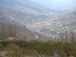
 View of Tornavacas | |
| Country | Spain |
| Autonomous community | Cáceres |
| Area | |
| • Total | 76.6 km2 (29.6 sq mi) |
| Elevation | 871 m (2,858 ft) |
| Population (2018)[1] | |
| • Total | 1,143 |
| • Density | 15/km2 (39/sq mi) |
| Time zone | UTC+1 (CET) |
| • Summer (DST) | UTC+2 (CEST) |
| Website | www.tornavacas.es |
Tornavacas is a municipality located in the province of Cáceres, in the autonomous community of Extremadura, Spain. The municipality covers an area of 595 square kilometres (230 sq mi) and as of 2011 had a population of 1170 people.[2]
References[edit]
- ^ Municipal Register of Spain 2018. National Statistics Institute.
- ^ "Cáceres: Población por municipios y sexo:Cifras oficiales de población resultantes de la revisión del Padrón municipal a 1 de enero de 2011". Instituto Nacional de Estadística. Retrieved 26 May 2012.
40°15′N 5°41′W / 40.250°N 5.683°W


