Åreälven
| Åreälven | ||
|
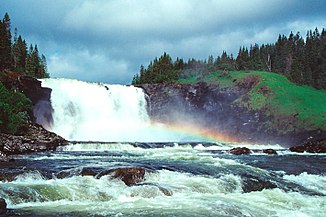
Tännforsen |
||
| Data | ||
| location | Jämtlands län ( Sweden ) | |
| River system | Indalsälven | |
| Drain over | Indalsälven → Baltic Sea | |
| River basin district | Bottenhavet | |
| origin | See Skalsvattnet 63 ° 35 '52 " N , 12 ° 13' 15" O |
|
| Source height | 555.2 m above sea level | |
| muzzle | See Liten Coordinates: 63 ° 20 ′ 2 " N , 13 ° 26 ′ 45" E 63 ° 20 ′ 2 " N , 13 ° 26 ′ 45" E |
|
| Mouth height | 317 m above sea level | |
| Height difference | 238.2 m | |
| Bottom slope | 3.4 ‰ | |
| length | 70 km | |
| Right tributaries | Gevsjöströmmen | |
| Flowing lakes | Åresjön | |
| Communities | Duved , Björnänge , Undersåker , Åre | |
| Waterfalls: Tännforsen , Ristafall | ||
The Åreälven River in the Swedish province of Jämtland is the main source of the Indalsälven .
It has its origin in the mountain lake Skalsvattnet , which lies on the Swedish-Norwegian border. From there it flows in an easterly direction. It flows through several smaller lakes, including the Tännsjön and Östra Noren . The 37 m high Tännfors waterfall lies between these two lakes . As far as Duved , Länsväg 322 runs largely along the course of the Åreälven. The river will then be accompanied by European route 14 to its confluence with Lake Liten at Järpen .
On his way he passes the villages Björnänge and Undersåker, which belong to the municipality of Åre . Shortly before its mouth, the Åreälven overcomes the Ristafall waterfall .
Individual evidence
- ↑ a b SMHI - Sjöareal och sjöhöjd (PDF; 3.5 MB)
