
Óbánya
| Óbánya | |||||
|
|||||
| Basic data | |||||
|---|---|---|---|---|---|
| State : | Hungary | ||||
| Region : | Southern Transdanubia | ||||
| County : | Baranya | ||||
| Small area until December 31, 2012 : | Pécsvárad | ||||
| District since 1.1.2013 : | Pécsvárad | ||||
| Coordinates : | 46 ° 13 ' N , 18 ° 24' E | ||||
| Area : | 7.49 km² | ||||
| Residents : | 130 (Jan. 1, 2011) | ||||
| Population density : | 17 inhabitants per km² | ||||
| Postal code : | 7695 | ||||
| KSH kódja: | 12645 | ||||
| Structure and administration (status: 2018) | |||||
| Community type : | local community | ||||
| Mayoress : | Irén van Groeningen (independent) | ||||
| Postal address : | Fő utca 71 7695 Óbánya |
||||
| Website : | |||||
| (Source: A Magyar Köztársaság helységnévkönyve 2011. január 1st at Központi statisztikai hivatal ) | |||||


Óbánya ( German Altglashütte ) is a Hungarian community in the county Pécsvárad in Baranya .
Geographical location
Óbánya is located in the eastern part of the Mecsek , about seven kilometers north of the city of Pécsvárad , on the small river Öreg-patak . The neighboring municipality of Mecseknádasd is five kilometers east of the village. The place belongs to Bricjaranya , a region with a German-speaking minority.
Attractions
- Village Museum ( Falumúzeum )
- Nature reserve Kelet-Mecsek Tájvédelmi Körzet
- Boldogságos Szűz Mária anyasága Roman Catholic Church , built in 1850
- Skóciai Szent Margit statue ( Skóciai Szent Margit ), created by Attila Tóth
traffic
Óbánya can only be reached via the side road no. 56194. The nearest train station is 11 kilometers northeast in Hidas - Bonyhád .
photos

Roman Catholic Boldogságos Church Szűz Mária anyasága
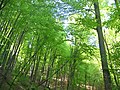
Forest area near Óbánya
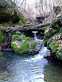
Öreg-patak


Web links
- Official website ( Hungarian )
- László Vass: Egy szelet Svájc a Mecsekben at origo.hu (Hungarian)