
Austrian plate
| Austrian plate | ||
|---|---|---|
 Austrian plate with the back of a donkey, in the left foreground the edge of the mine crater from the Italian blast on October 1, 1917 |
||
| height | 2203 m slm | |
| location | Pasubio , Trentino , Italy | |
| Mountains | Vicentine Alps | |
| Coordinates | 45 ° 47 '51 " N , 11 ° 10' 30" E | |
|
||
| rock | Main dolomite | |
| Age of the rock | Upper Triassic | |

The Austrian plate ( Italian Dente Austriaco ) is a 2203 m slm high side peak at the main ridge of the Pasubio - massif . Located in the Italian province of Trento on the border with the province of Vicenza , the summit, which is insignificant from an alpine perspective, formed the foremost Austro-Hungarian frontline on the Pasubio during World War I from 1916 to 1918 and is about 30 m away from the Italian plate , separated by a saddle .
geography
The Austrian plate, like the Italian plate to the south, belongs to the main ridge of the Pasubio. The approximately 200 m long and 80 m wide elevation is clearly demarcated from the rest of the ridge in the northwest and south by two small saddles. The back of the donkey (it. Selletta dei Denti ) forms the border to the Italian plate, while the nameless saddle in the north-west separates the Austrian plate from the so-called "nose" 2111 m slm , as the Italians called the war uprising. The steep flanks of the plate fall in the west to the Cosmagnon valley (it. Alpe di Cosmagnon ) and in the east to the valley Sette Croci (English: seven crosses). Like its Italian pedant, the Austrian record is characterized by numerous traces from the time of the First World War. Some commemorative plaques commemorate the Austro-Hungarian and Italian units and associations deployed here .

Remnants of the concreted Austro-Hungarian performance, behind it the Italian plate

North entrance into the Ellison Adit

Laufgraben on the Austrian plate

Memorial plaque of the Kaiserjäger on the so-called nose


history
Up until the Austro-Hungarian spring offensive in 1916 , the up to then nameless elevation on the main ridge of the Pasubio was insignificant. Due to a lack of defensive positions, a barricade planned by the Austro-Hungarian army before the war on the Pasubio was not implemented, the massif was cleared. The Austro-Hungarian forces had withdrawn to an easier defendable line of defense further west near Rovereto .
Only in the course of the offensive that broke out on May 15, 1916 was it possible to push back the Italian troops in the western and central area of the massif, which had advanced to the gates of Rovereto a year earlier after the Italian war . In the course of this advance, on May 20, advance guards of the 10th Austro-Hungarian Mountain Brigade, led by Colonel Brigadier Karl Korzer, occupied the Austrian plate, which at that time was still labeled Kote 2206.
From that day on, until the end of the war in November 1918, the Austrian plate formed the foremost Austro-Hungarian front line on the Pasubio. Even after the offensive was discontinued, the attempt to occupy the main summit of the massif, the Cima Palon about 300 m away, was not given up. On July 2, 1916, the plate served as a springboard for a major attack by the 10th Austro-Hungarian Mountain Brigade, reinforced by the 1st Tyrolean Kaiserjäger Regiment , on the Italian positions.
After the failed attack, it was again the Kaiserjäger who in the following autumn had to repel a whole series of attacks by the 44th Infantry Division led by General Andrea Graziani on the Platte and the neighboring sectors. During these attacks the Italians succeeded in penetrating the front positions on the Austrian plate, but were forced to retreat due to violent counter-attacks. In these attacks, which were carried out from mid-September to the end of October, both sides together reported around 11,500 dead, wounded and missing. In the last eleven days of the attack from October 9th to 20th, the casualties reached about 8,000 men over a front length of almost two kilometers, in the middle of which was the Austrian plate, before snowfall and the onset of winter made further attacks impossible.
For the successful defense of the plate, the plate commander, Lieutenant of the Reserve Viktor Oberguggenberger von der Kaiserjäger, was later awarded the highest military distinction of the Habsburg monarchy, the Order of Maria Theresa .
After these attacks, Colonel Ellison , who in the meantime had taken command of the Austro-Hungarian troops on the Pasubio, had the plate fortified. In addition to running and trenches also were kavernierte positions that were connected underground tunnels, most of them created. In the end, there was space in the plate for ten machine gun positions and six gun positions, which were distributed over two levels. Eighteen mortars , 12 grenade launchers , four flamethrowers , three 7.5 cm cannons and two 37 mm infantry guns had also been positioned on the plate . A drinking water cistern, a compressor room for the drill trains and the tunnel ventilation, an engine room, an electrical and a telephone switchboard and other utilities were again located underground.
The defense measures ordered by Ellison also included the excavation of an attack tunnel that was later named after him. With the construction, they wanted to counter attempts to undermine their own slab by the enemy and a possible demolition, such as at Col di Lana , in good time. For the construction of the tunnel, at the end of which several mine chambers were subsequently built, experts such as the sapper lieutenant Albin Mlaker , who had already successfully led the mine work on Monte Cimone near Arsiero, were consulted .
At the end of March 1917, the Ellison tunnel had already reached a length of 127 m, while no countermeasures had yet been taken on the Italian side. A temporal and spatial advantage that should always be on the Austro-Hungarian side until the end of the mine war. In the end, the attack tunnel should reach a total length of about 270 m and end under the Italian plate. 170 m after the tunnel entrance laid out on the rear side of the slab there was a stairway called the cathedral into the upper tunnel area of the slab, in which the supply facilities and cavernous positions were located.
On September 29, 1917, the first Austro-Hungarian mine was ignited under the Italian plate. Another four Austro-Hungarian mine explosions were to follow by March 1918, which the Italians in turn responded with five explosions, whereby they did not succeed in getting under the enemy tunnel system or in the vicinity of the Austrian plate.
For the last Austro-Hungarian mine blast on March 13, 1918, 50 tons of explosives were used, which were distributed over two mine chambers. The loading of the two chambers alone took a week, as the explosives were staggered in several depots behind the front line, with the last depot 10 km away from the Austrian Platte and transported to the Platte and into the Ellison Tunnels by cable cars and girders had to. The porters not only had to struggle with the 40 kg of explosives on their backs, but also with the adverse winter weather conditions.
The March 13 blast, which was the largest mine blast on the Italian front during World War I, caused the northern edge of the Italian plate and the tunnels below to collapse. Due to the rock that had become brittle as a result of the blast and the associated risk of collapse, both sides decided not to continue the mine war.
Up until the end of the war there were no more major infantry attacks against the Austrian plate. The latter was always the target of the Italian artillery. An Italian offensive planned in the summer of 1918 on the Pasubio did not materialize in the end. On November 1, 1918, the order to abandon the plate was given and the withdrawal ordered. On the night of November 2, 1918, the Kaiserjäger withdrew from the Austrian Platte, which they held from July 1916, which is why the Pasubio is also known as the Kaiserjägerberg.

Torn ventilation duct in the Ellison tunnel after a blast
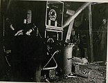
Machine hall in the cathedral of the Austrian plate

Entrance of the Putzker gallery

Ellison studs

Ascent from the Ellison tunnel to the cathedral

The cathedral in the Austrian Platte

Caverned gun emplacement in the Austrian plate
.jpg)
.jpg)


Ascent routes
The Austrian Platte can be reached from Rifugio Achille Papa on the Tricolore path (path no. 105) in just over an hour. It takes around two hours from the Rifugio Vincenzo Lancia . The plate is touched by the European long-distance hiking trail E5 and the Friedensweg , both of which coincide with the course of path no.105. Both the Ellison tunnel and the cathedral and the adjoining tunnel systems can be viewed with a torch.
literature
- Moritz Brunner: Two examples of mine fighting in the high mountains . In: Austrian Federal Ministry for the Army (ed.): Military-scientific and technical communications 1921 LII. Volume eleventh – twelfth issue . Vienna 1921.
- Ecomuseo Grande Guerra Prealpi Vicentine (ed.): Monte Pasubio. Marcolin, Schio 2014.
- Claudio Gattera, Roberto Greselin: Pasubio 1915–1918: Salvare la memoria. Graffiti della Grande Guerra nei campi di battaglia del Pasubio - Carega - Zugna - Vallarsa - Val Terragnolo - Val Posina - Monte Maio . Gino Rossato Editore, Valdagno 2008, ISBN 978-88-8130-110-2
- Karl Korzer: An attack in the rocky mountains. The fighting on the Pasubio June-July 1916 . In: Austrian Federal Ministry for the Army (Ed.): Military-scientific and technical communications 1930 LXI. Vintage March – April . Vienna 1930.
- Gianni Pieropan: Monte Pasubio: Guida alla Zona Sacra. Itinerari - Ambiente - Storia. Gino Rossato Editore, Valdagno 1990.
- Viktor Schemfil: Pasubio battles 1916/1918. Exact history of the struggle for one of the most important pillars of the Tyrolean defense front, based on Austrian field files and Italian war history works. Publisher E. Kienesberger, Nuremberg 1984.
- Robert Striffler: Le 34 mine fatte brillare sul fronte alpino tirolese 1916 - 1918 . In: Società Storica per la Guerra Bianca (ed.): Aquile in Guerra No. 1 , Rozzano 1993.
Web links
References and comments
- ↑ a b c Ecomuseo Grande Guerra Prealpi Vicentine (ed.): Monte Pasubio. o. S.
- ↑ Viktor Schemfil: Pasubio battles 1916/1918. Exact history of the struggle for one of the most important pillars of the Tyrolean defense front, based on Austrian field files and Italian war history works. P. 23
- ↑ Claudio Gattera, Roberto Greselin: Pasubio 1915-1918: Be Saved la memoria. Graffiti della Grande Guerra nei campi di battaglia del Pasubio - Carega - Zugna - Vallarsa - Val Terragnolo - Val Posina - Monte Maio pp. 63–64
- ↑ Viktor Schemfil: Pasubio battles 1916/1918. Exact history of the struggle for one of the most important pillars of the Tyrolean defense front, based on Austrian field files and Italian war history works. P. 171
- ↑ Viktor Schemfil: Pasubio battles 1916/1918. Exact history of the struggle for one of the most important pillars of the Tyrolean defense front, based on Austrian field files and Italian war history works. P. 224
- ↑ Claudio Gattera, Roberto Greselin: Pasubio 1915-1918: Be Saved la memoria. Graffiti della Grande Guerra nei campi di battaglia del Pasubio - Carega - Zugna - Vallarsa - Val Terragnolo - Val Posina - Monte Maio pp. 64–65
- ^ Moritz Brunner: Two examples about the mine fight in the high mountains, pp. 454–455
- ↑ Viktor Schemfil: Pasubio battles 1916/1918. Exact history of the struggle for one of the most important pillars of the Tyrolean defense front, based on Austrian field files and Italian war history works. Pp. 274-279
- ↑ 2000 also in German under the title: The 34 mine explosions on the Tyrolean mountain front 1916-1918 appeared in the magazine Fortification, issue 14.