
Italian plate
| Italian plate | ||
|---|---|---|
 Debris field of the Italian plate caused by the Austrian mine explosion on March 13, 1918 |
||
| height | 2220 m slm | |
| location | Pasubio , Trentino , Italy | |
| Mountains | Vicentine Alps | |
| Coordinates | 45 ° 47 '40 " N , 11 ° 10' 35" E | |
|
||
| rock | Dolomia Principale | |
| Age of the rock | Upper Triassic | |

The Italian plate ( Italian Dente Italiano ) is a 2220 m slm high side peak at the main ridge of the Pasubio - massif . Located on the border between the Italian provinces of Trento and Vicenza , the summit, which is insignificant from an alpine perspective, was a hard-fought mountain on the Alpine front during the First World War . The Italian Platte achieved particular fame through the mine warfare that was fought there between 1917 and 1918 , which significantly changed the appearance of the mountain. In 1922, the plate was declared a national memorial, the so-called Zona Sacra (Holy Zone).
geography
The Italian plate forms the northern ridge extension of the 2232 m slm high Cima Palon and is less than 200 m away as the crow flies. The approximately 20 m wide Damaggo saddle (it. Selletta Damaggio ) 2175 m slm separates the Italian plateau from the Cima Palon. To the west, the Alpe di Cosmagnon and to the east, Sette Croci, are two larger depressions of the Pasubio massif. The entire plate carries as the north bordering 2203 m slm high Austrian plate (ita. Dente Austriaco ) numerous traces of the battles of World War I as trenches , shell holes , remainders and tunnel entrances . Churned up by the war, the slab and the immediate vicinity resemble a stone desert, in which the vegetation has only partially regained a foothold even after a hundred years. The debris field at the northern tip of the Platte, which was caused by the last mine explosion on March 13, 1918, is particularly striking. The Italian plate is separated from the Austrian plate by a 30 m wide saddle, the so-called donkey's back, which during the war formed the no man's land between the two front lines. On the edge of the rubble field towards the Italian plate, the remains of the mine crater of the Italian demolition of October 1, 1917 can be seen on the back of the donkey.

Donkey back and Italian platter from the Austrian platter

Summit cross, in the background the northern Italian plain, destination of Austria-Hungary. Spring offensive 1916

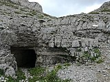
Eastern entrance to the upper Italian tunnel system

The Selletta Damaggio between Cima Palon (left) and Italienischer Platte (right) with the western entrance to the upper tunnel system


history
Immediately after the Italian declaration of war on 24 May 1915, the summit area of the Pasubio by a company of was Alpini - battalion Vicenza occupied without encountering resistance, as the Austro-Hungarian troops had withdrawn to more easily defensible positions. Until the spring of 1916, this area lay far behind the front line that ran further west near Rovereto . Only after the start of the Austro-Hungarian spring offensive in 1916 did the summit area of the Pasubio become a frontline area. By May 20, 1916, the vanguard of the 10th Austro-Hungarian Mountain Brigade managed to advance to within a few hundred meters of the main summit of the Cima Palon on Kote 2203, hereinafter referred to as the Austrian plate. An occupation of the Cima Palon, however, did not succeed, as this, like the unnamed Italian plate lying northwest in front of it, had been occupied the day before by hastily brought in Italian units of the Volturno Infantry Brigade belonging to the 1st Army . Some subsequent Austro-Hungarian attempts at attacking the plate had to be broken off despite intensive artillery preparation due to the Italian resistance and the difficult terrain that was made more difficult by the remains of old snow. From this point on, the Italian plate formed the foremost Italian front line on the Pasubio until the end of the war.
The occupation of the summit ridge of the Pasubio remained a priority target for the Austro-Hungarian army even after the spring offensive was discontinued. First, an Italian counter-offensive, launched by units of the 44th Infantry Division under the command of General Andrea Graziani, in an attempt to regain possession of the land lost in May, failed . Then on July 2, 1916, it was the 10th Austro-Hungarian Mountain Brigade under Oberstbrigadier Karl Korzer, supported by the 1st Tyrolean Kaiserjäger Regiment , which launched a major attack on the Platte and the neighboring Sette Croci and Alpe di Cosmagnon sections after intensive artillery preparation . In the successful but loss-making defense of the attack, Oberleutnant Salvatore Damaggio distinguished himself in particular , who with a few subordinates and two remaining machine guns was able to repel the last attempt at attack from the saddle between the Cima Palon and the Italian plate, which was later named after him.
A few days later, General Achille Papa and the Liguria Brigade took over the section that had the Italian plate fortified from the late spring of 1917. At this time the upper tunnel system was created, a ring-shaped tunnel system on the south side of the plate in which ammunition and food storage, a first aid station and command posts were housed and which had numerous loopholes . The main tunnel, about 110 m long, was about 2.50 m wide and 2.20 m high. This underground fortress was armed with five machine guns , two cannons and a flamethrower . It could hold up to 500 men with the necessary food and ammunition.
In the autumn of 1917, this upper tunnel system was connected to the 190 m long Papa tunnel that had meanwhile descended from the Cima Palon to the Selletta Damaggio. This new tunnel, around 140 m long, was named the Ferrario tunnel after the commander of the 55th Division, General Carlo Ferrario . In addition to the connection to the tunnel system on the Italian plate, it had two flanking exits via which, if necessary, troops could be moved to the adjacent sectors via the Ghersi trench, named after the commander of the V Corps, General Giovanni Ghersi .
Western exit of the Ferrario tunnel below the Damaggio saddle

Remains of the mine crater from the Italian blast of October 1, 1917, partially buried by the rubble of the mine that ignited on March 13, 1918

Historical recording from the Austrian plate onto the Italian plate that was blown up on March 13, 1918

kuk aerial photo from winter 1917/18. In the upper center of the picture the Austrian plate below the back of the donkey, the Italian plate before the demolition of March 13, 1918 and the Cima Palon


.jpg)
.jpg)
The mine war
In the summer of 1917, the lower tunnel system was built in the northern area of the plate after concrete information about an Austro-Hungarian mine tunnel under construction had been received. The latter had already been commissioned by the Austro-Hungarian section commander Colonel Ellison on the Pasubio at the end of October 1916 and was expanded at an accelerated rate from December after fear of an Italian mine attack. In October 1916, the Italians, for their part, had fears about the construction of an enemy mine tunnel in the direction of the Italian plate, but after evaluating all the information available did not consider the construction to be dangerous. Even after the listening services were intensified in March 1917, there were no signs of the enemy undermining their own record. By this time the Ellison tunnel to Schemfil had already reached a length of 117 m. Only in July, when the enemy had intensified their tunnel work after the end of winter, was it finally convinced of the existence of an Austro-Hungarian mine tunnel and countermeasures were initiated. Because of this hesitation and the resulting backlog in the tunnel work, which could not be made up for despite intensive efforts, the Italians had to concentrate primarily on defending against the enemy attempts to undermine and could no longer take an offensive against the Austrian plate. Due to the fact that the Italian tunnels were driven in the vicinity of the own plate, one could not use large amounts of explosives in the defensive battle without endangering one's own positions. The following mine war also had a negative effect that the Italian tunnels were located above the Ellison tunnels.
In response to the Austro-Hungarian attack tunnel, the Italians built the mine tunnels Napoli , Treviso , Belluno and Reggio , named after the home provinces of the soldiers who drove them from the west and east towards the back of the donkey. In the course of time, these mine tunnels were connected to the upper tunnel system, which is still being expanded. From the mine tunnels, short access tunnels branched off to the mine chambers, which were laid in the supposedly determined direction of the opposing tunnel work.
On September 29, 1917, shortly after midnight, the mine war on Pasubio began with the ignition of an Austro-Hungarian crushing mine. This first blast was followed by a further nine mine blasts by March 1918. A total of five mines were detonated from both sides, killing just over 140 soldiers. The last blast on March 13, 1918 caused the northern area of the Italian plate and the tunnels below to collapse and ended the mine battle on both sides. The gas explosions continued for hours after the explosion at 4:30 a.m. and also hit the Austrian plate, killing some Austro-Hungarian soldiers. The fact that the demolition had relatively few casualties in view of the 50 tons of explosives used and the resulting damage was due to the fact that the Italians had prepared a mine blast for the same day and had already cleared most of their tunnel system. With 50 tons of explosives ignited, it was the largest mine explosion on the Italian front during the First World War.

Upper tunnel system

Studs in the upper tunnel system

Concrete tunnel in the upper tunnel system

Accumulated and no longer used insulation material in the Zerostollen
.jpg)
.jpg)
.jpg)

The ten mine blasts
No. date Blow up through Amount of explosives comment Victim 1. September 29, 1917 Austro-Hungarian mine 500 kg Crushing machine 30 Italian victims of explosive gases, including the genius -Hauptmann Leopoldo Motti, the idea of building the delle Strada 52 Gallery had 2. October 1, 1917 Italian mine 16,000 kg caused a 40 m wide and 10 m deep crater in the donkey's back 12 Austro-Hungarian victims from explosive gases 3. October 22, 1917 Italian mine 1000 kg Crushing machine no 4th December 24, 1917 Austro-Hungarian mine 6,400 kg Mine under the northern tip of the Italian plate about 50 Italian victims by air pressure and burial 5. January 21, 1918 Italian mine 600 kg Crushing machine no 6th February 2, 1918 Austro-Hungarian mine 3,800 kg caused considerable damage in the Italian tunnel systems unknown 7th February 13, 1918 Italian mine unknown accidentally detonated a second Italian mine 6 Austrian-Hungarian Victims by gas explosion and 2 Italian victims by flash flames 8th. February 24, 1918 Austro-Hungarian mine unknown Deception mine no 9. March 5, 1918 Italian mine unknown Crushing mine, blasting provoked by the Austrians in order to be able to prepare for the subsequent large mine blast without being disturbed no 10. March 13, 1918 Austro-Hungarian mine 50,000 kg brought down the northern part of the Italian plate 40 Italian and some Austrian-Hungarian Victims by flashback flames
source
Ascent routes
The Italian plateau can be reached in less than an hour from the Rifugio Achille Papa on the Tricolore path (path no.105), which in this section coincides with the course of the European long-distance path E5 and the path of peace . From Rifugio Vincenzo Lancia it takes about 2 ½ hours. When it is foggy, orientation can sometimes be difficult, as numerous former unmarked former war trails branch off from the main path.
The path also leads through the rubble field of the great mine blast of March 13, 1918. Several multilingual information boards refer to the most significant events in the history of the war that took place on the record.
The former tunnel systems, such as the Ferrario tunnel or parts of the upper tunnel system, can be viewed with flashlights. The Papa tunnel, which connects the Cima Palon with the Damaggio saddle, is also accessible.
See also
literature
- Moritz Brunner: Two examples of mine fighting in the high mountains . In: Austrian Federal Ministry for the Army (ed.): Military-scientific and technical communications 1921 LII. Volume eleventh – twelfth issue . Vienna 1921.
- Claudio Gattera, Roberto Greselin: Pasubio 1915–1918: Salvare la memoria. Graffiti della Grande Guerra nei campi di battaglia del Pasubio - Carega - Zugna - Vallarsa - Val Terragnolo - Val Posina - Monte Maio . Gino Rossato Editore, Valdagno 2008 ISBN 978-88-8130-110-2
- Karl Korzer: An attack in the rocky mountains. The fighting on the Pasubio June-July 1916 . In: Austrian Federal Ministry for the Army (Ed.): Military-scientific and technical communications 1930 LXI. Vintage March – April . Vienna 1930.
- Gianni Pieropan: Monte Pasubio: Guida alla Zona Sacra. Itinerari - Ambiente - Storia. Gino Rossato Editore, Valdagno 1990.
- Viktor Schemfil: Pasubio battles 1916/1918. Exact history of the struggle for one of the most important pillars of the Tyrolean defense front, based on Austrian field files and Italian war history works. 1st edition: JN Teutsch, Bregenz, 1937 ( online ). 2nd edition: Verlag E. Kienesberger, Nuremberg 1984. ISBN 3-923995-03-2 .
- Robert Striffler: Le 34 mine fatte brillare sul fronte alpino tirolese 1916 - 1918 . In: Società Storica per la Guerra Bianca (Ed.): Aquile in Guerra No. 1 , Rozzano 1993, pp. 43–46 ( PDF 1.6 MB )
- Vincenzo Traniello: Il Pasubio e la guerra di mine . In: Rivista militare italiana Anno II - Febbraio 1928 - N. 2 . Rome, 1928, pp. 194-227 ( PDF 22.2 MB ).
Web links
References and comments
- ↑ Viktor Schemfil: Pasubio battles 1916/1918. Exact history of the struggle for one of the most important pillars of the Tyrolean defense front, based on Austrian field files and Italian war history works. P. 23
- ↑ Gianni Pieropan: Monte Pasubio: Guida alla Zona Sacra. Itinerari - Ambiente - Storia p. 51
- ↑ Claudio Gattera, Roberto Greselin: Pasubio 1915-1918: Be Saved la memoria. Graffiti della Grande Guerra nei campi di battaglia del Pasubio - Carega - Zugna - Vallarsa - Val Terragnolo - Val Posina - Monte Maio p. 12
- ↑ Viktor Schemfil: Pasubio battles 1916/1918. Exact history of the struggle for one of the most important pillars of the Tyrolean defense front, based on Austrian field files and Italian war history works. P. 25
- ↑ Gianni Pieropan: Monte Pasubio: Guida alla Zona Sacra. Itinerari - Ambiente - Storia pp. 52–60
- ↑ Claudio Gattera, Roberto Greselin: Pasubio 1915-1918: Be Saved la memoria. Graffiti della Grande Guerra nei campi di battaglia del Pasubio - Carega - Zugna - Vallarsa - Val Terragnolo - Val Posina - Monte Maio pp. 14–15
- ↑ Claudio Gattera, Roberto Greselin: Pasubio 1915-1918: Be Saved la memoria. Graffiti della Grande Guerra nei campi di battaglia del Pasubio - Carega - Zugna - Vallarsa - Val Terragnolo - Val Posina - Monte Maio p. 15
- ^ Moritz Brunner: Two examples about the mine fight in the high mountains p. 446
- ↑ Viktor Schemfil: Pasubio battles 1916/1918. Exact history of the struggle for one of the most important pillars of the Tyrolean defense front, based on Austrian field files and Italian war history works. Pp. 227-228
- ↑ Vincenzo Traniello: Il Pasubio e la guerra di mine p. 207
- ^ Moritz Brunner: Two examples about the mine fight in the high mountains, pp. 447–448
- ↑ Vincenzo Traniello: Il Pasubio e la guerra di mine pp. 208-209
- ↑ Vincenzo Traniello: Il Pasubio e la guerra di mine pp. 225-226
- ↑ Traniello gives the following figures in detail on p. 227: Losses of engineering troops: 1 officer and 4 soldiers dead, 2 soldiers wounded; Piceno Infantry Brigade: 1 officer and 48 soldiers dead, 21 soldiers wounded.
- ↑ Schemfil writes on p. 262 of 485 Italian victims, but this is based on a typo in the Italian source from which he took the value. A wrong value that was later taken over again and again. For information on transmission errors, see among others: Gianni Pieropan: Monte Pasubio: Guida alla Zona Sacra. Itinerari - Ambiente - Storia. P. 105.
- ↑ Robert Striffler: Le 34 mine fatte brillare sul fronte alpino tirolese 1916 - 1918 pp. 45–46.
- ↑ 2000 also in German under the title: The 34 mine explosions on the Tyrolean mountain front 1916-1918 published in the magazine Fortification Issue 14, short version online: The 34 mine explosions on the Tyrolean mountain front 1916-1918 ( Memento from September 18, 2016 in the Internet Archive ).