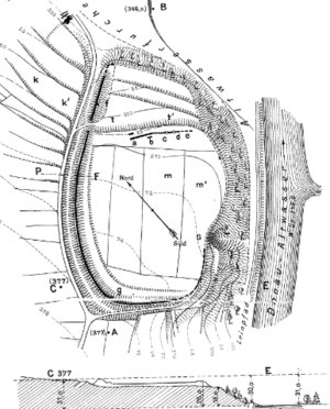
Section fortification Bürg (Irnsing)
| Section fortification Bürg | ||
|---|---|---|
|
Irnsing ramparts with internal berm (1904) |
||
| Alternative name (s): | Burg Irnsing | |
| Creation time : | early medieval | |
| Castle type : | Höhenburg, spur location | |
| Conservation status: | Castle stable, wall and moat remains | |
| Place: | Irnsing - Neustadt on the Danube | |
| Geographical location | 48 ° 50 '29.1 " N , 11 ° 45' 27" O | |
|
|
||
The Burg section fortification , also known as Burg Irnsing , is an abandoned spur castle approx. 1200 m east-northeast of the church of Irnsing , a district of the Lower Bavarian town of Neustadt an der Donau in the Kelheim district of Bavaria . The Bürg lies on the left bank of the Danube on a blunt spur nose. It is assigned a traffic-geographic significance, since from it the Danube valley to the south and north could be overlooked and controlled. The complex is listed in the Bavarian Monument Atlas under monument number D-2-7136-0172 as an open-air settlement of the Upper Palaeolithic ( Aurignacia ).
description
The almost rectangular rampart has an inner area of approx. 200 × 145 m. A hook-shaped wall cuts off the southwest and northwest sides from the hinterland. The wall has an average height of 1.5 m, it is preceded by a 2 m deep and 6 m wide trench. The usable area was just under 3 hectares. The 29 m long slope, which descends steeply to the Danube, offers adequate protection on the south-east side, while three terraces are located in front of the narrow northern side; the upper terrace was separated from the middle and interior by an embankment at the beginning of the 20th century. The old access was in the north, because there the ditch ends in a hollow and the wall ends 5 m in front of it, creating a natural driveway. The access from the south was created in 1895. At that time a 5 to 9 m wide and about 1 m high step in front of the wall on the inside was removed.
Excavations from 1895 have shown that the wall has a continuous, mortar wall 1.8 m thick and about 1 m high; it was heaped up from the outside with excavated trenches. On the north-eastern side, a 56 m long dry stone wall was found, which ran almost parallel to the edge of the terrace; three layers of this were still preserved. Since half-burnt pieces of clay with burnt-in wickerwork came to light, this could have been the substructure of a building.
history
The complex is dated to the early Middle Ages (built in the 7th century and expansion in the 9th / 10th centuries). On the inside, Upper Palaeolithic silices and numerous prehistoric ceramic fragments were found, which were assigned to the Altheimer Group , the Chamer Group and the Hallstatt Period. The mountain spur was already used in prehistoric times and the early medieval ramparts were added to an earlier system. Finds from Roman times were not made, which means that the assumption that the complex is a Limes fort , such as Abusina , which is located nearby , can be rejected. It is in the Bürg also suspected a medieval port on the Danube or the Bürg attributed a function in securing the Danube transition. During the time of the Hungarian storms , the facility was probably reinforced. It is assumed that the transfer of royal property by Emperor Heinrich II at Eining in 1002 to the Old Chapel in Regensburg and, above all, at Irnsing in 1014 to the diocese of Bamberg, led to the fortifications becoming less important. The Bürg is mentioned around 1387 in an income register of the Weltenburg abbot Diepold, at that time the "Horse XVI Pifang auf der purg" and "Hantz Assgern I (Acker) an der puerg" owned the monastery; there is no longer any talk of a castle.
literature
- Johann Auer: Fortifications and castles in the Kelheim district from the Neolithic to the late Middle Ages. Verlag der Weltenburger Akademie Aventinum eV, Abensberg 2008, pp. 220–221.
- K. Popp: Irnsing Castle. Contributions to the anthropology and prehistory of Bavaria , 1905, Vol. 15, pp. 1–13.
Web links
- Entry on Wallburg Birg, Bürg (Irnsing) in the private database "Alle Burgen".
- Stephan Gröschler: Bürg Irnsing , accessed on June 11, 2020.
Individual evidence
- ↑ Jörg WE Fassbinder, Roland Linck: Magnetometer prospection of the probably early medieval fortification near Irnsing. City of Neustadt ad Donau, Kelheim district, Lower Bavaria. October 2012, accessed June 11, 2020.
- ↑ Andreas Boos, Karl Schmotz: Fortifications of the early and older Middle Ages in the eastern Bavarian Danube region. In: L. Husty, R. Sandner, K. Schmotz (Eds.): Lectures 30. Niederbayerischer Archäologentag . 2012, ISBN 978-3-89646-241-1 , pp. 147–226 ( landkreis-deggendorf.de [PDF; accessed June 11, 2020]).


