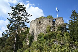
Rabenstein castle ruins (Lower Bavaria)
| Rabenstein castle ruins | ||
|---|---|---|
|
Rabenstein castle ruins - view of the east side of the residential tower with the high entrance |
||
| Alternative name (s): | Ritenburg | |
| Creation time : | Early 12th century | |
| Castle type : | Two-part hilltop castle in a spur location | |
| Conservation status: | ruin | |
| Standing position : | Count | |
| Place: | Riedenburg | |
| Geographical location | 48 ° 57 '37.9 " N , 11 ° 40' 55.1" E | |
| Height: | 430 m above sea level NN | |
|
|
||
The Rabenstein castle ruins , formerly also called Ritenburg , is a former high medieval aristocratic castle at the end of the Schambach valley on the steep mountain slope below Rosenburg Castle above the town of Riedenburg in the Lower Bavarian district of Kelheim in Germany .
The ruin of the Spornburg is freely accessible at all times and today serves as a lookout point .
Geographical location
The former Rabenstein Castle is located in the eastern part of the Franconian Alb in the lower part of the Altmühltal , above the confluence of the Schambach in the Altmühl or in the Main-Danube Canal in the Altmühltal Nature Park . It stands 125 meters east of the immediately neighboring Rosenburg Castle on an east-facing spur hill at about 430 m above sea level. NN height and thus 100 meters above the valley. The ruin is located about 100 meters south-southwest of the Catholic parish church of St. Johann Baptist in Riedenburg.
There are other former medieval castles in the vicinity: The Rabenstein castle forms the Riedenburg castle group with the Rosenburg, the former Tachenstein castle just a few hundred meters northwest and the Aicholding castle on the opposite side of the Altmühltal. The well-preserved Prunn Castle is within sight of the ruins, just a few kilometers down the Altmühl Valley, and the Randeck Castle ruins a little further down the Altmühl Valley . Up the valley in the Schambachtal is the Hexenagger Castle and some castle stables around the village of Hexenagger . To the northwest are the Eggersberg Castle and the ruins Eggerberg to that obtained in ruins keep , and a little further the ruin Wing Mountain .
history
The castle was probably built by the Burgraves of Regensburg at the beginning of the 12th century. From 1400 the manor was no longer mentioned and fell into disrepair after being destroyed in the 16th century. Remnants of the wall of the residential tower and fragments of the curtain wall are still preserved from the former castle complex, which had an upper castle and a lower castle . The Burgplatz is now a ground monument .
literature
- Georg Paula , Volker Liedke, Michael M. Rind : District of Kelheim (= Bavarian State Office for Monument Preservation [Hrsg.]: Monuments in Bavaria . Volume II.30 ). Schnell & Steiner publishing house, Munich / Zurich 1992, ISBN 3-7954-0009-0 .
- Ingrid Burger-Segl: Archaeological Hikes, Volume 1: Lower Altmühltal . 2nd edition, Verlag Walter E. Keller, Treuchtlingen 1993, ISBN 3-924828-42-3 , pp. 64-67.


