Eggersberg Castle
| Eggersberg Castle | |
|---|---|
|
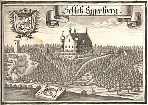
Eggersberg Castle with the ruins of Eggersberg Castle on the left edge of the picture. Engraving by Michael Wening, 1701 |
|
| Alternative name (s): | Alt-Eggersberg |
| Creation time : | 13th Century |
| Castle type : | Höhenburg, spur location |
| Conservation status: | Wall remains, neck ditch |
| Standing position : | Dukes |
| Construction: | Ashlar and quarry stone masonry |
| Place: | Riedenburg- Obereggersberg |
| Geographical location | 48 ° 58 '25.6 " N , 11 ° 38' 54.8" E |
| Height: | 440 m above sea level NN |
The castle Eggerberg later, Alt-Eggerberg mentioned, which is ruin a Spur castle behind the castle Eggersberg just north of the hamlet Obereggersberg the city Riedenburg in the district of Kelheim in Bavaria , Germany . The castle was once enthroned at 440 m above sea level. NN on a rock tower protruding into the Altmühltal, the so-called church rock, today only a few remains of the wall have survived.
history
The castle was built in the 13th century and was first mentioned in 1326 as "Feste Eggersberg", it was owned by the Bavarian dukes. These pledged the castle from the end of the 14th century to Wilhelm den Fraundorfer, around 1417 to Balthasar Muracher, 1435 to Haimeran von Muggenthaler , 1480 to Georg von Pappenheim and 1485 to Count Jörg (Georg I) von Helfenstein († 1517). In 1520, the count widow Elisabeth, née Schenkin von Limpurg , and her daughter, Wandelburga (Waldburg), who was around eleven at the time, returned the Eggersberg official pledge to the Bavarian dukes.
In 1491 the castle was destroyed by Duke Albrecht IV in the course of the Lion War and demolished in 1613 after repair work.
Most of the still looming remains of the wall come from a baroque chapel built on the castle grounds in 1736 , most of which collapsed in 1806.
The remains of the ashlar wall of a keep , the remains of a wide and deep, semicircular neck ditch and a chapel are still around four meters high from the former castle complex . The Burgplatz is part of the ensemble E-2-73-164-2: "The ensemble includes the small Burgweiler Obereggersberg on a ridge above the Altmühltal, with the former Eggersberg fortress on a ledge in the north and the new castle in the south". In the possession of Wittelsbach since the 13th century, the castle was pledged to various vassals until it fell into disrepair due to the Lion War in the 15th century, the last of which is called "Jörg von Helfenstein" in 1485. The parish church that was inside the Bering was also destroyed and replaced by a baroque chapel around 1700. The moat and the remains of the curtain wall have been preserved from the early 13th century castle , only the ruins of the chapel remain. At the beginning of the 17th century, the ducal caretaker's son Adam Jocher built the new castle with an economic courtyard and outbuildings about 350 meters south of the castle ruins. Between the old fortress and the new manor house, small houses and rural side farms were built in irregular rows with only a small corridor to the west and south-east. Most of the property, which has now been renovated, is part of the only north-south access road that widens like an anger in the middle area in front of the stately former rectory and ends at the outer bailey. The townscape is determined by the soaring stepped gable building of the new castle with its corner towers, the baroque hipped roof building of the former rectory with the former castle tavern behind it and the tree-surrounded castle ruins on the cliff ledge. The small farms are mostly one to two-story plastered gabled houses from the 18th and 19th centuries as typical Jura houses with limestone roofs. Only a few of these homesteads and small houses have survived today, they have mostly been replaced by new buildings. Monument D-2-73-164-100 of the Bavarian State Office for Monument Preservation is: “Ruin of the old Eggersberg Castle; Ruins of a baroque chapel, quarry stone and ashlar masonry, around 1700; Ruins of the former keep, ashlar masonry with bossing, early 13th century; Section ditch and remnants of the ring wall, quarry stone masonry, early 13th century ”, soil monument D-2-7035-0008:“ Underground findings in the area of the medieval castle ruins Obereggersberg and the baroque church ruins ”.
literature
- Michael Weithmann: Castles and palaces in Lower Bavaria - guide to castles and palaces in the Bavarian Forest, between the Danube, Isar and the lower Inn Valley . Verlag Attenkofer, Straubing 2013, ISBN 978-3-936511-77-2 , p. 97.
- Friedrich-Wilhelm Krahe: Castles of the German Middle Ages - floor plan lexicon . Special edition. Flechsig Verlag, Würzburg 2000, ISBN 3-88189-360-1 , p. 163.
- Ingrid Burger-Segl: Archaeological Hikes, Volume 1: Lower Altmühltal . 2nd Edition. Verlag Walter E. Keller, Treuchtlingen 1993, ISBN 3-924828-42-3 , pp. 72-73.
- August Sieghardt: Castles and palaces in the Danube and Altmühl valleys . Regensburg undated
Web links
- Reconstruction drawing by Wolfgang Braun
Individual evidence
- ↑ Location of the castle ruins in the Bavarian Monument Atlas
- ↑ a b Ingrid Burger-Segl: Archaeological Walks, Volume 1: lower Altmühltal , p. 73
- ↑ a b Michael Weithmann: Castles and Palaces in Lower Bavaria - Guide to castles and palaces in the Bavarian Forest, between the Danube, Isar and the lower Inn Valley , p. 97
- ↑ List of monuments for Riedenburg (PDF) at the Bavarian State Office for Monument Preservation (PDF; 169 kB)


