Acıgöl (Çardak)
| Acıgöl | ||
|---|---|---|

|
||
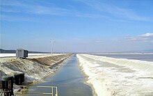
| View from the north bank of the Beşparmak; the salt-encrusted seabed can be seen in the background. | ||
| Geographical location | between Denizli Province and Afyonkarahisar , Turkey | |
| Tributaries | Kocaçay | |
| Drain | no drain | |
| Location close to the shore | Çardak , Başmakçı , Dazkırı | |
| Data | ||
| Coordinates | 37 ° 49 '18 " N , 29 ° 50' 27" E | |
|
|
||
| Altitude above sea level | 836 m | |
| surface | 50 to 156 km² | |
| length | 15 to 28 km | |
| width | 5 km to 10 km | |
| Maximum depth | 2.1 m | |
The Acıgöl ( Turkish for Bitter Lake ) is the second largest salt lake in Turkey .
Surname
The name of the lake indicates the salty character of the water. In ancient times it was called the Lake of Sanaos . The lake has had its current name officially since 1923. An outdated name for the lake in Turkey is Çardak Gölü (German: Çardak-See).
location
The lake is located in the Anatolian highlands between the provinces of Denizli and Afyonkarahisar , with about a quarter of the lake (the southwest part) being in Denizli and the greater part of the lake belonging to Afyon. The next big city Denizli is about 60 km away. Because of the fluctuating size of the lake, there are no settlements directly on the shore. The closest places to Acıgöl are Çardak (Denizli province) in the west, Yüreğil on the north, Başmakçı (both Afyon province) in the east and Gemiş (Denizli province) on the south bank. The national road 320 leads along the north bank from Denizli to Dinar .
Geologically, the lake is located in the Acıgöl Basin, which runs from northeast to southwest parallel to the Taurus chains . The basin itself is approximately 45 km long and 9 to 12 km wide. Its bottom is on average at 850 m above sea level; therefore the basin has no drainage. The Acıgöl is framed in the south by the up to 2,033 m high Sögüt Daği (German: "Weidenberge") and in the north by the mountain ranges of Maymun Dağ (German: Affenberg; 1,733 m) and Beşparmak Dağı (German: Five-Finger Mountains ; 1,612 m).
Based on sediments and coastal deposits, we know that the lake had a significantly higher water level during the Würm Ice Age , up to 35 m above today's level. At that time there was also an overflow towards Bozkurt to the Great Meander (Turkish: Büyük Menderes), which can still be recognized today as a dry valley. Geologically speaking, it is a very young lake.
water
Water surface
The surface of the lake is highly fluctuating and depends on the winter rainfall and the snowmelt in spring. Except for the Kocaçay stream, which flows into the lake on the east bank, there are no tributaries. The lake receives additional water from meltwater from the surrounding mountains and springs on the lake floor. In winter, the lake surface can rise to 156 km². In the dry summer months, the water withdraws, leaving the lake floor as a wide clay plain with a thin layer of salt on top. The water surface can shrink to up to 50 km².
Chemical Analysis
Acıgöl is a hypersaline lake. Analyzes show a salt content of 8 to 200 mg / l; Sodium hydrogen sulfate , NaHSO 4 112 to 15,232 mg / L; Chlorine 290-35320 mg / l; Magnesium hydrogen carbonate 82 to 3425 mg / l; and calcium 102 to 745 mg / l.
Flora and fauna
The entire basin is designated by the Turkish government as a " Class B wetland ", which unfortunately has little effect on the protection of nature.
The lake is surrounded by typical halophyte plants such as B. the reports (Atriplex). Aquatic plants and animals cannot exist in the salty environment of the lake, but there are unique microorganisms, halophyl bacteria, in Acıgöl.
The Acıgöl Basin is an important refuge for birds. According to the IBA criteria (Important Bird Areas), it is an important collection point for water and migratory birds. Particularly noteworthy are the Kentish plover Charadrius alexandrinus and the rusty goose Tadorna ferruginea . There are also significant populations of the salmon tern Gelochelidon nilotica , the great bustard Otis tarda , the avocet Recurvirostra avosetta and the black-winged lapwing Vanellus spinosus . A total of 176 bird species were counted.
Due to increasing industrialization and population, the lake is increasingly suffering from environmental pollution, so that some species of birds have not been spotted anymore.
Economic use
The minerals found in the lake have been mined by the Estuz company since 2002; salts (sodium chloride, sodium sulphate), potassium, magnesium, sodium, sulphates and gypsum are broken down. Every year up to 150,000 tons of salts are extracted in the evaporation ponds and packed in Dazkiri.
Individual evidence
- ^ Geographical Turkey ( Memento from May 22, 2014 in the Internet Archive )
- ↑ http://meetingorganizer.copernicus.org/EGU2014/EGU2014-6038.pdf
- ↑ Denizli'nin Tarihçesi ( Memento from May 31, 2011 in the Internet Archive ) Göller, 11 Ocak 2012 - TC Denizli Valiliği
- ↑ http://www.globalspecies.org/birdareas/display/763
- ↑ http://www.haberler.com/acigol-un-flamingolari-tarihe-karisti-2995492-haberi/
- ↑ http://www.estuz.com/acigol_tuzu.html

