Adamaoua (Cameroon)
| Adamaoua (French) Adamawa (English) Adamaua |
|
|---|---|
| Basic data | |
| Capital : | Ngaoundéré |
| Area : | 63,691 km² |
| Residents : | 1,201,000 (calculation, 2015) |
| Population density : | 18.85 inh / km² (calculation, 2015) |
| ISO 3166-2 : | CM-AD |
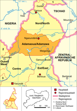
Adamaoua ( French ) or Adamawa ( English ) , ( German Adamaua ) is a region of Cameroon with the capital Ngaoundéré . The name is derived from Modibo Adama , the founder of the Emirates Adamaua .
geography
The region lies in the middle of the country and borders in the north with the region North / North , in the east with the Central African Republic , in the southeast with the region Est / East , in the south-west with the region Center and in the west with the regions East / West and Nord-Ouest / Northwest and Nigeria . The south of the region is the Mbam Djerem National Park .
The topography of the region is shaped by the Adamaua highlands . In the province, this forms the watershed between the Benue , the largest tributary of the Niger , the Logone, which flows into the Chad basin , and the Sanaga .
Population development
Since 1976 the number of inhabitants has more than tripled.
| year | population |
|---|---|
| 1976 census | 359.334 |
| 1987 census | 495.185 |
| 2005 census | 884.289 |
| 2015 estimate | 1,201,000 |
Political structure
The region is divided into five districts:
| district | District capital |
|---|---|
| Djérem | Tibati |
| Faro-et-Déo | Tignère |
| Mayo banyo | Banyo |
| Mbéré | Meiganga |
| Vina | Ngaoundéré |
history
The region (until 2008 province) was created in 1983 with the division of the province Nord / North into the provinces Adamaoua / Adamawa, Extrême-Nord / Extreme North and today's province Nord / North .

literature
- Theodora Büttner : The socio-economic structure of Adamauas in the 19th century, Leipzig 1965, DNB 481284508 ( habilitation thesis Uni Leipzig June 11, 1965).
Web links
Individual evidence
- ↑ Cameroon: Regions & Cities - Population Statistics in Maps and Tables. Retrieved May 8, 2018 .


